Duration
14 Days
![]() Unbeatable Holiday Offers - Save Up to 20% on Your Next Adventure!
Unbeatable Holiday Offers - Save Up to 20% on Your Next Adventure!
Everest Gokyo Chola Pass Trek
Trip Difficulty
ModerateMax. Altitude
5550 MetresGroup Size
2-16 PeopleBest Season
Mar-May & Sep-NovTransportation
FlightAccommodation
Hotel, Lodge, TeahouseMeals
Breakfast, Lunch & Dinner- Your safety, our no 1 priority
- Best price guarantee
- Experienced & dedicated team
- Easy booking, no hidden charge
- You can customize this trip

Trip Overview
The Everest Gokyo Chola Pass Trek is one of the most scenic and adventurous trekking routes in the Everest region of Nepal. It is an ideal adventure that allows a person to have something beyond the usual Everest Base Camp,with spectacular lakes at high altitude, dramatic glaciers, a tough mountain pass, and the legendary base of the highest mountain in the world.
The road leads you through old Sherpa villages, brightly painted monasteries and beautiful valleys, which gives a great cultural and natural experience.
The Everest Gokyo Chola Pass Trekbegins with a flight to Lukla (2,840 m / 9,318 ft) and proceeds along the Dudh Kosi River, passing through numerous villages, includingPhakding and Namche Bazaar (3,440 m / 11,286 ft), the bustling hub of the Khumbu Valley.
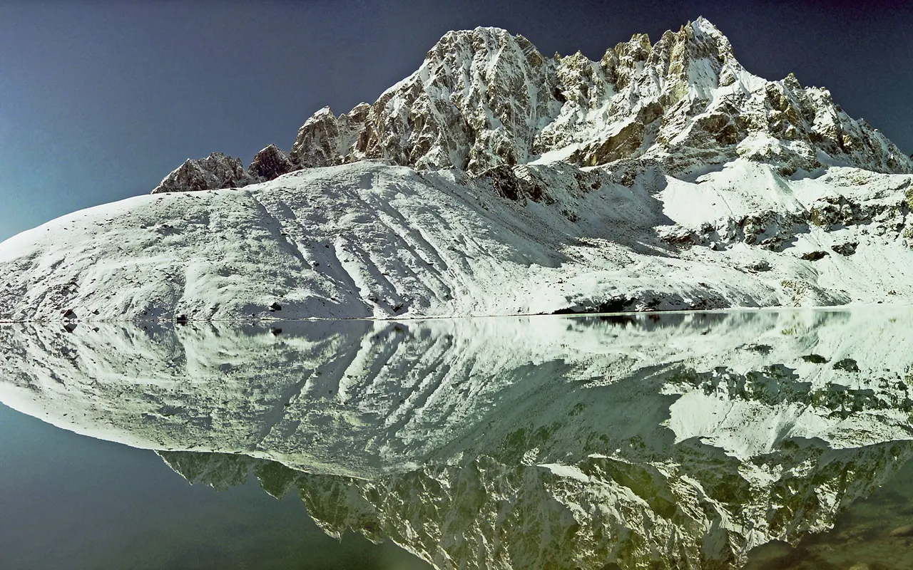
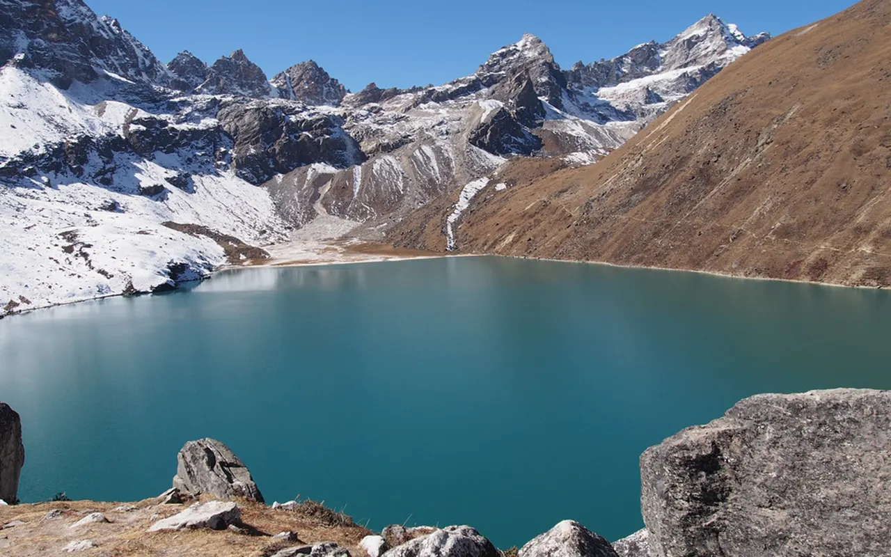
The next point in the trek isthe entrance to a peaceful Gokyo Valley, which is home to beautiful turquoise Gokyo Lakes at approximately 4,790 m / 15,715 ft. One of the highlights of the trek is the ascension of Gokyo Ri (5,357 m / 17,575 ft), which provides one of the best panoramic views of Mount Everest, Cho Oyu, Lhotse, Makalu and the huge Ngozumpa Glacier.
The journey proceeds with crossing Cho La Pass (5,420 m / 17,782 ft), which is a tough terrain. This is a challenging and steep mountain pass that usually has snow and ice, which is a challenging climb that pays off with spectacular scenery of the Alps.
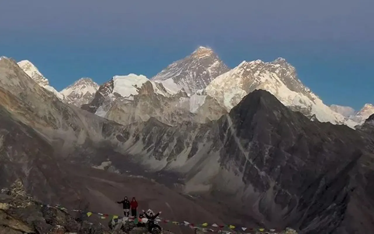
The route merges with the traditional Everest trail after the pass and to the Everest Base Camp (5,364 m / 17,598 ft). The second significant sightseeing is a hike to Kala Patthar (5,550 m / 18,209 ft), the highest point of the trek,for the optimal place to see the best sunrise andclose-up views of Mount Everest.
Therefore, Everest Gokyo Chola Pass Trek is a tough yet extremely rewarding experience that needs good fitness, appropriate acclimatization and a positive attitude. Himalayan Pathways offers a well-planned, safe and enjoyable trekking experience with the help of trained supporting staff.
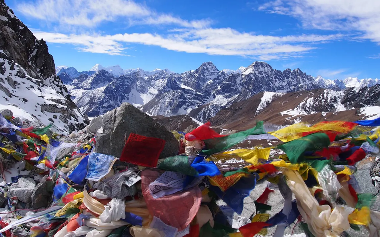
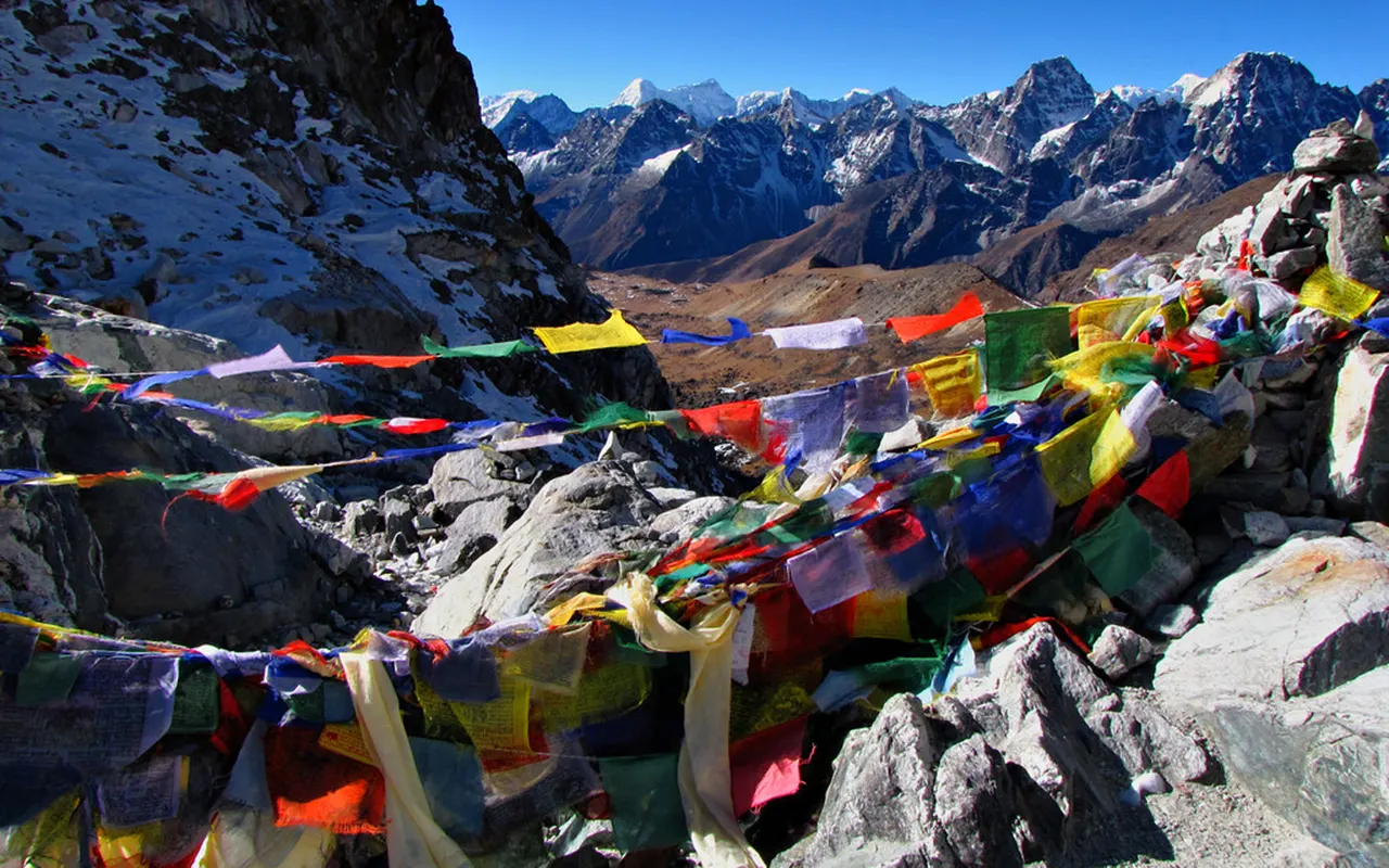
Highlights of Everest Gokyo Chola Pass Trek
- Scenic flight to Lukla (2,840 m / 9,318 ft), providing an adventure start with spectacular views of the Himalayas.
- Explore Namche Bazaar (3,440 m / 11, 286 ft), the cultural capital of Sherpas, which is full of cafes and mountain views.
- Walk around the gorgeous turquoise Gokyo Lakes (4,790 m / 15,715 ft), the most beautiful high-altitude lakes in the Himalayas.
- Hike toGokyo Ri (5,357 m / 17,575 ft) to have an amazing panoramic view of Everest, Cho Oyu and the huge Ngozumpa Glacier.
- Traverse the adventurous Cho La (5,420 m / 17,782 ft), a high-altitude arduous pass with spectacular mountain scenery.
- Hike to the Everest Base Camp (5,364 m / 17,598 ft) and be at the foot of the highest mountain in the world.
- Experience a memorable sunrise at Kala Patthar (5,550 m / 18,209 ft), the best point forseeingclose-up views of Mount Everest.
Everest Gokyo Chola Pass Trek Itinerary
Our adventure will start early in the morning in Kathmandu, where we will drive off in Manthali, leaving around 1:00 AM. On arriving at the airport, we board a brief yet thrilling flight to Lukla (2,840 m / 9,318 ft). It is an experience to see the Himalayan mountains from the air, and the landing at the hillside Lukla airport is an experience.
We meet our trekking staff and pack our supplies, after which we begin our first trek on the journey. It is a mild downwards path along the Dudh Koshi River, through little Sherpa villages, prayer wheels and suspension bridges. This is an easy walk, and it is ideal to stretch our legs. On the road, we go through pine forests and mountainous landscapes.
Having had a pleasant walk, we arrive in the village of Phakding (2,610 m / 8,563 ft). We check into a comfortable teahouse and spend the first night in the Everest region.
Activity & Duration
4 hrs hiking or drivingHighest Altitude
2,840m / 9,318ft (Phakding)Meals
Breakfast, Lunch & DinnerAccommodation
TeahouseAfter breakfast, we keep on trekking along the Dudh Koshi river towards the north. The route goes through the pine and rhododendron forests and over a number of suspension bridges adorned with prayer flags. We pass by small villages and arrive in Monjo, where we get into Sagarmatha National Park.
At this point, the scenery is more dramatic. The crossing of the renowned Hillary Suspension Bridge at the height of the river is one of the highlights of the day. The trail becomes steep after lunch, and we are on the long climb towards Namche Bazaar. We are slow in our steps and frequent in our rests.
On our journey, we also have our first glimpse of Mount Everest (8,848 m / 29,031 ft), which is highly thrilling. In the afternoon, we arrive at Namche Bazaar (3,440 m / 11,286 ft), an interesting mountain town where shops, bakeries and views of the mountains are available. We relax and rest at our lodge.
Activity & Duration
6 hrsHighest Altitude
3,440m / 11,286ft (Namche Bazaar)Meals
Breakfast, Lunch & DinnerAccommodation
LodgeWe have a day of acclimatisation today to make our bodies adapt to the altitude. We take a brief hike up to the Everest View Hotel (3880 m/ 12730 ft) after breakfast. It is a slow but constant walk, and the scenery is improved by our ascent. Our hotel is situated in a great location where we have a fantastic panoramic view of the mount Everest, Lhotse, Ama Dablam, and other mountains.
We take photos of the mountains as we relax with a warm drink. We can visit the nearby Sherpa villages such as Khumjung (3,780 m / 12,402 ft) later on, where visit the Hillary School and a small monastery.
Afternoon time is free to have some rest or visit the local shops or the Sherpa museum. This is a very significant day of rest because the day is active, and we remain healthy as we proceed further up the trek.
Activity & Duration
5 hrsHighest Altitude
3,880m / 12,730ft (Everest View Hotel)Meals
Breakfast, Lunch & DinnerAccommodation
LodgeWe leave Namche after breakfast and head to a ridge above the town. We pass Kyangjuma and Sanasa, and we follow the path and head off to the more peaceful Gokyo Valley. This section of the hike is quieter and not so congested. We pass through juniper-bushed hillsides and come to Mong La Pass (3,975 m 13,041 ft), which is decorated with prayer flags.
We then return to Phortse Tenga by the river after enjoying the views, which come in a very steep descent. Lunch is followed by a long walk up through rhododendron and pine forests. Birds and wildlife may be observed on the way.
In the afternoon, we reach the little village of Dole (4,110 m / 13,484 ft). We are now quite comfortable, with the altitude being greatly increased.
Activity & Duration
6 hrsHighest Altitude
4,110m / 13,484ft (Dole)Meals
Breakfast, Lunch & DinnerAccommodation
TeahouseThe walk on this day proceeds uninterrupted up the gorgeous Gokyo Valley. We take leave from Dole after breakfast and pass the yak pastures and little villages. The path slowly ascends beyond the tree line and presents us with expansive mountain scenery.
As we continue to ascend, we start noticing Cho Oyu (8,188 m / 26,864 ft) in the distance. It is a silent and calm walk that has a smaller number of trekkers. We cross such villages as Luza and arrive at Machhermo (4,470 m / 14,665 ft) in a few hours before noon.
Machhermo is a small village that is surrounded bymountains and open valley scenery. During the afternoon, we sleep and rest to save our energy. It is an evening of stillness and a clear night sky with stars.
Activity & Duration
5 hrsHighest Altitude
4,470m / 14,665ft (Machhermo)Meals
Breakfast, Lunch & DinnerAccommodation
TeahouseWe trek further after breakfast to the popular Gokyo Lakes. The path leads upwardsto the first glacial lake. On our walk, the scenery turns out to be more open and rockier. We cross the second lake and eventually arrive at the major Gokyo Lake, which is also known as Dudh Pokhari. The blue water is beautiful in contrast with the snowy mountains.
Gokyo village is located on the side of the lake at 4,790 m (15,715 ft). The Cho Oyu stands over the valley, providing a spectacular view. Upon arrival, we are served lunch and take some free time.
You can go on a small stroll around the lakes or just have a leisurely timeby the lake. This location is special due to the calm setting and reflection of the mountains. We spend a peaceful night in a teahouse at Gokyo in the evening.
Activity & Duration
5 hrsHighest Altitude
4,790m / 15,715ft (Gokyo village)Meals
TeahouseAccommodation
TeahouseWe start extremely early in the morning and climb Gokyo Ri. The trail is steep and difficult because it is high in altitude. After several hours of unrelenting uphill climbing, we are at the top of Gokyo Ri (5,357 m / 17,575 ft).
We are in the best of views in the Himalayas and Mount Everest, Lhotse, Makalu, Cho Oyu and the long Ngozumpa Glacier can be viewed down below. We then head back to Gokyo village, taking photos and having a rest and then bring ourselves slowly back to the village to have breakfast.
We later put on our bags and crossed the rocky Ngozumpa Glacier. The walk is slow but scenic. Afternoon, we arrive at Thangnak (4,700 m / 15,420 ft) and have lunch and get ready to face the next day’s adventure.
Activity & Duration
8 hrsHighest Altitude
5,357m / 17,575ft (Gokyo Ri)Meals
Breakfast, Lunch & DinnerAccommodation
TeahouseIt is a difficult yet rewarding day in the Everest Gokyo Chola Pass Trek. Thangnak (4,700 m / 15,420 ft) is where we wake up early and head to Cho La Pass (5,420 m / 17,782 ft). The path is very steep and rocky at the beginning, and the elevation is very high, which makes the walk difficult.
As we ascend in height, we find the road covered with snow and ice, and we proceed slowly and cautiously. Our steady climb reaches the Cho La Pass (5,420 m / 17,782 ft), which is marked by prayer flags. The pass brings about amazing scenery of the Ama Dablam, Cholatse and other mountains.
Then, we proceed to step down the other side, which is not only steep but also slippery. We reach the remote village of Dzongla (4,830 m / 15,846 ft) after an exhausting and long day, where we sleep and get our strength.
Activity & Duration
8 hrsHighest Altitude
5,420m / 17,782ft (Cho La Pass)Meals
Breakfast, Lunch & DinnerAccommodation
TeahouseToday is a shorter and easier walk compared to the hard Cho La Pass cross, which was made yesterday. We leaveDzongla (4,830 m / 15,846 ft) and take an easy path through expansive slopes with the mountainous scenery.
After an hour, we enter the major trail of Everest around Thukla. Here, we ascend a short but steep section to Thukla Pass, where there are stone memorials of those climbers and Sherpas who died on Everest. The mountain background and the prayer flags provide a serene and sensitive mood.
This is followed by a slowing down of the trail as we proceed on the rocky moraine of Khumbu Glacier. Its scenery is severe and alpine, and its mountains are high.
In the afternoon, we arrive at Lobuche (4,910 m / 16,109 ft), a little settlement below Lobuche East. It is an afternoon of rest and recovery as we prepare to reach the Base Camp of Everest.
Activity & Duration
4 hrsHighest Altitude
4,910m / 16,109ft (Lobuche)Meals
Breakfast, Lunch & DinnerAccommodation
TeahouseIt is a very special day because we are going to theEverest Base Camp today. We walk fromLobuche (4,910 m / 16,109 ft) to Gorak Shep (5,140 m / 16,864 ft) to the rocky trail that is located at the edge of Khumbu Glacier.
On arriving at Gorak Shep, we rest and eat lunch. Then we proceed to Everest Base Camp (5,364 m / 17,598 ft). This trail is on rocky glacier land with little rises and falls, and the air is thin and very slow.
We have finally reached the Everest Base Camp (5,364 m / 17,598 ft), which is beneath the Khumbu Icefall. It is a memorable experience that is full of pride and excitement. Once we have photographed them and celebrate the success, we go back to Gorak Shep and spend the night.
Activity & Duration
8 hrsHighest Altitude
5,364m / 17,598ft (Everest Base Camp)Meals
Breakfast, Lunch & DinnerAccommodation
TeahouseFor the hike to Kala Patthar (5550 m / 18209 ft), we begin very early in the morning. It is not an easy road, and the air is very cold, but the reward is phenomenal. The summit of Kala Patthar (5,550 m / 18,209 ft) is the most apt place to view a sunrise of Mount Everest, and Nuptse, Pumori, and several other mountains.
Once the photos are taken and the moment enjoyed, we then safely retrace our steps all the way back to Gorak Shep (5,140 m / 16,864 ft), where we are now ready to have breakfast.
We then start our long trek down the valley with Lobuche, onwards to Pheriche (4,240 m / 13,911 ft). The reduced height is cool, and the breathing is easier. We arrive at Pheriche in the afternoon, and spend the evening in a very pleasant way, after a memorable day.
Activity & Duration
8 hrsHighest Altitude
5,550m / 18,209ft (Kala Patthar)Meals
Breakfast, Lunch & DinnerAccommodation
TeahouseWe pass through beautiful villages and woods today. We leave Pheriche (4, 240 m / 13,911 ft), walk across Pangboche (3,985 m / 13, 074 ft) and make our way to Tengboche (3,860 m / 12,664 ft). We visit the popular monastery at Tengboche and have a glimpse of Everest and Ama Dablam.
Lunch is followed by a steep descent to the river at Phunki Tenga, followed by an uphill ascent using forested trails to Kyangjuma.
We will be back in Namche, which feels lively after days in the mountains. We are taking hot showers, nice meals and have time to congratulate ourselves that we finished the entire Everest Gokyo Chola Pass Trek with our crew.
Activity & Duration
7 hrsHighest Altitude
4,240m / 13,911ft (Pheriche)Meals
Breakfast, Lunch & DinnerAccommodation
TeahouseWe start our last day of the trek by having breakfast in Namche Bazaar (3,440 m / 11,286 ft). We steeply head down to the Dudh Koshi River, going through such villages as Monjo and Phakding. We pass across well-known suspension bridges and have a stroll through the woods, which are laden with prayer flags and mani stones.
We have lunch in Phakding (2,610 m / 8,563 ft) and proceed to Lukla. The final part comprises a slight uphill, which reminds us that we are not just done with the journey.
In the afternoon, we finally reach Lukla (2,840 m / 9,318 ft), where our journey started. We celebrate with our porters and guides in the evening and recount the memories and the stories of the journey.
Activity & Duration
8 hrsHighest Altitude
3,440m / 11,286ft (Namche Bazaar)Meals
Breakfast, Lunch & DinnerAccommodation
TeahouseWe fly back from the small airport in Lukla (2,840 m / 9,318 ft) after having breakfast. The brief flight is an additional glimpse of the Himalayan mountains on our way out of the Everest region. We fly back to Kathmandu (1,400 m / 4,593 ft) and see hills, rivers and valleys below.
Once there, we get into our hotel and have a hot shower and a well-deserved rest. The remaining day will be free time to relax or do shopping or to explore the city.
We also have a farewell dinner in the evening, where we celebrate the successful ending of the Everest Gokyo Chola Pass Trek. It is the moment to look back and see the adventure, friends and the memories on this remarkable journey.
Activity & Duration
1 hrsHighest Altitude
2,840m / 9,318ft (Lukla)Meals
Breakfast, Lunch & DinnerAccommodation
HotelPrice Includes and Excludes
What is included?
- Every airport transportation (both international and domestic flights, pickup and drop-off transfers).
- Sharing of a privately operated vehicle between Kathmandu andManthali (Ramechhap) when needed.
- Domestic flights round-tripKathmandu/ Manthali to Lukla.
- A qualified, fluent English-speaking trekking guide (with theirsalary, meals, accommodation, transport and insurance)
- Sagarmatha National Park entry permit and Pasang Lhamu Rural Municipality charges.
- Three meals a day (breakfast, lunch, dinner) with tea or coffee.
- 13-night stay at mountain teahouses on twin-sharing basis.
- Safe drinking water offered (purification tablets and a refillable bottle of water)
- Himalayan Pathways duffel bag to be used on the trek (to be returned after).
- Warm sleeping bag (-20 °C) in case necessary (to be returned later on) to be used during the trek.
- Gokyo Chola Trek route map and trip guide in print.
- Free trekking cap from Himalayan Pathways.
- Walking poles (trekking sticks) when needed.
- Basic medicines, a first aid medical kit, and an oximeter are carried by the guide.
- All the required government and local taxes, trekking charges and service fees.
What is not included?
- Nepal Entry visa and charges
- Travel insurance (inclusive, including high-altitude trekking and emergency evacuation)
- Breakfast and dinner in Kathmandu before and after the trek
- Any personal beverages and snacks during the trek (bottled water, soda, alcohol, speciality coffees, etc.).
- Personal costs, which include phone calls, internet/Wi-Fi, charging devices, laundry, and hot showers in teahouses.
- The additional accommodation and food on the trek because of delays because of flight cancellations or bad weather.
- Porter to carry personal luggage
- Tips for your guide and porter
- Any additional expenses are not indicated in the Cost Includes section.
Trip Information
How Difficult is the Everest Gokyo Chola Pass Trek?
Everest Gokyo Chola Pass Trek is regarded as a difficult high-altitude trek and is more suitable for trekkers who are well-fitted and have minimal experience in trekking. You take approximately 5-8 hours daily walking on rocky and rough mountain paths with lots of up and down on the mountain.
The challenge primarily consists of the elevation since the trail leads to Kala Patthar, 5,550 m / 18,209 ft and passes through Cho La Pass, 5,420 m / 17,782 ft. The air at these heights is thin and thus, walking in it may feel tiring, even making one move slowly.
The Cho LaPass is steep and is also snowy or icy, and might need the application of micro-crampons. There are no technical climbing skills required, though. Through adequate acclimatisation, a gradual trek, and psychological will, trekkers can finish the Everest Gokyo Chola Pass Trek and consider it as a challenge, yet a very fulfilling one.
Weather and Best Season
Everest Gokyo Chola Pass Trek is done in spring (March to May) and autumn (September to November). These seasons bring about stable weather and clear skies, as well as great views of the mountains.
During spring, the weather is pleasant, the flowers start to bloom along the trails, and the time of day is extensive. Autumn is associated with cool weather, good visibility and easy trekking. At Namche Bazaar (3,440 m / 11,286 ft), the day temperatures do not exceed 10 °C to 20 °C during the day, whereas nights at elevations above 4,790 m (Gokyo) are considerably lower.
The rainy season (June to August) is characterised by heavy rain and clouds, and delays at the airport, leading to a hard time trekking. The winters (December to February) are sunny but very cold and snow-white, particularly in Cho La Pass (5,420 m / 17,782 ft). The spring and the autumn are favourable to the majority of trekkers.
Food & Drink during the Trek
The meals are provided in tea houses along the way during the Everest Gokyo Chola Pass Trek. The food is not complicated;it is very filling and keeps your body full of energy to help you survive long trekking days.
A typical and widely eaten dish is dal bhat that consists of rice, lentil soup, vegetables and pickles, and is served in unlimited refills. The other choices are noodle soup, pasta, fried rice, momos (dumplings), porridge, eggs, and pancakes.
The higher you are, the smaller the menu available, but the food is still sustaining. A lot of trekkers prefer vegetarian food because meat is transported from low altitudes, and this does not necessarily mean that it is fresh.
Hot drinks such as ginger tea, lemon tea, and milk tea are very common as far as drinks are concerned. To remain hydrated and healthy at high altitude, drink boiled water or purified water only.
Altitude Sickness and Suggestions
The Everest Gokyo Chola Pass Trek has a significant issue of altitude sickness since the path remains above 3,000 m / 9,843 ft throughout most of the days. Acute Mountain Sickness (AMS) is characterised by a headache, nausea, lack of appetite, dizziness, and insomnia. The symptoms may be found in such locations as Namche Bazaar (3,440 m / 11,286 ft) or Gokyo (4,790 m / 15,715 ft).
The most effective prevention is gradual ascending and correct acclimatisation. Take a lot of water, eat better, and no alcohol or smoking. Slowly going up and down the mountain, by taking the rule of trek high, sleep low, can get your body accustomed to it.
Some trekkers use Diamox only after visiting a doctor. In the event of an increase in symptoms, the most effective way out is to go down the mountain or undergo a helicopter evacuation. Everest Gokyo Chola Pass Trek guides are medically trained to identify AMS, and they will make your safety a priority in all situations.
Preparation and Fitness
The Everest Gokyo Chola Pass Trek is much easier with good preparation. This is a trek that is hard to undertake. You will need to begin training at least 8-12 weeks before the trip. Pay attention to developing cardiovascular health by hiking, jogging, riding a bicycle, or climbing stairs. Do long walks with a backpack to trainfor the daily trekking of 6-7 hours. Legs and core strength training are used to assist with steep descents and ascents.
The psychological training is also a major factor because cold weather, basic facilities, and weather delays may be quite demanding.
Ensure that your trekking shoes are of good quality and have been sufficiently broken in, and that you test your equipment before the trip. By being in shape, ready, and in the right mind, you can enjoy the success of the Everest Gokyo Chola Pass Trek.
Visa and Permits for the Everest Gokyo Chola Pass Trek
The foreigners looking to join the Everest Gokyo Chola Pass Trek will be required to have a Nepal tourist visa and two trekking permits. A Nepal visa is available upon landing at Kathmandu Airport, and as long as your passport is valid for at least 6 months.
In the case of trekking permits, the first is the Sagarmatha National Park Entry Permit, which is needed to enter the Everest region, which is near Monjo. The second one is the Khumbu Pasang Lhamu Rural Municipality Permit, which is typically acquired in Lukla (2,840 m / 9,318 ft). This region does not need a TIMS card. These authorisations are inspected at various stages of the trail.
Himalayan Pathwaysmakes all the permits for you so that you don’t have to engage in the hassle of documentation. You should always bring your permits on the trek to prevent wastage of time.
Health & Safety
In the Everest Gokyo Chola Pass Trek, health and safety are very crucial. Good hygiene is a way of avoiding stomach issues. You should wash your hands frequently and consume boiled or treated water only. Consume freshly cooked food and do not consume raw vegetables.
Taking the trek with a guide is much safer, particularly in the high and remote regions such as Cho La Pass (5,420 m / 17,782 ft). Wear heavy boots and carry trekking poles to keep the balance on a rocky or icy path. The altitude will change the weather very fast; therefore, warm clothes and a rain jacket should be included in the daypack.
The sun is very strong at such locations as Kala Patthar (5,550 m / 18,209 ft), so sunscreen and sunglasses become very necessary. The guides have oxygen monitors and first aid kits, and in case of necessity, a helicopter rescue. A well-managed and safe adventure by Himalaya Pathways, the Everest Gokyo Chola Pass Trek is a safe journey with sensible precautions.
Transportation
The means of transportation in the Everest Gokyo Chola Pass Trek include driving and flying. The trip is typically started by a domestic flight from Kathmandu or Manthali to Lukla (2,840 m / 9,318 ft). It is a scenic and exciting 30–35-minute flight, which is subject to weather. In high seasons, passengers can travel by road for 4-5 hours to Manthali Airport, and then fly to Lukla.
The only means of transport in the Everest area is on foot, since there is no road in Lukla. Porters and pack animals transport supplies.
The trek ends with flying down from Lukla to Kathmandu (1,400 m / 4,593 ft). The weather could trigger flight delays, so it would be prudent to have an additional buffer day. Most of the transport is handled by Himalayan Pathways in order to have a hassle-free trekking experience.
Travel Insurance
The Everest Gokyo Chola Pass Trek mandatorily require travel insurance since you will be hiking in remote regions with high elevations. It goes as far as Kala Patthar at 5550m 18209 ft, where there is a shortage of medical assistance in the mountains.
The comprehensive insurance must include high-altitude trekking at least up to 5,550 m / 18,209 ft and emergency helicopter evacuation to Kathmandu. Rescues by helicopters are extremely costly, and therefore, insurance covers you in the event of high expenses in case of an emergency.
Other things your insurance must cover are emergency medical treatment, trip cancellation or interruption, lost baggage and flight delays, particularly because flights to Lukla (2,840 m / 9,318 ft) can be postponed due to weather.
Carry a hard copy of your insurance policy and contacts of your emergency contacts, and leave another copy at home. Himalayan Pathways would assist in putting things into place on the ground, but it is up to you to ensure proper insurance when trekking the Everest Gokyo Chola Pass Trek.
Alternative Routes
The Everest area offers a wide variety of routes, based on the amount of time and comfort level. Everest Gokyo Chola Pass Trek is famous since it is a combination of Gokyo Lakes, Everest Base Camp, and high pass crossing.
In case you seek an even greater adventure, the Everest Three Passes Trek includes Cho La Pass, Renjo La (5,360 m / 17,585 ft) and Kongma La (5,535 m / 18,160 ft). This is more tedious and time-consuming.
In case you prefer not to cross Cho La Pass (5420 m/17782 ft), you can opt to visit Gokyo only (4790 m/ 15715 ft) and climb Gokyo Ri only (5357 m/17575 ft) and go back by the same way.
The other traditional one is the Everest Base Camp trek through Tengboche (3,860 m / 12,664 ft).
Himalayan Pathways provides you with an opportunity to tailor your Everest Gokyo Chola Pass Trek itinerary according to schedule and fitness.
Your Extra Expenses
Although your trekking package would include major expenses, still be prepared to spend some additional money on personal expenses during the Everest Gokyo Chola Pass Trek on personal expenses.
In Kathmandu, you have to pay for themeals and drinks that are not included in the package. Foods such as chocolate, energy bars, soft drinks, and coffee are also sold on the trail, but are more costly the higher up you go. Hot showers, Wi-Fi and charging devices are also paid for in teahouses. It can be a few dollars each time to charge a phone or camera battery, and Wi-Fi cards are likely charged.
Bottled water is chargeable; most trekkers prefer boiled water and purification tablets in reuseable water bottle.
It is normal to tip your guide and porter after the trek. Always keep cash in Nepali rupees because there are no reliable ATMs after Kathmandu.
Language & Communication
The Everest Gokyo Chola Pass Trek normally has no difficulty in communication since most of the guides and teahouse operators understand English. English menus and signs are frequent in such popular locations as Lukla (2,840 m / 9,318 ft) and Namche Bazaar (3,440 m / 11,286 ft).
The guide of Himalayan Pathways will use the English language and help you translate the interaction.
Nevertheless, it is a pleasant idea to learn some Nepali words to get in touch with people. In Nepali, you can say Namaste for hello, and you can thank using dhanyabad. Tashi Delek may also be used in Sherpa regions. Even a couple of simple expressions may make people smile.
Trekkers of various countries and nations will be met on the trail, and English is likely to be a common language. Being friendly and patient can be of great help. Altogether, language is not a significant obstacle, and the Everest Gokyo Chola Pass Trek does not seem to be hostile to foreigners.
Mobile Network, Internet & Charging Facilities
You can stay connected in the Everest Gokyo Chola Pass Trek, but it may be limited. In Lukla (2,840 m / 9,318 ft) and Namche Bazaar (3,440 m / 11,286 ft), mobile networks such as NTC and Ncell have good signal, but they weaken in elevation, such as Gokyo (4,790 m / 15,715 ft) and Gorak Shep (5,140 m / 16,864 ft).
The WIFI is provided by the teahouse or lodges, usually with a minimal fee. It is typically sufficient with messages and photos, but it can be slow and costly in high altitudes. You can charge phones and cameras in lodges and teahouses at a cost using solar power.
Carry a power bank and additional batteries, and leave your phone in aeroplane mode when there is no signal. A universal adaptor comes in handy. Staying in touch during the Everest Gokyo Chola Pass Trek is not hard if you plan a bit.
Don’ts on This Trip
To have a safe and respectful Everest Gokyo Chola Pass Trek, it has several significant “don’ts.’ Don’t hurry or neglect the acclimatisation process, particularly when going above Namche Bazaar (3,440 m / 11,286 ft) and to such destinations as Gokyo (4,790 m / 15,715 ft).
Do not disregard the presence of a headache, nausea, or dizziness and inform the guide about your situation. One should not drink or smoke at high altitude, as it may aggravate the dehydration and acclimatisation issues.
Do not litter, but keep your wrappers and bottles with you till you can dispose of them properly. Respect local culture, do not take photos of people without permission, and obey monastery regulations in areas such as Tengboche (3,860 m / 12,664 ft).
Do not walk alone,leaving your group, particularly near glacier locations and during the crossing of the Cho La Pass (5,420 m/ 17,782 ft), which can change weather quickly. These are just some of the don’ts that can make your Everest Gokyo Chola Pass Trek safer and more enjoyable.
Trip Extension
Most of the travellers decide to spend their Nepal trip either relaxing or on another adventure after doing the Everest Gokyo Chola Pass Trek. On the tourist list is the Chitwan National Park, where one can view rhinos, crocodiles, deer and probably tigers.
The other option is Pokhara, a quiet mountain lake city with boating, mountain views and optional activities such as paragliding.
In case you are culture-oriented, then Kathmandu Valley sightseeing is the place to be, with its UNESCO heritage sites and old towns.
Other trekkers will also incorporate a short trek in a different area to have some variety. Following days of the elevated altitude, up to Kala Patthar (5,550 m / 18,209 ft), a lower and warmer place may be invigorating.
Himalayan Pathways will be able to assist you in planning a trip extension to any schedule that suits you, whether you need the wildlife, culture or some rest. Your Everest Gokyo Chola Pass Trek trip can be even more fulfilling and memorable by adding a couple of days.
Photography & Drone Rules on Everest Gokyo Chola Pass Trek
The Everest Gokyo Chola Pass Trek is one of the best places for photography with stunning vistas at places such as Gokyo Ri (5,357 m / 17,575 ft) and Kala Patthar (5,550 m / 18,209 ft).
Taking photos on trails and in villages is welcome, but it is considered courteous to seek permission before taking photos of local people. In monasteries, the photography is different, as the courtyard is usually okay, but it can be limited or even prohibited in prayer halls. Never take chances or talk to your guide if you are unsure.
Use of drones is highly regulated in the Everest area due to the fact that it is a reserve. Flying drones normally takes special permission from the authorities and the national park, which may be costly and time-consuming. Drones can be fined and seized without the use of permits. To the majority of the trekkers, leaving the drones at home and enjoying the numerous spectacular perspectives along the Everest Gokyo Chola Pass Trek is better.
Tips for First-Time Visitors
If the Everest Gokyo Chola Pass Trek is your first visit to Nepal, planning will go a long way. Reach Nepal 1-2 days before the start of the trek to acclimatise and test your equipment. Use well broken in boots, awarmdown jacket, gloves, sunglasses/shades, and a nice sleeping bag.
Pre-train with cardio and walk5-8 hours per day to train your legs. Take your time and ease into it, particularly when ascending beyond Namche Bazaar (3,440 m / 11,286 ft) and above to greater elevation destinations such as Gokyo (4,790 m / 15,715 ft).
Take lots of water and eat well. Be prepared forsimple teahouses and nights. Be flexible, as Lukla (2,840 m / 9,318 ft) flights are liable to delays. All the trekkers are guided well by Himalayan Pathways and therefore feel safer and more at ease. Above all, have fun along the way.
Frequently Asked Questions
What is the duration of the Everest Gokyo Chola Pass Trek?
The total length of the trip is 14 days, of which 12 days are spent on the Gokyo Chola Pass Trek.
What is the maximum height of this trek?
Its highest place is Kala Patthar, which is approximately 5,550 meters (18, 209 feet) above sea level.
What is the total distance of the trek?
There are approximately 120 kilometres (75 miles) of walking distance throughout the whole Gokyo Chola Pass Trek path.
Is there any prior trekking experience required for the trek?
Good fitness and certain hiking experience help to overcome the difficult route through the Gokyo Chola Pass Trek, though not necessarily.
What are the accommodation arrangements on the trek?
You will be in teahouses – basic mountain cabins that have simple twin-sharing rooms and shared places.
Do they have toilets and showers on the trek?
Yes, but they are basic. Restrooms tend to be squat, and hot showers come with a small fee.
Does it have easy access to water?
Absolutely. You may have refills in teahouses or streams. Always use treated, bottled or boiled water.
Should I come with water purification pills?
It’s a good idea. Alternatively, filter or purchase boiled water to prevent any stomach problems.
How much weight do the Lukla flight allow in the luggage?
Typically, 15 kg per person (optionally 33 lb) in hand luggage. Extra charges are caused by excess baggage.
Is it possible to leave additional luggage in Kathmandu as I go on the trek?
Yes, the vast majority of hotels and the Himalayan Pathways office provide safe baggage storage in case of things you will not require on the trek.
Am I going to be able to recharge my phone and camera on the trek?
Yes, in most tea houses, you can charge your devices at a fee. Carry additional batteries and a power bank as well.
Does it have internet or Wi-Fi on the trek?
Most lodges have Wi-Fi that is charged, particularly in such villages as Namche. It gets slower and more unreliable at higher elevations.
Does this trek have network coverage?
There is partial coverage in the Everest Gokyo Chola Pass Trek with Ncell and NTC networks. Signals should be expected in the smaller towns such as Lukla/Namche, but very little in the other places.
Is the flight to Lukla safe?
The flights to Lukla are not very complicated and depend on the weather. Pilots and airlines have experience in flying in the mountains.
What will happen in case my Lukla flight is postponed or cancelled?
In case of weather, cancellations can be done, where a helicopter can be used (additional fee). We recommend buffer days.
What will happen in case of altitude sickness or injuries?
You could have rested, gone down to a lower altitude, or evacuated by helicopterwhere necessary, which is supposed to be covered by your insurance.
What is the management of emergencies in the GokyoChola Pass Trek?
Guides carry a first aid and communication device. In case of any serious matter, there is the arrangement of helicopter evacuation to Kathmandu (insured).
Should I buy some travel insurance for this trek?
Absolutely. It must include high altitude trekking and helicopter rescue in case of emergency.
What will the temperature be like on the trip?
In elevated areas, the nighttime temperatures may fall to -15 °C (5degF) or below. Days are warmer in the sun.
What are the necessary clothes for this trek?
The most important elements are layered clothing: thermal base layers, fleece, down jacket, waterproof jacket and pants, and good boots and socks.
Can I rent gear in Kathmandu?
Yes. In Thamel, there are many shops which hire out or sell trekking gear (sleeping bags, down jackets, poles) at a fair price.
Do they have an ATM on the trek, or should I carry cash?
None, except Namche Bazaar (one ATM, not consistently working). Bring enough Nepali rupees.
What amount of money do I need to bring with me for personal expenses?
It depends on your spending. NPR 20,000-30,000 (USD 150-250) for drinks, snacks, showers, etc., is carried around by many trekkers.
Should I tip my guide and porter?
Tipping is expected but not mandatory.
Will there be an English-speaking guide and porter?
Your guide will speak good English. Porters might speak the simple English they know, but communication is normally through the guide.
Should I bring a tent or a sleeping bag?
No tent needed,but a sleeping bag is advisable, and our company can offer it in case of necessity.
Will I be able to complete the trek without a guide?
An independent trek is not recommended and might be limited under new regulations. A guide adds to safety and experience.
Is the itinerary customizable?
Yes, we personalise the trek. Additional hours of acclimatisation or alternative paths may be ordered.
Reviews on Everest Gokyo Chola Pass Trek
- Your safety, our priority
- Best price guarantee
- Experienced & dedicated team
- Easy booking, no hidden charge
- You can customize this trip