Duration
17 Days
![]() Unbeatable Holiday Offers - Save Up to 20% on Your Next Adventure!
Unbeatable Holiday Offers - Save Up to 20% on Your Next Adventure!
Jiri to Everest Base Camp Trek
Trip Difficulty
ModerateMax. Altitude
5364 MetresGroup Size
2-20 PeopleBest Season
Mar-May, Sep-NovTransportation
Public VehicleAccommodation
Hotel, Lodge, TeahouseMeals
Breakfast, Lunch and Dinner- Your safety, our no 1 priority
- Best price guarantee
- Experienced & dedicated team
- Easy booking, no hidden charge
- You can customize this trip

Trip Overview
The Jiri to Everest Base Camp Trek is one of the most classic and rewarding trekking journeys in Nepal. This route follows the original trail used by early Everest expeditions before flights to Lukla became common. Beginning at the small town of Jiri, the walk gradually brings you into some of the most remote villages, terraced fields, rain forest and high mountain valley areas to the base of the tallest mountain in the world. It is a trek that is long but very immersive, as it gives you ample time to explore the landscapes and cultures of Nepal.
As opposed to the other trek, the Jiri to Everest Base Camp Trek starts at a lower altitude and ascends gradually. This can assist the body to adapt naturally, and it minimises altitude sickness at the initial stages. On the way to the mountain top, the landscape turns to the hills of alpine-like terrain with snowy peaks on the horizon.
Once the main Everest trail is taken along Lukla, the trail takes the direction of popular villages such as Namche Bazaar, Tengboche, Dingboche, and Lobuche. On the route, you are impressed with spectacular sights of legendary mountains like Everest, Lhotse, Ama Dablam and Nuptse.
It is not only about mountains but also about people and culture as well in the Jiri to Everest Base Camp Trek. You go through the villages of Sherpas, the old monasteries and stay in local teahouses that provide local hospitality and basic food. Spending a few weeks on foot will enable you to make firm bonds with fellow trekkers as well as the local communities.
This trek is an adventure that is safe and managed with good planning and support of seasoned staff by Himalayan Pathways. It takes a lot of fitness and determination to do it, but the feeling of accomplishment is unparalleled.
Therefore, the Jiri to Everest Base Camp Trek should be considered by the trekkers who want to experience the Himalayan world in a more traditional, less hurried and really authentic way.
Highlights of Jiri to Everest Base Camp Trek
- Walk the original Everest adventure path, beginning with the ancient hill town of Jiri.
- A smooth climb gives a greater chance to acclimatise and a more secure pace of trekking.
- Stop at isolated villages, terraced farms and the traditional rural life.
- Enjoy the mountainous landscape of Everest, Lhotse, Ama Dablam and Nuptse on the way.
- See a magnificent sunrise at Mount Everest on the Kala Patthar at 5,545 m/ 18,192 ft.
- Dive into the Sherpa culture in monasteries, teahouses and cosy teahouses of the locals.
Jiri to Everest Base Camp Trek Itinerary
The Jiri to Everest Base Camp trek starts off in the early morning with a long, beautiful drive from Kathmandu towards the eastern hills of Nepal. The road, leaving the urbanised city, meanders slowly through the green hills, rivers, terraced farms, and small towns along the roads.
After a few hours on the major highway, you arrive at Jiri, which is commonly referred to as the Gateway to Everest, and is a historical starting point of early Everest expeditions. Jiri marks the start of a narrower and rougher road, which can give one a real taste of rural mountain travel. The landscape is more untamed as you ride further into the mountains.
Towards the end of the afternoon, you reach Bhandar or Deurali at an altitude of 2,200 m / 7,218 ft. This is a peaceful village perched upon a ridge with green valley landscapes and hills. You may make a little walk around the village, stretch your legs after the long drive, and see what the local life is like. Have a nice dinner and relax in a simple teahouse in the evening.
Highest Altitude
2,200m / 7,218ft (Deurali)Meals
Lunch and DinnerAccommodation
TeahouseThis is your first walking day of the trek, and it will start with a steep descent from Bhandar at 2,200 m / 7,218 ft. You pass by terraced fields, tiny villages and forested lanes on your way down to the river valley of Likhu Khola.
The trail then becomes different after a suspension bridge, as it starts on a long uphill slope. The climb is gradual and even difficult, yet the environment is calm and green. You walk through the small village of Kinja at 1,630 m / 5,348 ft, where you can have a short rest and have a tea.
The path then goes on ascending through oak forests and rhododendron forests. There are just a few teahouses on the way, which provide brief rest and good smiles.
Towards the end of the afternoon, you come to the quiet village of Sete, 2,575 m / 8,448 ft., which is surrounded by forest. You then check into a basic lodge and have a good dinner. It is a calm evening, and it is time to relax, enjoy your legs and be ready to climb further tomorrow.
Activity & Duration
6–7 hrs hikingHighest Altitude
2,575m / 8,448ft (Sete)Meals
Breakfast, Lunch and DinnerAccommodation
LodgeIt is a comparatively challenging day of the trek, yet incredibly fulfilling. You leave Sete 2,575 m / 8,448 ft, and you are now on a gradual uphill ascent through thick pine and rhododendron. The path progressively acquires elevation and leads up to the Lamjura La Pass, the highest point so far, with an altitude of 3,530 m / 11,581 ft.
You travel through such little villages as Dagchu and Goyem, where people seem to be much farther away in time than the world of the present day. Towards the pass, the trees grow thinner, and the air is evidently cooler. It is a pride to make it to Lamjura La Pass 3,530 m / 11,581 ft. There are prayer flags in the wind, and there might be some snow patches on the ground.
The trail then, after a brief pause, turns down into a new valley. The descending walk is not so difficult and follows fir and juniper woods. Afternoon, you reach Junbesi, a beautiful Sherpa village at 2,670 m / 8,760 ft. and famous because of its monastery and stone houses. Junbesi is said to be one of the most beautiful villages on this road.
Activity & Duration
6–7 hrs hikingHighest Altitude
3,530m / 11,581ft (Lamjura La Pass)Meals
Breakfast, Lunch and DinnerAccommodation
TeahouseThe day starts with a small climb on a scenic ridge after breakfast in Junbesi at 2,670 m / 8,760 ft. On a bright day, you can see the distant view of Mount Everest, a tiny white peak, far off in the distance. This thrilling event renders the trek more special.
The path then leads to the pine forests, down to the Ringmo River. Here, the road ascends constantly up to the Taksindu La Pass, which is at 3,070 m / 10,072 ft. Close to the pass lies the beautiful Taksindu Monastery and colourful prayer flags fluttering in the wind. This location is the gateway to the Solu-Khumbu area. You take a brief rest; you may have a cup of tea and then begin a long descent.
The trail meanders into green hills, small villages and terraced farmlands. It may be tough on the knees as you go down, but the scenery will keep you motivated. In the late afternoon, you find yourself in Nunthala, or Manidingma, 2,320 m / 7,612 ft. Relax in a teahouse, have dinner and sleep.
Activity & Duration
6–7 hrs hikingHighest Altitude
3,070m / 10,072ft (Taksindu La Pass)Meals
Breakfast, Lunch and DinnerAccommodation
TeahouseThe day begins at 2,320 m / 7,612 ft with a sharp drop from Nunthala. You take a stroll down the terraced lands and forests to the Dudh Koski River, and arrive at the big suspension bridge at approximately 1,500 m / 4,921 ft. The glacial water that carries the high Himalayas’ water causes the river to have a milky colour. On passing the bridge, you are technically inside the Khumbu.
The track then ascends consistently up the other side of the valley. This part is warm and humid due to the low elevation, and, therefore, the slow pace is the most suitable.
At midday, you arrive at Kharikhola, 2,040 m / 6,693 ft, a Sherpa village, monastery and huge stupa. This is a good place for lunch. Once you have eaten, you get back to climbing and then take a slow path along forested slopes.
You reach your destination of Bupsa at 2,360 m / 7,743 ft. by the end of the afternoon. The trees are all around this tiny town, and the atmosphere is very quiet. You spend the night in a small teahouse, and have dinner and listen to the sounds of the forest.
Activity & Duration
5–6 hrs hikingHighest Altitude
2,360m / 7,743ft (Bupsa)Meals
Breakfast, Lunch and DinnerAccommodation
TeahouseThe trail then goes up from Bupsa, at 2,360 m / 7,743 ft, and then completely through dense forest. The climb is gradual and follows a number of switchbacks to the Kharte (Kari) La Pass. It is a satisfactory attainment to get to the pass of 3,145 m / 10,318 ft. The peak is indicated by prayer flags, and on a clear day, you can see far off mountains like the Gyachung Kang at 7,952 m / 26,089 ft or Khumbila, the sacred mountain of the Sherpa people.
Then, a brief rest follows before a very long downhill ride on a ridge with forest cover. You can pass by caravans of mules or yaks with supplies to the higher villages. You cross the village of Paiya and go further down the slope; the vegetation grows thicker and greener.
At noon, you are at Surke, at 2,290 m / 7,513 ft, a village by the gushing stream of Thado Koshi. Surke is located slightly below Lukla, and it is very vibrant compared to the previous villages. Spend evenings in a teahouse and have dinner, and you are now in the full blast of the Everest region.
Activity & Duration
5–6 hrs hikingHighest Altitude
3,145m / 10,318ft (Kharte (Kari) La Pass)Meals
Breakfast, Lunch and DinnerAccommodation
TeahouseThis morning, you leave Surke and take a brief trail up to the main Everest Base Camp trail. At Chheplung, you see a lot of trekkers who have just landed in Lukla and are beginning their walk. Here, the path is broader and more frequented. You follow the Dudh Koshi River up north, along mani stone walls, prayer flags and little Sherpa villages.
The road has a slight inclination that goes up and down, and thus it is better to have a less strenuous day in terms of walking as compared to the previous days. You pass over suspension bridges and go through Ghat, characterised by colourful prayer stones and a serene environment. The murmur of the river makes you hear it all the way.
You arrive, by early afternoon, at Phakding, 2,610 m / 8,563 ft, a riverside village that is popular with tourists. This trekking day is short, and you get time to rest and enjoy the environment. The rest of the night is significant because the following day, the hard climb to Namche Bazaar is coming.
Activity & Duration
4–5 hrs hikingHighest Altitude
2,660m / 8,727ft (Phakding)Meals
Breakfast, Lunch and DinnerAccommodation
TeahouseThe day is big and exciting now that you are hiking from Phakding with an elevation of 2,610 m/8, 563 ft to the renowned Sherpa town of Namche Bazaar. The path runs along the Dudh Koshi River and through pine forests with numerous long suspension bridges hung with prayer flags. You go through villages like Monjo, where you get into Sagarmatha National Park, at an altitude of 2,835 m / 9,301 ft and present your permits.
The landscape is heightened, and there is an overview of such mountains as Thamserku at 6,623 m / 21,729 ft soaring over the valley. A true test starts after one passes the Great Hillary Bridge. Here, it is significant to walk slowly and steadily. You might have the first clear sight of the mountain Everest that rises behind the Nuptse ridge partway up. This is a memorable moment that provides new momentum to the last ascendancy.
After some time, you will reach the Namche Bazaar at 3,440 m / 11,286 ft. This is a vibrant mountain town with shops, bakeries and rooms. You can also make your entrance with a warm drink and have a well-deserved rest.
Activity & Duration
5–6 hrs hikingHighest Altitude
3,440m / 11,286ft (Namche Bazaar)Meals
Breakfast, Lunch and DinnerAccommodation
TeahouseIt is a significant day to make your body adapt to the altitude at Namche Bazaar, which is 3,440 m / 11,286 ft. Although it is termed as a rest day, you nevertheless walk towards a higher place and sleep lower.
Breakfast is followed by gradually increasing uphill walk towards Syangboche. The path is good and requires approximately 1-1.5 hours. You arrive at the well-known Everest View Hotel at 3,880 m / 12,730 ft, one of the best vantage points in the area. When the sky is clear, you may have tea and stare at Everest, Lhotse and Ama Dablam.
After a rest, you may proceed to Khumjung Village 3,780 m / 12, 402 ft. Here you can pay a visit to the Hillary School and a little monastery where they display a yeti scalp. You continue later to walk down to Namche Bazaar at 3,440 m / 11, 286 ft.
The rest of the day is free. You may visit the market, have a look at the Sherpa Culture Museum or just have a rest in a bakery and have a cup of coffee and cookies.
Activity & Duration
3–4 hrs hikingHighest Altitude
3,880m / 12,730ft (Everest View Hotel)Meals
Breakfast, Lunch and DinnerAccommodation
TeahouseAfter having breakfast in Namche Bazaar 3,440 m / 11,286 ft, you start the trek again on a beautiful path. It is largely an easy route, on a hillside with broad panoramas of Everest and Ama Dablam. You are going through a pine forest and cross little viewpoints, on which prayer flags are blown away by the wind.
In approximately two hours, the trail falls to the Dudh Koshi River at Phungi Thenga, 3,250 m /10,663 ft. This is where one can have lunch and rest before the great climb. Having passed a suspension bridge, you begin an uphill walk in rhododendron and pine trees. The ascent lasts approximately two hours, the pace is slow, and water is taken abundantly. You are also likely to see musk deer or the colourful Danphe bird (lucky).
After clearing the forest, you arrive at Tengboche, which is 3,870 m / 12,697 ft. This village is renowned with the Tengboche Monastery. Provided you have time, you can visit during evening prayers and have a taste of the silent chanting.
Activity & Duration
5–6 hrs hikingHighest Altitude
3,870m / 12,697ft (Tengboche)Meals
Breakfast, Lunch and DinnerAccommodation
TeahouseYou have just woken up in Tengboche at 3,870 m / 12,697 ft to the fresh mountain air and beautiful views. The trail continues down through rhododendron and juniper forest to Debuche after breakfast. You then cross a cold stream, and then comes a suspension bridge across the Imja Khola River.
Here, the trail slowly ascends. At 3,985 m / 13,074 ft, an ancient monastery and a typical Sherpa village, you arrive at Pangboche. Ama Dablam is very near to this location, and most trekkers take pictures. The further on, the fewer the trees, the more an open rocky landscape. The trail is milder, though with the elevation being higher, it is slower to breathe.
You reach Dingboche, 4,410 m / 14,469 ft., in the afternoon. This village is located in a large valley between stone walls and potato fields. Island Peak and the great south face of Lhotse are visible in the background. Upon arrival at your lodge, have hot tea and sleep. Evenings are chilly here, and you can sit around the stove with other trekkers and tell tales.
Activity & Duration
5–6 hrs hikingHighest Altitude
4,410m / 14,469ft (Dingboche)Meals
Breakfast, Lunch and DinnerAccommodation
LodgeYou go further into the Khumbu valley today. On leaving Dingboche, 4,410 m / 14,469 ft, you ascend slowly up that ridge. Within a short time, the scenery turns rocky and dry as there are fewer plants, and the wind turns colder.
In another couple of hours, you arrive at Thukla (Dughla) 4,620 m / 15,157 ft. Lots of trekkers come to have a tea or an early lunch. There follows the steepest, a climb to the top of the moraine of the Khumbu Glacier, the hardest part since Thukla. The path is winding up the hill, and a step is heavier in the thin air.
At the top, about 4,830 m/15,846 ft., is the Everest Memorial area. Here we have the stone memorials constructed in the memory of climbers and Sherpas who died on Everest. It is a silent location which frequently makes one think.
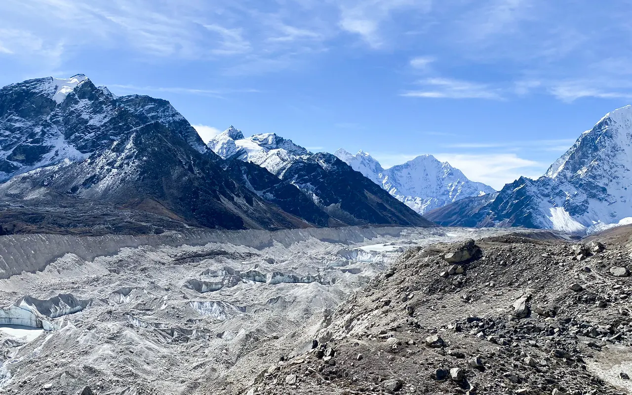
Then the trail is leveled and you travel along the Khumbu Glacier. Pumori is visible in the distance. Late in the afternoon, you reach Lobuche 4,940 m / 16,207 ft. You check into the lodge, have your dinner and go to bed.
Activity & Duration
5–6 hrs hikingHighest Altitude
4,940m / 16,207ft (Lobuche)Meals
Breakfast, Lunch and DinnerAccommodation
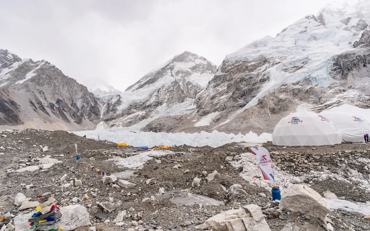
LodgeIt will be an extraordinary day because you have finally reach the Everest Base Camp today. You take the rocky path of the Khumbu Glacier after first having an early breakfast in Lobuche at 4,940 m / 16,207 ft. The trail has little high and low by broken moraine, and the elevation is so great that the walk is slow.
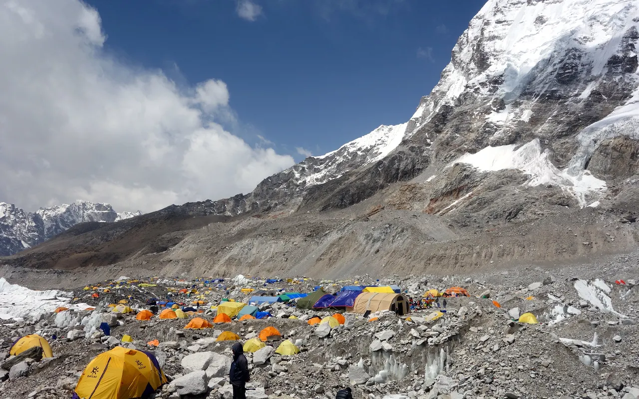
It takes approximately three hours to reach Gorak Shep at 5,170 m/ 16,962 ft, the final destination, which has lodges, lies in a cold and sandy valley bottom. You have lunch early and rest a little.
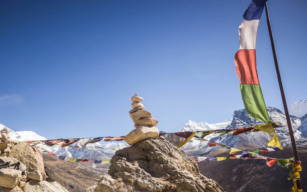
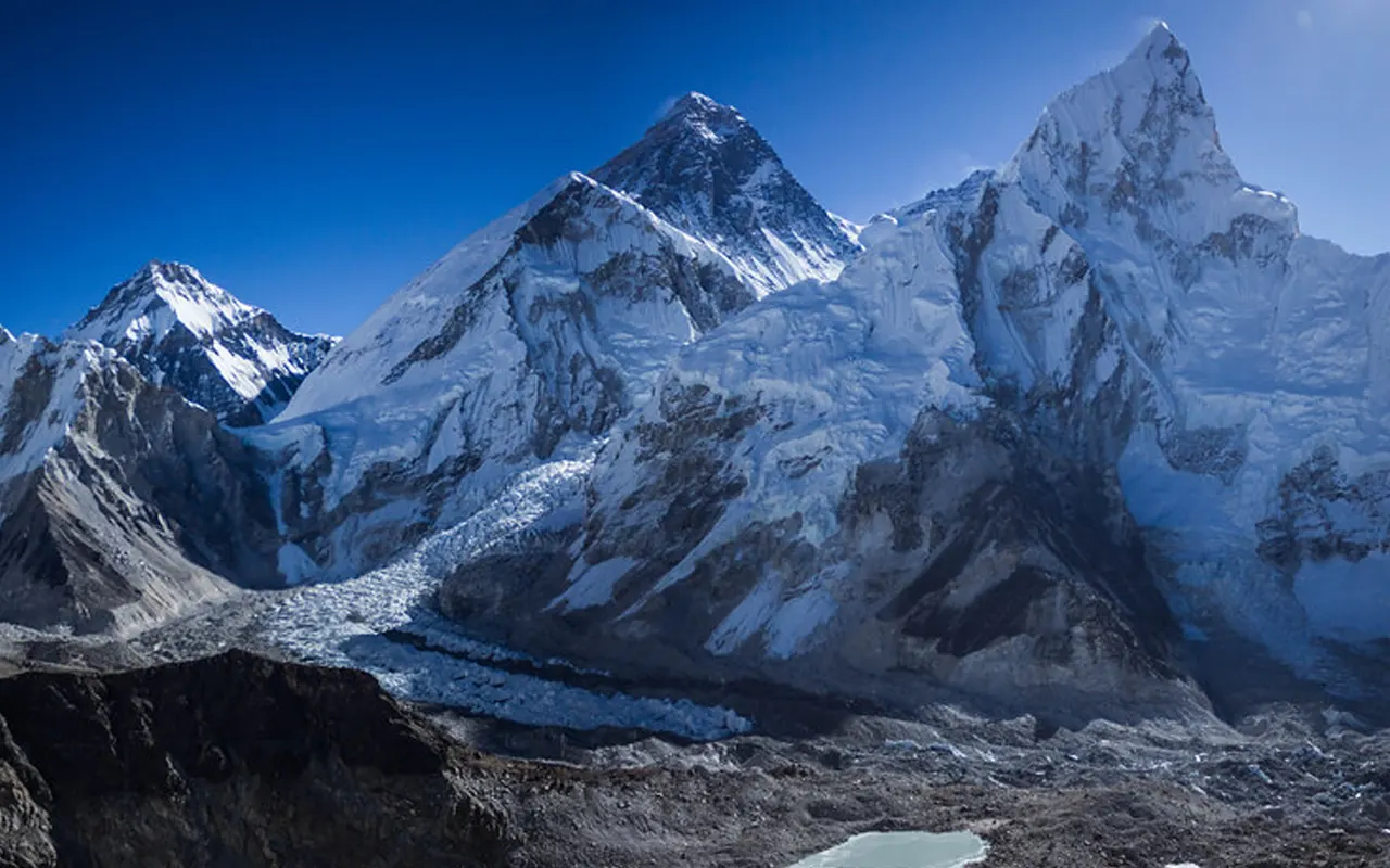
Then you leave your bag and keep on towards Everest Base Camp. The path is rugged, and it might be exhausting, yet the adventure keeps you going. You reach the Base Camp of Everest, 5,364 m / 17,598 ft., after 1.5-2 hours. You are next to the Khumbu Icefall and are proud of where you have got to. During climbing season, coloured tents can be found; otherwise, it is indicated by prayer flags and cairns of stone.
Take pictures, have fun and then take a walk back to Gorak Shep at 5,170 m / 16,962 ft to have dinner and sleep.
Activity & Duration
7–8 hrs hikingHighest Altitude
5,364m / 17,598ft (Base Camp of Everest)Meals
Breakfast, Lunch and DinnerAccommodation
TentYou rise early in the morning and start preparing to hike Kala Patthar. Using a headlamp and warm clothes, you begin climbing on a steep and rocky path. It is very thin air, and you move slowly and rest in between.
In approximately 1.5-2 hours, you arrive at Kala Patthar 5,545 m / 18,192 ft, which is the highest point of your trek. As the sun comes out, the mountains are gold and Mount Everest appears to be too close to believe. Nuptse, Pumori and the long Khumbu Glacier are also seen below.
You have your breakfast at Gorak Shep 5,170m/ 16,962ft after capturing photos and savouring the scenery. Then you strap and start down the valley. The trail passes over Lobuche at 4,940 m / 16,207 ft and Thukla at 4,620 m / 15,157 ft.
As you become lower in altitude, breathing becomes easier. In the afternoon, you get into Pheriche at 4,280 m / 14,042 ft, and can sit back in a warm lodge, and rejoice that you finally reached the Everest Base Camp successfully.
Activity & Duration
7–8 hrs hikingHighest Altitude
5,545m / 18,192ft (Kala Patthar)Meals
Breakfast, Lunch and DinnerAccommodation
LodgeIt is a long walking day today, but it is good, as the air grows thicker as you go down. On leaving Pheriche at 4,280 m / 14,042 ft, you make your way back up the valley of the Imja Khola. You overcome Pangboche at 3,985 m / 13,074ft and move to Debuche and the woods below.
The landscape appears elsewhere on the descent, and you might find greenery coming back. Eventually, you arrive at Tengboche 3,870 m / 12,697 ft. It is at Tengboche that you go down steeply to Phungi Thenga at 3,250 m / 10,663 ft and cross the river once more.
Then the path ascends slowly upwards to Namche Bazaar. Although it is a general downwards sloping path, the last uphill may be exhausting after several hours of walking. Then you end up in Namche Bazaar, 3,440 m / 11,286 ft., in the late afternoon, and you can relish the bakeries, stores, and a comfortable bed. An apple pie or a hot chocolate is a reward after spending days in the remote mountains.
Activity & Duration
7–8 hrs hikingHighest Altitude
4,280m / 14,042ft (Pheriche)Meals
Breakfast, Lunch and DinnerAccommodation
TeahouseYou are on your last day of the trek, and the feelings are mixed: glad, fatigued, and self-satisfied. The steep descent to the Dudh Koski River starts after you have breakfast in Namche Bazaar at 3,440 m / 11,286 ft. The rough steps may be painful to the knees, so trekking poles come in handy.
You are in Jorsalle, and then you pass Monjo at 2,835 m / 9,301 ft, leaving Sagarmatha National Park and registering out. The path goes along the milky river, over suspension bridges and through the well-known villages. You pass through Phakding 2,610 m / 8,563 ft and proceed to Chheplung 2,660 m / 8,727 ft.
It is a more crowded trail here, and there are plenty of trekkers heading in all directions. And, the last uphill climb is to Lukla at 2,840 m / 9,318 ft. It is a big accomplishment, as at this point, your trek ends. Say goodbye to your team by having a final dinner in the evening, recount the experience you had walking around, and celebrate the experience.
Activity & Duration
6–7 hrs hikingHighest Altitude
3,440m / 11,286ft (Namche Bazaar)Meals
Breakfast, Lunch and DinnerAccommodation
TeahouseIt is a short travel day today after days in the mountains. You wake up early in Lukla at an altitude of 2840m, 9318 ft and walk to the tiny airport. The airstrip of Lukla is known to be short, and it is surrounded by hills, hence the flight itself is exciting.
Once you are boarded, you fly in a small plane and take off over vast valleys and green ridges. The flight is normally 30 minutes, but the scenery may remain in your mind forever. You can see the Himalayan mountains in the distance one last time, through the window, fading out.
The scenery then shifts to hills, and then Kathmandu valley, which is bustling. After landing in Kathmandu, you change to your hotel. Air and temperature variation is also evident, and it is weird to be in a car and a crowd again.
And at last, you have a hot shower, a clean dress, and leisure. You can go out later, have a good meal in the city and rejoice at your successful trek. Although the adventure is complete, the experience of the Everest Base Camp and high points will remain with you for years to come.
Highest Altitude
2,840m / 9,318ft (Lukla)Meals
Breakfast, Lunch and DinnerAccommodation
HotelPrice Includes and Excludes
What is included?
- All necessary trek transport, such as personal drive from Kathmandu to Jiri/Shivalaya (or other trailhead), domestic flight from Lukla to Kathmandu and all airport transfers in Kathmandu.
- Two/three days stay in a standard 3-star hotel in Kathmandu with breakfast and teahouse stay with the trek on twin sharing basis.
- During the trek, three meals a day (breakfast, lunch and dinner)
- All the trekking permits and local entry charges,
- Well-trained English-speaking trekking guide and porters (usually one porter to two trekkers), their wages, food, lodging, insurance and gear.
- A duffel bag, a sleeping bag and a down jacket are provided at no charge when necessary (returnable after trek)
- Emergency evacuation coordination assistance in the event of necessity; safety assistance to a first aid kit carried by the guide.
- Briefing before the trek in Kathmandu, all the paperwork, government taxes, VAT and service fee.
- Welcome or farewell dinner in Kathmandu as mentioned on a particular package itinerary.
What is not included?
- Air travel to and out of Nepal, and the visa fee to Nepal.
- High-altitude trekking/ emergency evacuation travel insurance.
- Lunch and dinner in Kathmandu, except for the farewell or welcome dinner.
- Personal expenses like drinks, snacks, bottled water, alcohol and additional tea or coffee, hot showers, Wi-Fi, battery charging, and others.
- Individual trekking equipment, including boots, clothing, backpack, trekking poles and accessories.
- Tip for guides, porters, and drivers.
- Any other accommodation, meals or transport due to weather delay, sickness, or changes in itinerary.
- Emergency evacuation and medical expenses are required to be borne by personal insurance.
- Personal expenditures like souvenirs, laundry, phone, internet use in urban areas, optional tours, side trips or additional equipment rentals.
- Anything else not mentioned on the inclusion list.
Trip Information
Jiri To Everest Base Camp Trek Difficulty
Jiri to Everest Base Camp Trek is generally classified as moderate to strenuous since it is long with numerous steep ups and downs. You spend over two weeks walking on stone steps, through the forest and mountain.
In the initial part, you cross high passes such as Lamjura La 3530m/11581ft, which may seem exhausting even for fit trekkers. The positive side is that the slower rate of altitude gain is helping your body to adapt as compared to the short Lukla start.
This is not a trek that requires climbing; however, it requires good stamina and a stable attitude. The walking time is 5-7 hours per day, and after Namche, the thin air is felt. Even little hills are more difficult at 5,170 m / 16,962 ft, the highest sleeping point, Gorak Shep. Most first-time trekkers make it to the Base Camp of Everest with preparation, the appropriate pace, and assistance from the Himalayan Pathways.
Weather and Best Season
On the Jiri to Everest Base Camp Trek, the weather varies significantly as you go through hot hills and cold valleys. Spring (March-May) and autumn (late September-November) are the best seasons for this trek.
During spring, the lower villages are warm and flowery with rhododendron forests, whereas the higher regions, such as Dingboche at 4,410 m / 14,469 ft, are cold in the morning and evening. Spring can be exciting since there can be climbing teams and tents at the Everest Base Camp.
Autumn is also known for clear, mountainous, sharp views, particularly in October, but night is colder.
Monsoon (June-August) is not good since trails are muddy and slippery during the Jiri part due to rain, and clouds easily obscure the views. Winters (December-February) are quite chilly, and even the possibility of snow on the passes, such as Lamjura La, 3,530 m / 11,581 ft.
To the majority of trekkers, spring or autumn makes the Jiri to Everest Base Camp Trek the safest.
Food & Drink During the Trek
In the Jiri to Everest Base Camp Trek, the majority of meals are taken in teahouses, and the food is basic, hot, and substantial. The usual meal is dal bhat, rice, lentil soup and vegetables, and it is usually complemented with free refills, a good post-workday meal.
You will also have noodles, fried rice, soups, momos, potatoes and occasionally pasta or pancakes. The typical breakfast is porridge, eggs, toast, Tibetan bread or muesli. There is meat in lower locations, yet most of the trekkers opt to have vegetarian food after Lukla.
Soft drinks like black tea, milk tea, ginger-lemon-honey tea, coffee and hot chocolate are available. The higher you go, the higher the prices are, particularly around Gorak Shep, which stands at 5,170 m/16,962 ft.
In the case of water, boiled water in lodges is safer to use or treat the water yourself with purifying tablets. The guides at Himalayan Pathways can assist you in making safe choices; as a result, you would remain strong to the end of the Jiri to Everest Base Camp Trek.
Altitude Sickness and Suggestions
The Jiri to Everest Base Camp Trek has a real threat of altitude sickness because you are extremely high, such as the Everest Base Camp of 5,364 m / 17,598 ft and the Kala Patthar of 5,545 m / 18,192 ft. The Jiri is beneficial as you get up gradually, giving your body time to acclimatise.
Nevertheless, you have to walk slowly, consume plenty of safe water and eat adequately. The most frequently observed symptoms are a headache, fatigue, insomnia, and lack of appetite. Do not go higher, in case the symptoms get worse, such as vomiting, difficulty breathing at rest, confusion, or stumbling.
Resting or going down is the best remedy. Another question that is asked by many trekkers to their doctor prior to the trip is about Diamox. Himalayan Pathways guides will look out for warning signs and assist you in making a safe decision, hence you will be safe and have fun on the Jiri to Everest Base Camp Trek.
Preparation and Fitness
The Jiri to Everest Base Camp Trek would be a lot more fun with good preparation. You don’t need to be an athlete, but 8-12 weeks of preparation before your trip will make it easier. Focus on cardio-based activities, such as walking up hills or jogging, cycling, climbing stairs, and strengthening the legs and core. Go on hikes covering 5-6 hours with a daypack.
Mental preparation is important as the weather may change easily, you will have minimal facilities and hours of walking.
Break in your boots and take a few layers for warm layers. Consumption of water and healthy eating during training is important. Himalayan Pathways assists you with pacing, planning and local guidance. Through consistent training and a positive mind, the majority of individuals will successfully manage to undertake the Jiri to Everest Base Camp Trek without problems.
Visa and Permits
The correct visa and permits are required before the start of the Jiri to Everest Base Camp Trek. A Nepal tourist visa is usually issued to most of the visitors at Kathmandu on arrival, and carrying passport photos and cash is advisable.
Trekking permits needed for this trek are the Gaurishankar Conservation Area permit, Sagarmatha National Park entry permit and the Khumbu Pasang Lhamu Rural Municipality fee. Checkpoints along the path will require the presentation of such documents, particularly around Monjo before entering the park on the path to Namche at 3,440 m / 11,286 ft.
Keep permits dry and safe in a waterproof pouch. Himalayan Pathways will get you the permits prior to, so you need not waste time and stress in Kathmandu.
Having the documents prepared, you will be able to enjoy the villages, mountains and experience everything going on in the Jiri to Everest Base Camp Trek.
Health & Safety
The Jiri to Everest Base Camp Trek is health and safety conscious since you are walking long distances and reaching up to high altitudes. Use safe water: either boiled or purified, and wash hands frequently to prevent stomach troubles. Consume fresh and hot food and do not eat raw salads.
Wear sunscreen and sunglasses to protect yourself against the sun as UV is more intense at high altitudes, particularly near Gorak Shep at 5,170 m / 16,962 ft. The weather is unpredictable, and you should always have a waterproof jacket and warm layers in your bag.
Care about your feet and wear good socks, and treat the injured spots early before they can form a blister. In case you experience the signs of altitude sickness, inform your guide immediately.
You can enjoy the experienced support and the gradual pace plan with Himalayan Pathways, and this will reduce risk. The Jiri to Everest Base Camp Trek is safer and more enjoyable because of simple habits, which include hydrating, keeping clean, wearing layers, and listening to your body.
Transportation
Jiri to Everest Base Camp Trek begins with a lengthy road journey from Kathmandu to Jiri or sometimes up to Shivalaya/Bhandar, depending on the basis of the road conditions. The distance is approximately 187km, and it can be reached in 8-10hours traveling by bus or in a shorter time in a personal jeep.
Once at the trailhead, transportation becomes easy: it is simple to walk. In the primary trekking path, there are no roads until Lukla is reached. On the route, you will come across porters and pack animals carrying stores, whereas you will be making your way with your two legs. This gradual pace is one of the reasons why the Jiri to Everest Base Camp Trek is a unique experience, as you experience how the scenery is transformed day by day.
After the trek, you fly back to Kathmandu at an altitude of 2,840 m / 9,318 ft from Lukla. Weather can put a hold on flights, and it is prudent to have an extra buffer day. Himalayan Pathways assists in scheduling road transportation and air travel, and helps you navigate any kind of delay, thus making your journey hassle-free.
Travel Insurance
The Jiri to Everest Base Camp Trek is a trip that requires travel insurance since it will be very costly to evacuate from remote high-altitude regions. Your policy must explicitly include trekking above 5,000 m / 16,404 ft because the trail goes to Everest Base Camp at 5,364 m / 17,598 ft and Kala Patthar at 5,545 m / 18,192 ft.
Emergency medical care and helicopter evacuation are the most valuable cover as they may cost thousands of dollars in case of a serious injury or severe altitude sickness. Trip delay must also be covered, as flights between Lukla can be cancelled in case of bad weather.
Look carefully at the insurance policy, as certain standard policies have altitude restrictions unless you purchase an adventure upgrade. Always have a digital and a printed version of your insurance information, together with the emergency phone number.
Having the appropriate insurance, you are free to go to Jiri to the Everest Base Camp Trek without worry.
Alternative Routes
The Jiri to Everest Base Camp Trek is a classic overland trip, yet there are numerous alternative paths and extensions to suit the purpose.
Some prefer to trek from Jiri to Everest Base Camp and back by plane at Lukla, which is 2,840 m / 9,318 ft, which saves time on the way back.
Others cut the initial portion by taking a drive to Salleri or Phaplu and entering the route at Kharikhola, eliminating the number of days spent on the trek, but retaining some of the classic atmosphere.
For people who have additional energy and time, it is possible to include the Gokyo Lakes trail and cross Cho La Pass 5,420 m / 17,782 ft, which offers breathtaking views and is less crowded.
Side trips are also popular, such as the short hiking to Chhukung at 4,730 m / 15,518 ft.
Himalayan Pathways can make the Jiri to Everest Base Camp Trek suit your time, fitness and interest so that it comes out to be an authentic experience.
Your Extra Expenses
Some of the expenditures are not covered in the package during the Jiri to Everest Base Camp Trek, and it is hence worth planning. In Kathmandu, you buy your lunches and dinners. Drinks, snacks, bottled or boiled water, hot showers, Wi-Fi, and device charging are also extra on the trail.
The higher the altitude, the higher the prices; even tea and water are costly near Gorak Shep at 5,170 m / 16,962 ft.
A phone or a camera can also be very expensive to charge over a series of days. Another cost that is expected, and a show of appreciation to your guide and porter, is tipping them.
There is also a high rate of spending money on souvenirs in Namche Bazaar at 3,440 m / 11,286 ft. by many trekkers.
It is prudent to bring along adequate Nepali rupees in Kathmandu because the ATMs are not reliable beyond Kathmandu.
Language & Communication
The issue of language is not a major concern in the Jiri to Everest Base Camp Trek, particularly when one is trekking with the guide. In the lower Jiri part, Nepali is the local language; higher up in the Khumbu above Namche at 3,440 m / 11,286 ft., the Sherpa (a Tibetan-based language) is used more often, particularly in major trekking villages.
English is also used widely in lodges, shops and by guides. It is nice to learn some words such as Namaste (hello) and Dhanyabad (thank you), which are welcomed and generally result in smiling.
Mobile Network, Internet & Charging Facilities
The Jiri to Everest Base Camp Trek has poor connectivity, something that most trekkers find refreshing. In the Jiri part, cell phone coverage is minimal and can be found on high ridges frequently.
Once inside the Khumbu, basic phone connections are available in Lukla and Namche Bazaar at 3,440 m / 11, 286 ft; primarily with Nepal Telecom. The internet is mostly available in the form of Everest Link Wi-Fi in lodges above Namche, such as Dingboche at 4,410 m / 14,469 ft and Lobuche at 4,940 m / 16,207 ft, but it is slow.
Phones and cameras can be charged at a fee in the dining halls, and electricity is usually free and sourced through solar power.
It is quite convenient to carry a power bank, and this is particularly useful once around Gorak Shep with a height of 5,170 m / 16,962 ft. Expect little connectivity once you’re on the Everest Base Camp Trek.
Don’ts on This Trip
The Jiri to Everest Base Camp Trek has a couple of significant rules that one can follow without breaking. Be not in haste, or competition with others, because you must go slow, steady up-hill.
Consumption of alcohol or smoking in high altitudes, such as Dingboche at 4410 m / 14469 ft, aggravates the symptoms of altitude. Altitude sickness can be easily missed; it is always safer to go down than to continue on.
Do not litter and bring all rubbish along, and save the mountains. Respect local culture by going clockwise around mani stones and take off your shoes in monasteries, including Tengboche on 3,870 m / 12,697 ft. level.
Do not walk alone at night or outside the main trail without notifying your guide. Avoid taking pictures of people without their consent. Himalayan Pathways focuses on these few guidelines in order to make the Jiri to Everest Base Camp Trek a pleasant and responsible experience among the trekkers.
Trip Extension
Having completed the Jiri to Everest Base Camp Trek, a lot of people decide to spend more time in Nepal. It is a common activity to spend a couple of relaxing days in Kathmandu and enjoy heritage sites and recovery massages.
Other places of interest include Pokhara, which has lakeside and warmer weather, as opposed to Everest Base Camp, and wildlife lovers can be taken to the Chitwan National Park, where they can go on jungle safaris and see the rhinos.
Those with additional time and funds can find a trip to Bhutan or Tibet to offer additional cultural experiences. You can even opt to go on another short trek, such as Poon hill as a means of rest.
These extensions will enable your body to rest and see another face of Nepal. Himalayan Pathways would be able to take care of your post-trek arrangements to ensure that you keep on with the journey.
Frequently Asked Questions
What is the duration of the Jiri to Everest Base Camp Trek?
The trek lasts approximately 17-19 days based on the schedule and itinerary.
What is the difficulty level of the Jiri to Everest Base Camp Trek?
The trek is classified as moderate to challenging because it is very long, steep uphill and mountainous.
What is the highest elevation in the trek?
Its peak is Kala Patthar, and it has an elevation of approximately 5,545 m / 18,192 ft.
Is there any prior trekking experience required for this trek?
Some previous experience in a multi-day trek is good but not mandatory, provided that you are physically fit and well prepared.
What is the best time to go to the Everest Base Camp Trek?
Spring (March-May) and autumn (September-November) are the most favourable times of the year to have a stable climate and clear skies.
Is altitude sickness an issue during this trek?
The high-altitude sickness may occur, but it is better to be acclimatised gradually due to the slow ascent of Jiri.
What kind of accommodation do we get during the trek?
You will stay in simple yet hygienic teahouses with twin rooms.
Should the Jiri to Everest Base Camp Trek have permits?
There are a few trekking permits and local entry charges which are required and have to be carried along on the trek, but we get all the permits for you, and they are included in the package.
Do I need to have travel insurance for this trek?
Yes, the high-altitude trekking and emergency evacuation travel insurance is much needed.
Is it possible to tailor the itinerary of this trek?
Yes, the itinerary can normally be tailored according to time, fitness, and individual preferences.
Reviews on Jiri to Everest Base Camp Trek
- Your safety, our priority
- Best price guarantee
- Experienced & dedicated team
- Easy booking, no hidden charge
- You can customize this trip