Duration
15 Days
![]() Unbeatable Holiday Offers - Save Up to 20% on Your Next Adventure!
Unbeatable Holiday Offers - Save Up to 20% on Your Next Adventure!
Lower Dolpo Circuit Trek – 15 Days
Trip Difficulty
ModerateMax. Altitude
5289 MetresGroup Size
2-20 PeopleBest Season
Mar-May, Sep-NovTransportation
FlightAccommodation
Teahouse, HotelMeals
Breakfast, Lunch and Dinner- Your safety, our no 1 priority
- Best price guarantee
- Experienced & dedicated team
- Easy booking, no hidden charge
- You can customize this trip

Trip Overview
The Lower Dolpo Circuit Trek is one of the most unique and remote trekking adventures in Nepal. This trek is situated in the western Himalayas, and it goes through the Dolpo region, which is a beautiful and culturally varied place.
As compared to most of the well-known trekking trails in Nepal, the Lower Dolpo region is undisturbed and less populated, which gives trekkers an opportunity to witness the untouched scenery and the traditional mountain living. The trip provides an ideal mix of nature, culture, and real wilderness. green valleys and thick forests, to dry mountain ranges and high mountain passes. With each day of the Lower Dolpo Circuit Trek, we have a new and very memorable experience.
The trek normally starts with a flight from Kathmandu to Nepalgunj and another short flight to Juphal, which is an entry point to the Dolpo region. It is here that one can get into the large and breathtaking Shey Phoksundo National Park, which is the biggest national park in Nepal. This wildlife reserve has an elevation ranging between 2,130 m / 6,988 ft and 6,885 m / 22,588.5 ft, providing a great deal of landscape and wildlife.
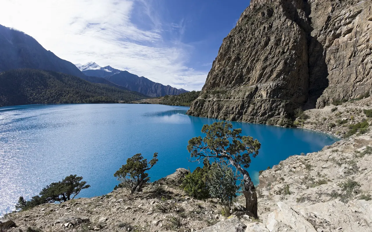
Trekkers will traverse isolated villages like Dho Tarap, cross by rivers and suspension bridges, and pass across yak grazing fields and pine forests. The spectacular Phoksundo Lake, the deep turquoise-hued lake at the corner of the Dolpo, is one of the key attractions of the Lower Dolpo Circuit Trek.
The Lower Dolpo Circuit Trek allows trekkers to experience the most distinctive cultural heritage of the Dolpo region, where daily life is strongly influenced by Tibetan traditions. Several local communities strictly adhere to Tibetan Buddhism, and there are a few local communities practicing the ancient religion of Bon.
There are stone houses, prayer flags, monasteries, and traditional lifestyles, which provide the visitors with a peep to an unaltered way of life that has not been changed in centuries. The trek also provides the opportunity to observe wildlife in the form of blue sheep, musk deer, and even a rare animal, the snow leopard, in the national park.
The Lower Dolpo Circuit Trek is a memorable experience for the traveler who would like to see an isolated part of the Himalayas where the scenery is truly spectacular, and the culture is rich. Through proper planning, highly skilled guides, and good logistics, Himalayan Pathways has made this adventure enjoyable so that the trekkers are able to experience one of the best trekking experiences in Nepal.
Highlights of Lower Dolpo Circuit Trek – 15 Days
- Explore the remote beauty of western Nepal, with no congested trekking trails.
- See the beautiful turquoise waters of the Phoksundo Lake (3,612 m 11,850 ft), one of the most beautiful lakes of the Himalayas.
- Hike in Shey Phoksundo National Park, which is the largest national park in Nepal.
- Cross dramatic Himalayan passes at a height of 5,000 m /16,404 ft, with exquisite mountain scenery.
- Explore the village of Dho Tarap, which is one of the highest settlements in the area.
- Explore the Tibetan-inspired culture, such as Buddhist monasteries and the ancient Bon religion.
- Cross various scenery, including green woods and streams, as well as arid alpine valleys and yak fields.
- See rare Himalayan wildlife, such as blue sheep, musk deer, and even the very elusive snow leopard.
Lower Dolpo Circuit Trek – 15 Days Itinerary
You will start your trip in Kathmandu, where your guide will pick you up from your hotel and drive you to the domestic terminal of Tribhuvan International Airport. It is a short flight, of about 50 minutes, from here to Nepalgunj. In the flight, you will have an opportunity to see the plains and the distant hills of Nepal. Nepalgunj is in the Terai at an altitude of 150 m/ 492 ft, near the Indian border.
The culture of the city is very different than that of the Himalayan regions that will be visited afterwards on the trek. The weather is warmer, and the lifestyle is exposed to the local Indian influence.
Once there, you will check into your hotel, and you will find you have some leisure time to walk through the town. You can go to local markets, little temples, and streets, and then have dinner by yourself. Go to bed early this evening because your walking trip starts tomorrow.
Activity & Duration
Flight from Kathmandu to Nepalgunj and city explorationHighest Altitude
150m / 492ft (Nepalgunj)Meals
Breakfast, Lunch and DinnerAccommodation
HotelIn the morning, you have a picturesque 45-minute flight between Nepalgunj and Jhupal. The tiny mountain airstrip is surrounded by green hills. Jhupal is where you meet your porters and trekking staff, where you have a cup of tea and a light snack, and prepare to make your first hike in the journey.
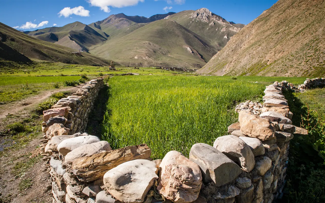
The path starts with a hike over the Thulo Bheri Valley. You pass through the cultivated fields and small village settlements where the village people lead simple lives in the mountains. On passing the village of Kalagaunda, you move on in a path that gets you to Roop Ghar, where you get to see a traditional water mill.
The road then leads to the river until Dunai at 2,850 m / 9,350 ft, the headquarters of the Dolpo region. Once here, rest and have a view of the serene mountain.
Activity & Duration
Flight to Jhupal and trek to Dunai, 3 hrs hikingHighest Altitude
2,850m / 9,350ft (Dunai)Meals
Breakfast, Lunch and DinnerAccommodation
TeahouseFollowing breakfast, you start walking up and down the banks of the Thulo Bheri River. The trail is in the valley of the river and has very stunning views of the hills and forests around. As you go, you will go over the river crossing wooden bridges and winding paths. The trail moves through a deep ravine and over a small hill.
You arrive at the town of Lawan and cross the river again. Here, the trail is making its slow way to the village of Tarakot (2,543 m / 8,343 ft), which has some cultivated fields and relics of an ancient kingdom. Close to the village, one can see the ruins of an ancient fortress that used to defend this area.
Upon reaching your tea house, you can take a walk around the village to see how people in the area live, then you can have dinner and get a good sleep.
Activity & Duration
Trek from Dunai to Tarakot, 6 hrs hikingHighest Altitude
2,543m / 8,343ft (Tarakot)Meals
Breakfast, Lunch and DinnerAccommodation
TeahouseThe walk proceeds with Tarakot left behind after breakfast, in the valley of the Bheri River. It follows a path that, at first, crosses the river to the southern side, but then ascends gradually through a series of terraced farmland where there is the cultivation of crops such as buckwheat. On the elevated parts of the road, one may have a panorama of the river running several feet below.
In the afternoon, you come down to pass by a long suspension bridge at Laisicap. Before the bridge, you have to present your trekking permits at a check post. The trail then ascends again after the bridge to the village of Kanigaon. Here, the road turns into a wooded part in which the valley narrows and grows more impressive.
In the afternoon, you get to Laini (3,160 m 10,367 ft), a meadow rather than a village. Mule caravans that go through the area usually use this place as their seasonal overnight spot.
Activity & Duration
Trek from Tarakot to Laini, 6 hrs hikingHighest Altitude
3,159m / 10,364ft (Laini)Meals
Breakfast, Lunch and DinnerAccommodation
TeahouseThe trek continues further into the Dolpo area after having an early breakfast. The path leads gradually on to a mountain pass at 3,540 m / 11,614 ft, adorned with colorful Buddhist prayer flags. It is the flags that are fluttering in the wind, and they indicate the spiritual significance of the pass.
Once we get to the peak, we’re heading back down to another river called Chyugar Khola. A hanging bridge helps in getting across safely before the trail proceeds through rocky trails and open territories. On your way, there are seasonal huts in the Tazam area where the herders of the local animals remain during warmer weather.
The trail has another suspension bridge leading to the last stretch to Nawar Pani at 3,545 m / 11,630 ft. At this increased altitude, one should keep themself hydrated and walk at a slow pace to enable their body adapt to the reduced air.
Activity & Duration
Trek from Laini to Nawar Pani, 5 hrs hikingHighest Altitude
3,545m / 11,631ft (Nawar Pani)Meals
Breakfast, Lunch and DinnerAccommodation
TeahouseThis is the longest trekking day of the entire Lower Dolpo Circuit Trek. You cross the river again after breakfast and then take a narrow path hacked out of the side of a cliff. The trail provides the spectacular scenery of deep valleys and steep mountains of Dolpo.
The next part of the climb is characterized by a chorten, a small shrine, demonstrating Tibetan Buddhist culture in the area. This is known as Serkam and used to be a former border post linking Nepal and Tibet.
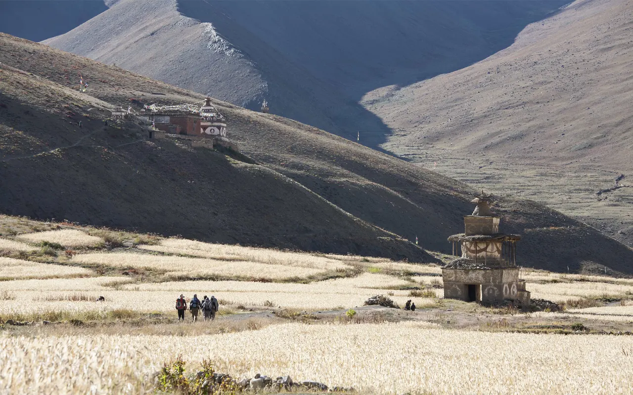
Out of here, the road leads off into a large valley, over which you get a view of the village of Dho Tarap. Dho Tarap elevation is 4,090 m/ 13,418 ft and is among the highest enduring communities in Nepal. The village gained fame following the feature in the film Himalaya by Eric Valli.
Activity & Duration
Trek from Nawar Pani to Dho Tarap, 7 hrs hikingHighest Altitude
4,090m / 13,419ft (Dho Tarap)Meals
Breakfast, Lunch and DinnerAccommodation
TeahouseWe will today spend a significant rest and acclimatization day at Dho Tarap and take more time to in this area to acclimatize your body to the high altitude before proceeding any further up the mountains. You will have more time to sleep, have a nice breakfast, and take in the scenic mountain air.
The village can be visited during the day, and the local culture can be learned. There is a Bon monastery approximately a half hour away. Bon is a pre-Buddhist religion of Tibet, which existed before Buddhism became widespread in the state. The monastery of Bon provides a good comparison to the Buddhist monastery found within the village.
You can also go on a tour of the fields and mingle with the locals who are of traditional lifestyles in this remote region. This is a beautiful spot to rest and recover, surrounded by the mountains and a wide valley.
Activity & Duration
Acclimatization and cultural exploration in Dho Tarap, 2 hrs hikingHighest Altitude
4,089m / 13,415ft (Dho Tarap)Meals
Breakfast, Lunch and DinnerAccommodation
TeahouseAfter breakfast, you start walking along Dho Tarap heading to the greater heights of the alpine landscape. The path goes to the top of Mekyem Gompa, which is where a huge statue of Maitreya Buddha can be observed. This monastery offers a serene spot where one can stop and have a glimpse of the mountains around.
Going on the path, you arrive at Dorje Phurba Gompa, which is famed for its possession of ancient weapons and religious objects. The Crystal Mountain School, the biggest school in this inaccessible region, is on the path as well.
The road further passes a bridge into the Tarap Chu River close to the small village of Mondo, made of wood. Going through some other minor villages, the road ascends continuously until it gets to the Numa La Base Camp at 4,440 m / 14,566 ft. This camp is located in a steep mountain setting, and it will prepare you for the tough passes to come.
Activity & Duration
Trek from Dho Tarap to Numa La Base Camp, 6 hrs hikingHighest Altitude
4,440m / 14,567ft (Numa La Base Camp)Meals
Breakfast, Lunch and DinnerAccommodation
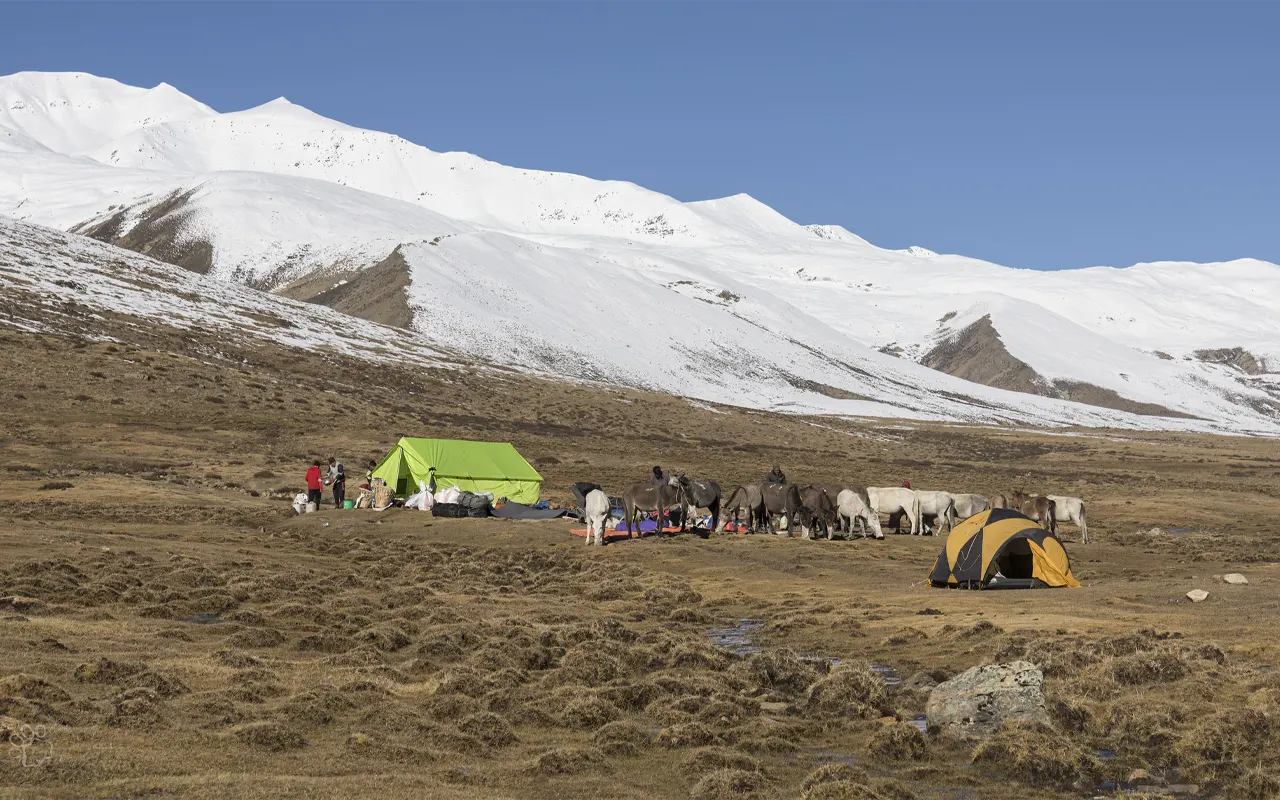
TentIt is one of the most thrilling and difficult days of the trek today. You start climbing the high Numa La Pass after breakfast in the Numa La Base Camp. It is a steep and rough trail that has rocky terrain with a lot of moraines; thus, one has to be careful in taking steps. The closer and closer you reach the altitude, the more dramatic the surrounding landscape and the more the views of the mountains start to open up.
One of the highest points of the trek is the Numa La Pass, which is 5,290 m / 17,355.6 ft. At the top, you can see some of the mountains such as Dhaulagiri at 8,167 m / 26,794.6 ft, Shey Shikhar at 6,139 m / 20,141 ft, and Kanjeralwa at 6,612 m / 21,693 ft.
Once you have had your sightseeing, you go down cautiously through a broad U-shaped valley, and there is scree. The path eventually ends in the beautiful pastureland of Pelung Tang at 4,465 m / 14,648 ft.
Activity & Duration
Trek from Numa La Base Camp to Pelung Tang via Numa La Pass, 6 hrs hikingHighest Altitude
5,290m / 17,356ft (Numa La Pass)Meals
Breakfast, Lunch and DinnerAccommodation
TeahouseThe trail leaves the calm pasture of Pelung Tang with a slow, gradual climb on a winding trail. You follow a series of switchbacks that lead toward a place called High Camp. The scenery of this place is rough and exposed with mountain slopes and rocky terrains at high levels.
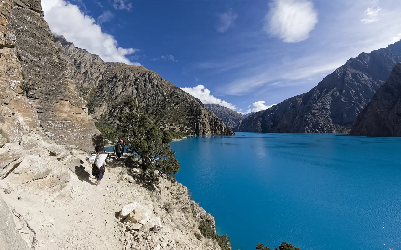
At High Camp, the path runs onto a ridge and then over several rock slopes. You lastly get Baga La Pass, which is 5,175 m / 16,978.3 ft by walking attentively over the loose stones. The high point in the pass is marked by sacred chortens and colored prayer flags. The perspective here is magnificent. The beautiful Phoksundo Lake is visible far below, and Norbung Kang peak, which is impressive, measuring 6,085 m / 19,963.9 ft.
The trail then leads down to a wide valley, after viewing the scenery. You pass over mild slopes until you arrive at the campground at Dajok Tang at 4,080 m / 13,385 ft.
Activity & Duration
Trek from Pelung Tang to Dajok Tang via Baga La Pass, 6 hrs hikingHighest Altitude
5,175m / 16,978ft (Baga La Pass)Meals
Breakfast, Lunch and DinnerAccommodation
TeahouseThe walk today is not so long and is more comfortable as you are heading down to the gorgeous Phoksundo Lake region. The trail moves on after breakfast at Dajok Tang at 4,080 m / 13,385 ft and travels through open alpine country where seasonal herders occasionally keep their animals.
The scenery progressively alters as you descend to a big valley where there are pine and juniper woods. The path follows easy gradients, and after a short distance, you get into a ridge where you can observe a magnificent waterfall. Here you head down through pine woods to the village of Ringmo at 3600 m / 11811 ft.
Ringmo is a remote village with stone houses and fields where locals cultivate barley. Here, your trekking permits are verified, and you head off to the gorgeous turquoise waters of the Phoksando Lake at an altitude of 3,612 m / 11,850 ft. After lunch, you can visit the village, see the special architecture and lifestyle of the local Dolpo people.
Activity & Duration
Trek from Dajok Tang to Ringmo and Phoksundo Lake, 4 hrs hikingHighest Altitude
4,080m / 13,386ft (Dajok Tang)Meals
Breakfast, Lunch and DinnerAccommodation
TeahouseIt is a restful acclimatization day today in the gorgeous Phoksundo Lake, at an altitude of 3,612 m / 11,850 ft. This rest day is after a few difficult days of walking through the mountain passes, which are very high in elevation, so that your body is able to rest as you have a chance to relax in the serene atmosphere.
In the morning time you may take a leisurely breakfast and look over the clear turquoise waters of the lake. The cliffs and forests around, and the snow-capped mountains, make a very serene and picturesque scene. A large number of trekkers are fond of yoga, meditation, or a well-deserved rest by the shore of the lake.
The famous 1999 movie titled Himalaya by Eric Valli made it to Phoksundo Lake and the neighboring village of Ringmo. The movie narrates the story of the Dolpo villagers who walk the mountain ranges with the caravan of yaks that carry salt to exchange for grain. The film featured a lot of local individuals in the area and served to bring the traditional life in the mountains to the world.
Activity & Duration
Rest Day and exploration around Phoksundo Lake, 2 hrs hikingHighest Altitude
3,612m / 11,850ft (Phoksundo Lake)Meals
Breakfast, Lunch and DinnerAccommodation
TeahouseHaving taken time to appreciate the serene atmosphere of Phoksundo at 3,612 m / 11,850 ft, it is time to start moving out of the Dolpo region. Leaving the lake, you take a steep path which brings you to the summit of a hill. It is a good viewpoint to get one final glimpse of the lovely turquoise waters of the lake below.
Having observed the sight, the trail starts to fall into the woods and little villages. You drive through the villages of Chunuwar and Rechi, which might have traditional homes and small farms that households are using.
The path follows the river valley downhill and is a pleasant one, leading to Chepka. It is a short walk there to your overnight destination, Shyanta, which is at 2,520 m / 8,267 ft. This is a pleasant place to rest after trekking in the high mountains, as the air is lower and the surroundings are greener.
Activity & Duration
Trek from Phoksundo Lake to Shyanta, 4 hrs hikingHighest Altitude
3,612m / 11,850ft (Phoksundo)Meals
Breakfast, Lunch and DinnerAccommodation
TeahouseThis is your last day on your Dolpo adventure. You change your direction from Shyanta, at 2,520 m / 8,267 ft., and resume the route you followed the previous day, heading to Jhupal. It is situated along the river valley and through the green hills, small villages, and farmlands.
Then, as you walk further down the trail, you will find how the landscape gradually alters to include more settled land as opposed to distant mountainous terrain. You may always find the local people in the fields working or walking along the ways between the villages.
You arrive eventually at Jhupal at 2,320 m / 7,611 ft, the main access point to the Dolpo region. Numerous trekking paths in Dolpo start and end here. There are some small stores and tea houses in Jhupal where trekkers usually unwind after their trip. In the evening, you can celebrate the successful trek and say goodbye to your trekking crew.
Activity & Duration
Trek from Shyanta to Jhupal, 5 hrs hikingHighest Altitude
2,520m / 8,268ft (Shyanta)Meals
Breakfast, Lunch and DinnerAccommodation
TeahouseThis is the last day of your Lower Dolpo Circuit Trek. You have breakfast in Jhupal and then take a flight back from the small mountain airport. The Jhupal to Nepalgunj flight has great air views of the rugged hills and valleys of western Nepal.
Once you get to Nepalgunj, you take another flight that will lead you back to Kathmandu. As you head towards the journey, you might get your last glimpse of the western Himalayas, such that the amazing sceneries that you have experienced throughout the trek.
The city of Kathmandu is located at an elevation of 1,300 m / 4,265 ft and is a vibrant place after the serene mountain roads. When you get there, you transfer to your hotel to relax and contemplate your adventure, as well as spend time resting in the city after several days in the woods.
Activity & Duration
Flights from Jhupal to Nepalgunj and Kathmandu, 2 hrs hikingHighest Altitude
2,320m / 7,612ft (Jhupal)Meals
Breakfast, Lunch and DinnerAccommodation
HotelPrice Includes and Excludes
What is included?
- Kathmandu Airport transfers
- Domestic flights according to the itinerary
- One night stay in Nepalgunj hotel and tea house in Juphal according to the itinerary.
- Tent accommodation in the Lower Dolpo Circuit Trek.
- All the food on the trek (Breakfast, Lunch, Dinner) with tea, coffee, and boiled drinking water.
- Professional English-speaking trekking guide salary, accommodation, meals, insurance, and permits.
- The support staffs such as camp chefs and porters, depending on the number of people, include their wages, accommodation, meals, insurance, and transport.
- All the camping gear, such as tents, a kitchen tent, a dining tent, and a toilet tent.
- Lower Dolpo and Shey Phoksando National Park permit is a Restricted Area Permit (RAP).
- The guide has a first aid kit.
- All taxes and official services of the government.
What is not included?
- Nepal tourist visa and airfare to and from Nepal.
- Travel insurance (obligatory; has to include high-altitude trekking above 5,000 m / 16,404 ft and emergency evacuation by helicopter).
- Kathmandu Hotel accommodation and meals before the trek and after the trek.
- Personal medical supplies and personal trekking equipment.
- Individual expenses like snacks, bottled drinks, internet, phone calls, laundry, and charging where necessary.
- Donations at monasteries and cultural sites.
- Added expenses because of the delay of flights, weather conditions, changes to the itinerary, or unexpected events.
- Guide, chef, and porter tips.
Trip Information
Difficulty Level
Lower Dolpo Circuit Trek is an adventure that is average in difficulty and is located in the remote Himalayas in the western part of Nepal. It is not as strenuous as some of the Dolpo trails, although it needs one to be in good physical health and have experience in trekking. The trek typically takes about two weeks and involves several long walks over forest, rivers, dry valleys, and alpine pastures.
The altitude is one of the primary obstacles of the Lower Dolpo Circuit Trek. The trekkers usually sleep at an elevation higher than 3,500 m / 11,482.9 ft, and some mountain passes along the route are above 5,000 m / 16,404 ft.
Due to such high altitudes, Himalayan Pathways makes the itinerary very meticulous by including acclimatization days and a gradual pace. When adequately equipped, well directed, and determined, most trekkers can complete this trek with a lot of pleasure, viewing the magnificent scenes of the Dolpo region.
Weather and Best Season
The climate in the location of the Lower Dolpo Circuit Trek is very dissimilar to other trekking places in Nepal. Dolpo is located in the rain shadow of the Himalayas, which implies that it does not get much precipitation during the monsoons. Owing to this special climate, trekking here can be done throughout most of the year except the cold winter season.
Spring and autumn are the most favorable seasons for the Lower Dolpo Circuit Trek. The spring normally spans between April and May, when the atmosphere becomes warmer since winter is over, and the skies tend to be clear. Another terrific period is during autumn, which falls between mid-September and the end of October, when the mountain scenery is most beautiful.
The trek goes through Shey Phoksundo National Park with an altitude from approximately 2,130 m / 6,988 ft to 6,885 m / 22,588.5 ft. Due to such a great elevation difference, the temperature may vary rapidly. Carry warm clothes and any other equipment necessary to deal with cold mornings and evening in the trek.
Foods and Drinks
The food in the Lower Dolpo Circuit Trek is simple, nutritious, and freshly cooked by the trekking staff. Himalayan Pathways uses the trek as a camping trip; the camp chef will cook the food in a kitchen tent, and trekkers will be accommodated in cozy camping tents. Breakfast and dinner will be at the campsite, and lunch will be on the trail as the trek goes on.
The standard breakfast is porridge, bread, and occasionally roti, a Nepalese flatbread. Lunch and dinner may contain pasta, noodles, pizza, or dal bhat, one of the common Nepalese meals, cooked with rice, lentils, and vegetable curry. It is also common to have afternoon snacks such as fried potatoes or popcorn.
Hot beverages like tea, coffee, and boiled water are provided throughout the trek. As trekkers tend to sleep at altitudes higher than 3,500 m / 11,482.9 ft in the course of the Lower Dolpo Circuit Trek, avoid alcohol and keep yourselves well-hydrated, energized, and healthy.
Altitude Sickness and Recommendations
Another factor that should be considered when doing the Lower Dolpo Circuit Trek is altitude sickness, since the route covers a number of high mountain areas. Trekkers frequently camp above 3,500 m / 11,482.9 ft, and a few of the passes on the path go above 5,000 m / 16,404 ft. At such heights, the oxygen in the air is also low, and it can cause headache, dizziness, fatigue, or even nausea.
Himalayan Pathways pays attention to the itinerary to minimize the risk of getting altitude sickness, having acclimatization days, and a slow increase in altitude. On the trek, the guides advise the trekkers to move at a slow pace, consume as much water as possible, and have frequent rests.
Trekkers are advised to pay attention to their bodies and report any symptoms to the guide in case they are unwell. Through the recommendation of the guide and a slow pace, a majority of the trekkers can safely experience the Lower Dolpo Circuit Trek and acclimatize easily to the high Himalayan conditions.
Preparation and Fitness
The Lower Dolpo Circuit Trek requires proper preparation and fitness. You should get good stamina prior to their arrival in Nepal. The walk is typically between 6-8 hours daily on average, which have few longer days based on the trail conditions and elevation.
The trekkers are advised to be ready by engaging in routine physical exercises like jogging, cycling, or walking long distances. The tightening of leg muscles and cardiovascular fitness will help the trek to be more comfortable and enjoyable. Physical preparedness is particularly relevant as the road goes through mountain passes (above 5,000m / 16,404 ft) and spending the night above 3,500 m / 11,482.9 ft.
Proper gear is also necessary, besides fitness. Carry warm clothes, a good sleeping bag, a good trekking boot, and some basic medical aid.
Mental conditioning is also a plus, as the Lower Dolpo Circuit Trek is set in isolated locations, where patience, stamina, and a positive mind are likely to make the trip more fulfilling.
Visa and Permit
Trekkers have to obtain a Nepal visa and other trekking permits before they start the Lower Dolpo Circuit Trek. A Nepal visa is accessible to most travelers on arrival at Tribhuvan International Airport in Kathmandu. The visa will be granted a 15-day, 30-day, or 90-day visa based on the traveler’s plans.
Along with the visa, the Lower Dolpo Circuit Trek also needs special permits since the area is restricted, and it is a part of the Shey Phoksundo National Park. These permits are arranged in advance by Himalayan Pathways for the trekkers.
The permits required are the Restricted Area Permit of Lower Dolpo and the Shey Phoksundo National Park permit.
The Shey Phoksundo National Park encompasses an area with heights of 2,130 m / 6,988 ft to 6,885 m /22,588.5 ft. The permit fees assist in safeguarding the wildlife in the park and support the culture of local people.
Health and Safety
The Lower Dolpo Circuit Trek places great emphasis on health and safety due to the fact that the route is located in remote mountainous areas. Himalayan Pathways offers experienced guides who are aware of difficulties faced during trekking at high altitude and how to react to crises.
Trekkers commonly camp over 3,500 m / 11,482.9 ft, and the trek has high passes, which exceed 5,000 m / 16,404 ft, so they need to take suitable precautions. Move slowly, drink plenty of water, have frequent meals, and have sufficient rest during the trek. Guides observe the trekkers with altitude sickness symptoms and offer help where necessary.
Personal medicines, a small first aid kit, and travel insurance against high altitude trekking should also be carried by the trekkers. It is a safety measure to follow the instructions of the guide and stay in the group. Under proper planning and the guidance of the experts, the Dolpo Circuit Trek can be a safe and enjoyable adventure.
Transportation
The Lower Dolpo Circuit Trek has a combination of trekking and flights as transportation. Himalayan Pathways makes all the required travel in Nepal and allows the journey to be comfortable and easy. The journey normally starts at Kathmandu, where trekkers fly a domestic flight to Nepalgunj in western Nepal.
Another transportation involves a short flight that can carry trekkers from Nepalgunj to Juphal, which is the primary entrance to the Dolpo region. Juphal is the mountain that is the point of beginning the Lower Dolpo Circuit Trek. Here, the road goes on foot through villages, woods, rivers, and mountainous terrain.
After completing your trek through Shey Phoksundo National Park, we arrange return flights to Nepalgunj and Kathmandu, bringing this spectacular Himalayan journey to a close.
Travel Insurance
The Lower Dolpo Circuit Trek highly depends on travel insurance, as the trek will proceed in the remote part of the Himalayas. The trek consists of several days of long walks and isolated campsites, mountain passes, and many nights above 3,500 m / 11,482.9 ft. Due to this elevation, trekkers should be insured on high altitude trekking insurance and emergency evacuation insurance.
Helicopter rescue, as well as medical treatment, trip cancellation, and flight delays should be covered in your insurance policy. Weather conditions can occasionally cause flights to Juphal to be delayed; the insurance gives the added security.
Through adequate travel insurance, trekkers are able to have a good time and adventure, knowing that they are insured in this isolated Himalayan trek.
Alternative Routes
The trek starts from Kathmandu, Nepalgunj, and Nepalgunj to Juphal, which is an entry point to the Dolpo Valley. The trail traversing Juphal leads to the Shey Phoksundo national park, which is then traversed by the traditional villages like the Dho Tarap, before one finds the renowned Phoksundo Lake. The path finishes off the circuit by taking the same path back into Juphal.
This is the primary path, but Himalayan Pathways can change the itinerary as per the weather conditions, speed of trekking, or acclimatizing. Because the trek will visit mountain passes above 5,000 m / 16,404 ft and camp above 3,500 m / 11,482.9 ft, at times, guides will introduce rest days or modify the trail route a bit more safely. Such minor changes enable the trekkers to have a comfortable time in the Lower Dolpo Circuit Trek and yet have the same view of the forests, rivers, alpine fields, and the spectacular Himalayan landscapes.
Your Extra Expenses
When you make a booking with Himalayan Pathways, most of the great expenditures of the Lower Dolpo Circuit Trek are covered. It is usually organized beforehand, including transportation, camping shelter, lunch on the hike, guides, porters, and permits. Nevertheless, trekkers are not left without incurring certain personal expenses on the trip.
A typical additional cost is the gifts at monasteries or gompas on the way. People are used to making a small donation when visiting these religious places.
You can also consider carrying a few dollars for snacks, local small things, or beverages in such places as Nepalgunj before or after the trek. Since the majority of nights, one has to spend above 3,500 m / 11,482.9 ft, it is convenient to pack some personal snacks, like chocolate or power bars.
Guide, chef, and porters’ tips are also another cost that is not included in the price of the trek.
Language and Communication
During the Lower Dolpo Circuit Trek, communication is an experience on its own. Dolpo is influenced by Tibetan culture, and most of the locals speak dialects affiliated with both Tibetan and Nepali. Himalayan Pathways has skilled guides who are English and Nepali speakers, thus assisting the trekkers to communicate conveniently with local people on the route.
Since the trek goes through isolated villages and high mountainous regions, communication with the guide is highly significant, both in terms of safety and comfort. The guide assists in translating the conversation, describing the cultural customs, as well as any local arrangements during the trek.
Residents are thankful even when people attempt to communicate in a polite manner. The cultural exchange in the Lower Dolpo Circuit Trek is also a part of the adventure.
Internet and Mobile Network, Charging Facilities.
The Lower Dolpo Circuit Trek is in a remote sector of western Nepal, and thus, there are no modern facilities. As the majority of the trek is camping, the trekkers must not expect access to electricity, internet, or mobile signal all the way through the trip. Above the altitude of 3,500 m / 11,482.9 ft (which is extremely scarce in power sources), there are numerous camping days.
Carry a small solar charger or a power bank to charge small electronic devices. During the trek, the headlamps, cameras, and phones may require additional batteries. There might be a connection of mobile signal in certain villages, but not guaranteed. These remote mountain areas are also very low in Internet connection.
Due to this reason, the Lower Dolpo Circuit Trek is an opportunity to forget about modern technologies and to have complete contact with nature. Visitors to Shey Phoksundo National Park tend to like the serene location, the clear skies, and the magnificent Himalayan landscapes.
Don’ts on This Trip
When trekking on the Lower Dolpo Circuit Trek, it is important to observe several crucial points that would guarantee both safety and fun. The most significant thing is to avoid hurrying up with the trek. Since you will be spending most of your nights above 3500 m/11,482.9 ft, as well as going over mountain passes above 5000 m/16,404 ft, having to walk at an excessive speed may put you at risk of developing altitude sickness.
The trekkers are also not to consume alcohol during the trek, as this may aggravate dehydration as well as increase the effects of altitude. The other important guideline is not to walk out of the group or go to far-off places without the notice of the guide. It has forests, rivers, and trails of rocks where one can easily lose track.
Another recommendation is avoiding missing meals or drinking insufficient water. During the Lower Dolpo Circuit Trek, energy and health rely on good nutrition and hydration. With these easy rules and taking the recommendation of the guide, trekkers will be able to have a safe and memorable adventure through the Himalaya.
Trip Extension
Himalayan Pathways can extend the adventure with other travels in Nepal after they have completed the Lower Dolpo Circuit Trek. One of the most popular is going to the Bardia National Park in the western Terai of Nepal, about 80 km / 50 miles to the west of Nepalgunj.
The Bardia National Park lies in the lowlands of Nepal and is one of the largest wildlife reserves in Nepal, with an area of approximately 968 square kilometers. It provides an entirely contrasting setting to the high Himalayas. Jungles, jeep safari, and birdwatching are available in Bardia. The park contains numerous animals, including Royal Bengal tigers, elephants, and Gangetic dolphins.
Himalayan Pathways may prepare safari lodges and tours in the park that will enable the trekkers to take a rest and see the rich wildlife in Nepal once they have completed the Lower Dolpo Circuit Trek.
Frequently Asked Questions
Is previous trekking experience necessary to trek in the Lower Dolpo Circuit Trek?
The trekkers are supposed to have some previous knowledge of trekking as well as reasonable fitness.
What is the time frame of the Lower Dolpo Circuit Trek?
The journey typically covers 14-15 days, which involves trekking days, an acclimatization period, and domestic flights.
On the Lower Dolpo Circuit Trek, what is the highest point achieved?
The trek traverses mountain passes that are above 5,000 m / 16,404 ft, which are the highest points of the trip.
What is the form of accommodation provided during the trek?
The Lower Dolpo Circuit Trek is characterized by most of the nights in tented camps that the trekking team pitches.
Do we have porters on board the trek?
Yes, the porters can be hired to transport camping gear and individual trekking equipment where needed.
What is the wildlife of the Dolpo area?
The wildlife found in the area is blue sheep, musk deer, Himalayan black bear, and, in some cases, the snow leopard.
Does the Lower Dolpo Circuit Trek route include Phoksundo Lake?
Yes, the trek involves a hike to the Phoksundo Lake at 3,612 m / 11,850 ft, which is among the most beautiful lakes in Nepal.
Do we need to go on this trek in a group?
Yes, trekking permits of the Lower Dolpo area need at least 2 trekkers traveling together.
What are the cultural experiences that can be experienced by trekkers?
Trekkers would be able to get a glimpse of Tibetan-influenced culture, the traditional village, monastery, and Bon religious heritage.
Does the trek have access to safe drinking water?
Yes, the trekking crew supplies drinking water at the campsites (boiled).
What is the temperature drop of the trek?
The temperatures are apt to decrease considerably at high altitudes and particularly on camps over 3,500 m / 11,482.9 ft.
Are the nutritional needs accommodated during the trek?
Yes, the vegetarian food and simple dietary necessities can be formulated most of the time during the trek.
What is special about the Lower Dolpo Circuit Trek?
The trek provides isolated scenery, the Tibetan culture, and entry to Shey Phoksundo National Park.
Is it possible to continue the journey in Nepal once the trek is completed?
Yes, a lot of tourists will expand their journey with a wildlife safari in Bardia National Park after the trek.
Reviews on Lower Dolpo Circuit Trek – 15 Days
- Your safety, our priority
- Best price guarantee
- Experienced & dedicated team
- Easy booking, no hidden charge
- You can customize this trip