Duration
11 Days
![]() Unbeatable Holiday Offers - Save Up to 20% on Your Next Adventure!
Unbeatable Holiday Offers - Save Up to 20% on Your Next Adventure!
Tilicho Lake Trek – 11 Days
Trip Difficulty
ModerateMax. Altitude
4920 MetresGroup Size
2-20 PeopleBest Season
Mar-May, Sep-NovTransportation
Local BusAccommodation
Teahouse, HotelMeals
Breakfast, Lunch and Dinner- Your safety, our no 1 priority
- Best price guarantee
- Experienced & dedicated team
- Easy booking, no hidden charge
- You can customize this trip

Trip Overview
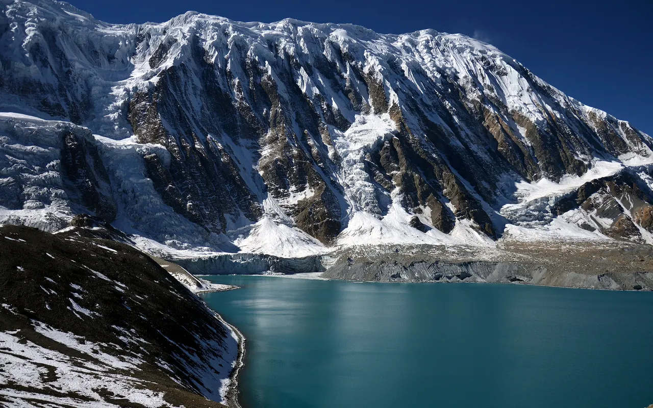
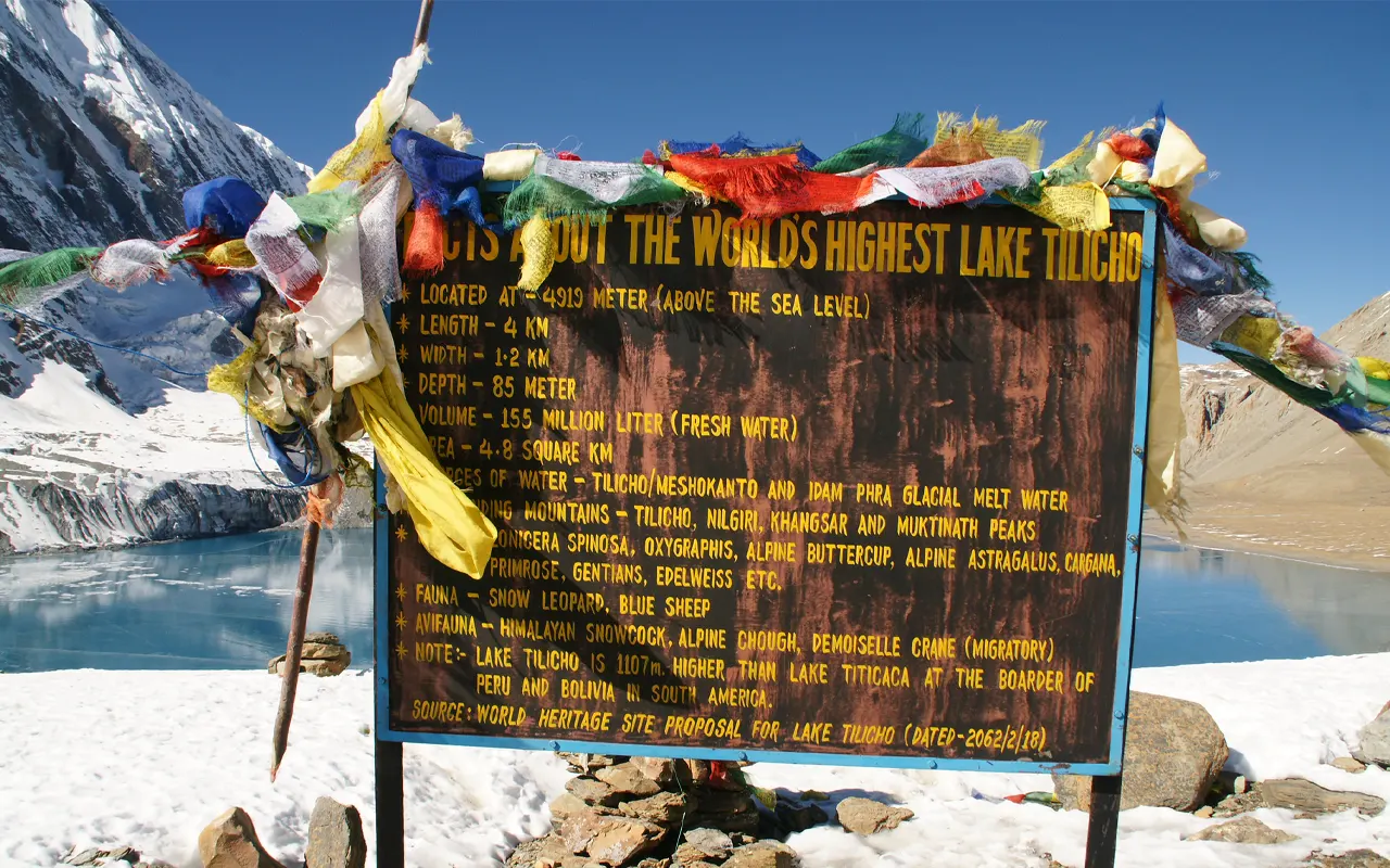
The Tilicho Lake Trek is one of the most exciting and beautiful trekking adventures in Nepal. It brings you to the core of the Annapurna region and takes you to Tilicho Lake (4,920 m / 16,142 ft), which is one of the highest lakes in the world. The trip is a combination of nature, mountain culture, and adventure at high altitude. The landscape is green with hills and rivers, and dry mountainous landscape to snowy mountains, and changes nearly every day.
The Tilicho Lake Trek normally starts from Dharapani at 1,860 m / 6,102 ft. During the journey, the path cuts across the ancient villages such as Chame, Pisang, and Manang, the altitudes of which stand at 3,540 m / 11,614 ft., having beautiful monasteries, prayer flags, and houses made of stones, which are evident remnants of Tibetan culture. The walk enables you to see the life of the natives and, at the same time, enjoy beautiful glimpses of the Annapurna, the Chulu, and other Himalayan mountains.
Slow but steady change in the landscape is one of the key attractions of the Tilicho Lake Trek. The low regions are covered by forest, falls, and terraces. Above 3,000 m / 9,843 ft, the vegetation gets thinner, and the environment turns to wide and open valleys with rocky cliffs. The path to the Tilicho Base Camp (4,150 m / 13,615 ft) may be difficult, particularly in landslides-affected areas. The reward, though, is the arrival at the calm blue waters at Tilicho Lake (4,920 m / 16,142 ft) in the midst of snow-covered mountains.
The Tilicho Lake Trek is described as moderate to difficult due to the height and the length of the walking hours. Altitude sickness should be prevented by proper acclimatization. The short distances traveled by trekkers range between 5 and 7 hours a day within a well-thought-out itinerary, which gives the body the time to adapt to the increased elevation. This is achieved through good physical preparation and having a positive mindset, which makes the journey easier and more fun.
The Tilicho Lake Trek is the destination that people can take when they want to have adventure, culture, and a view of amazing mountains in one trip. Such a trek with good guidance, planning, and aid of an expert organizing agency like the Himalayan Pathways is a safe, memorable, and life-changing experience of the Himalayas.
Highlights of Tilicho Lake Trek – 11 Days
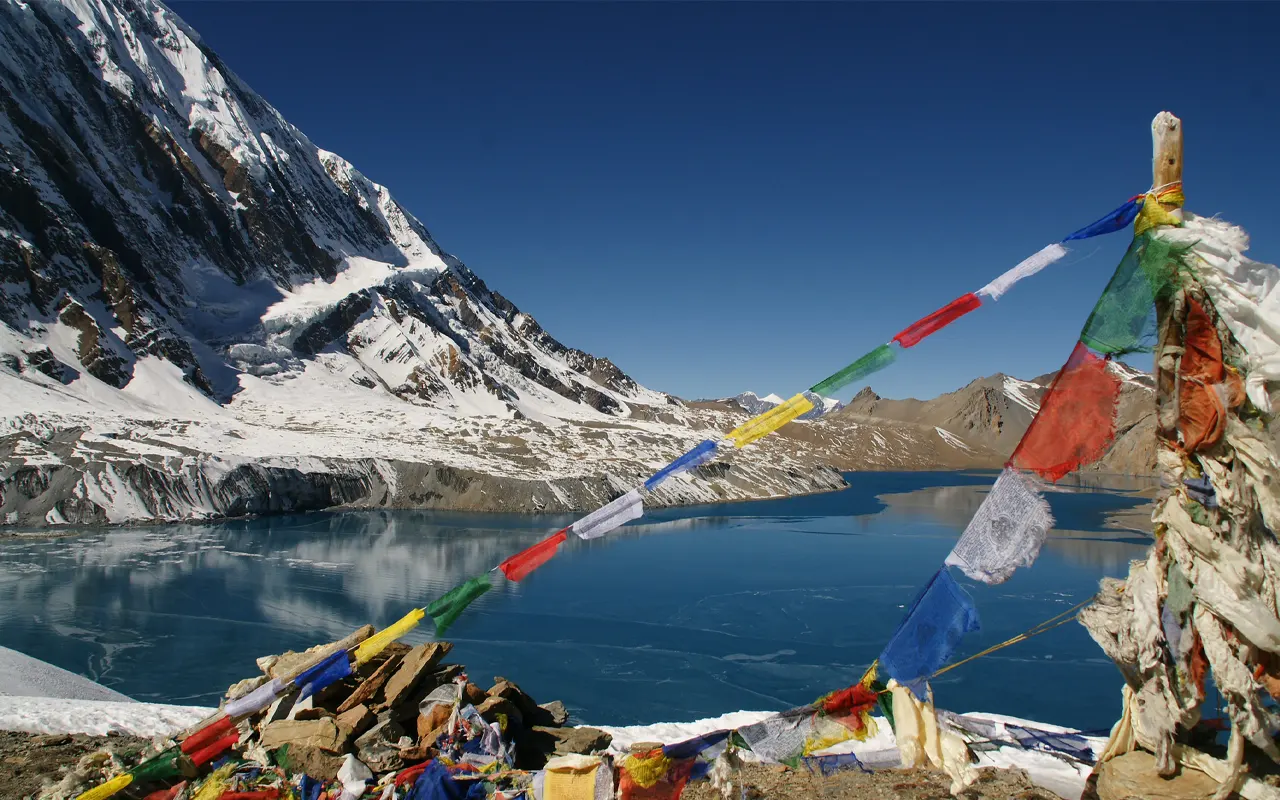
- Visit the beautiful Tilicho Lake (4,920 m / 16,142 ft), which is among the highest lakes on earth.
- Take the spectacular sights of Annapurna, Chulu, and other ice-topped Himalayan Mountains.
- Explore the Tibetan-inspired culture in such villages as Manang (3,540 m / 11,614 ft)
- Explore various terrains, including both green forests and dry alpine valleys greater than 3,000 m / 9,843 ft.
- Hike on scenic cliffs and exciting routes around the Tilicho Base Camp at 4,150 m / 13, 615 ft.
- Visit ancient monasteries with colorful prayer flags and mani walls.
- Enjoy traditional Nepali food such as Dal Bhat in warm mountain tea houses.
- Watch beautiful sunrises and sunsets in the range of the Himalayas.
- See wild animals, including blue sheep and birds of the Himalaya, on the trail.
Tilicho Lake Trek – 11 Days Itinerary
On the first morning of the Tilicho Lake Trek, we depart Kathmandu by local bus to Besisahar (760 m / 2,493 ft). It is a 5- to 6-hour drive along winding roads by the river and through green hills. We switch to a shared jeep after lunch at Besisahar, and have another 3-hour scenic drive to Dharapani (1,860 m / 6,102 ft). The highway crosses over small villages such as Jagat, Chamche, and Tal.
On our road, we have beautiful waterfalls, suspension bridges, and the Marsyangdi Hydropower project. The landscape is laden with terraced fields and green hills. The ride may be rough, yet it will provide a spectacular landscape of nature and local life. It takes approximately 9 hours of travel to reach Dharapani, where we stay the night in a tea house.
Activity & Duration
7 hrs driveHighest Altitude
1,860m / 6,102ft (Dharapani)Meals
Breakfast, Lunch & DinnerAccommodation
TeahouseWe start our walking journey today from Dharapani (1,860 m / 6,102 ft) to Chame (2,670 m / 8,760 ft). The walk takes about 6 hours. Though this has a road, we hike and are in nature. Approximately one-fourth of the trail is along the road. We pass villages, including Chuari Kharka, Timang, and Koto, and walk in forests and across suspension bridges. On the path, we have the sight of Manaslu and other snow-clad mountains.
The trail has both flat and uphill parts. Monasteries and prayer flags are also there, showcasing local culture. Chame is the district head office of Manang district and has most facilities such as shops, bakeries, and internet. When we arrive at Chame, we spend the night in a tea house and have a warm meal.
Activity & Duration
Trekking, 6 hrs hikingHighest Altitude
2,670m / 8,760ft (Chame)Meals
Breakfast, Lunch and DinnerAccommodation
TeahouseWe leave Chame (2,670 m / 8,760 ft) and walk back to Upper Pisang (3,300 m / 10,827 ft). The walk takes about 6 hours. The path crosses Bhratang and Dhikur Pokhari, an apple-growing village. It is mostly uphill with a few flat areas. The trail passes pine woodland and suspension bridges. The local people follow Tibetan culture, and we can observe monasteries and coloured prayer flags on the trail.
We have to be cautious as we can see avalanches on the other mountains. When it is clear, we have beautiful scenery of the Annapurna range. Once at Pisang, it is possible to walk a distance of 100 m (328 ft) to Upper Pisang or a distance of 100 m (328 ft) to Lower Pisang. We spend the night in a tea house.
Activity & Duration
Trekking, 6 hrs hikingHighest Altitude
3,300m / 10,827ft (Upper Pisang)Meals
Breakfast, Lunch and DinnerAccommodation
TeahouseNow we walk out from Upper Pisang (3,300 m / 10,827 ft) and head towards Manang (3,540 m / 11,614 ft). The walk takes about 6 hours. The initial climb is to Ghyaru, and this takes about 2 hours, including some steep uphill parts. There we have the close-up of the Annapurna range. Then we make a walk to Ngawal, where we pass through monasteries and prayer flags.
The village is well-advanced in Tibetan culture. The path goes on through little bushy regions and great mountainous sceneries. We then cross Humde Airport and Bhraka village and arrive at Manang. Manang is a big village that has several facilities like Wi-Fi, bakeries, and stores. We rest and spend the night at the tea house.
Activity & Duration
Trekking, 6 hrs hikingHighest Altitude
3,540m / 11,614ft (Manang)Meals
Breakfast, Lunch and DinnerAccommodation
TeahouseIt is a day of acclimatization in Manang (3,540 m / 11,614 ft) during the Tilicho Lake Trek. We walk to a higher elevation and come back lower elevation to assist our bodies to adapt to the thin air. In the morning, we walk for about 1 hour to Gangapurna Lake, located at an altitude of approximately 3,800 m, 12,467 ft. We have clear views of the Chulu range and the Annapurna range, and all these are seen from the lake.
The snowy mountains and the clear water provide a beautiful sight. We leave Manang after some time, crossing a suspension bridge. The length of the hike is approximately 3 hours. The remainder of the day will be left at liberty to traverse the village, bakeries, or to rest. Overnight stay at a tea house.
Activity & Duration
Trekking, 3 hrs hikingHighest Altitude
3,800m / 12,467ft (Gangapurna Lake)Meals
Breakfast, Lunch and DinnerAccommodation
TeahouseWe are going to leave Manang (3,540 m / 11,614 ft) and trek to Khangsar (3,734 m / 12,251 ft). There are two routes from Manang; we use the trail that leads to Tilicho Lake. The other people who are not going to Tilicho Lake will go to Yak Kharka or Ledar. The path is mostly flat, with some uphill and downhill.
We walk through a dry landscape and see a wide view of the mountains. The landscape is briefer, and the air is becoming thinner as we rise in altitude. We walk to the small town of Khangsar, 5 hours later. It is a small and quiet location with traditional houses and beautiful scenery. We stop and spend the night in a tea house.
Activity & Duration
Trekking, 5 hrs hikingHighest Altitude
3,734m / 12,251ft (Khangsar)Meals
Breakfast, Lunch and DinnerAccommodation
TeahouseToday, we are going from Khangsar (3,734 m / 12,251 ft) to Tilicho Base Camp (4,150 m / 13,615 ft). The trek takes about 4 hours. We go across Siri Kharka, where we can take a rest and get to see the mountains. The Khangsar to Siri Kharka Road has both downhill and uphill trails.
The trail is difficult between Siri Kharka and Tilicho Base Camp. We are passing through a landslide-prone terrain and, therefore, we exercise utmost caution and adhere to the instructions of our guide.
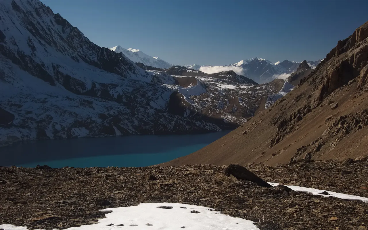
On our way, we observe the Annapurna and Chulu ranges. It is a dry, rocky terrain. Due to the elevation, the amount of oxygen is reduced, and walking might be more difficult. We reach Base Camp and rest, followed by preparing for the next day.
Activity & Duration
Trekking, 4 hrs hikingHighest Altitude
4,150m / 13,615ft (Tilicho Base Camp)Meals
Breakfast, Lunch and DinnerAccommodation
TeahouseWe begin our hike early in the morning from Tilicho Base Camp (4,150 m / 13,615 ft) to Tilicho Lake (4,920 m / 16,142 ft). The lake is approximately 3 hours away. The track is rugged and difficult. We have beautiful mountain views as we continue climbing. We can also occasionally see blue sheep and mountain birds.
The Tilicho Lake is among the highest lakes in the world. The water with snowy mountains all around is blue and forever memorable. Having spent a few hours at the lake, we came back to Base Camp very attentively at lunchtime.
We keep on walking down the landslide zone to Siri Kharka (4,060 m / 13,320 ft). Today, the amount of time walking is approximately 7 hours. We spent the night in a tea house.
Activity & Duration
Trekking, 7 hrs hikingHighest Altitude
4,920m / 16,142ft (Tilicho Lake)Meals
Breakfast, Lunch and DinnerAccommodation
TeahouseToday we are going back from Siri Kharka to Manang (3,540 m / 11,614 ft). The walk takes about 3 hours. We view the same path as we had before. The majority of the path is downhill; thus, the walk is made easier.
We again go through Khangsar village and have a sight of the mountains. It is more pleasant walking downhill as we descend to a lower level.
Once we arrive at Manang, we can skip the stress and have some time to spend on the amenities of the village. This will be an opportune moment to relax after the long climb to the Tilicho Lake. We spend the night in a tea house at Manang.
Activity & Duration
Trekking, 3 hrs hikingHighest Altitude
4,060m / 13,320ft (Siri Kharka)Meals
Breakfast, Lunch and DinnerAccommodation
TeahouseWe leave Manang (3,540 m / 11,614 ft) after breakfast in a jeep heading towards Besisahar (760 m / 2,493 ft). The drive takes about 6 hours. The road is using Marsyangdi River and villages and waterfalls. The trip may be bumpy and dirty, yet the landscapes are gorgeous.
The temperature of the air decreases, and it becomes thicker as we go down to a lower altitude. We go through areas that we had witnessed at the start of the journey.
On arriving at Besisahar, we take a room in a tea house and sleep. When we are back at a lower level, we feel different after spending many days in the mountains. Overnight stay at a tea house.
Activity & Duration
Driving, 6 hrs driveHighest Altitude
3,540m / 11,614ft (Manang)Meals
Breakfast, Lunch and DinnerAccommodation
TeahouseIt is our last day in the 11-day Tilicho Lake Trek. We use the local bus to reach Kathmandu (1,400 m / 4,593 ft) after breakfast from Besisahar (760 m / 2,493 ft). It is a 6-hour drive on the Prithvi Highway.
We pass through rivers and green hills and small towns. As we ride, we are able to recall the beautiful mountains, lakes, and villages we saw.
On reaching Kathmandu, we check into the hotel. Towards the end of the afternoon, a meeting will be held to exchange feedback and experiences of the trek. It is also a good opportunity to appreciate the team and congratulate the successful ride. Overnight stay at the hotel.
Activity & Duration
6 hrs driveHighest Altitude
1,400m / 4,593ft (Kathmandu)Meals
Breakfast, Lunch and DinnerAccommodation
HotelPrice Includes and Excludes
What is included?
- Airport transfer in Kathmandu by a private vehicle.
- On-road transportation according to the schedule (Kathmandu to Besisahar via Dharapani and back to Kathmandu by bus service and shared jeep).
- Overnight in tea houses or lodges throughout the Tilicho Lake Trek on twin sharing.
- Breakfast, Lunch, and Dinner during the trek.
- Professional English-speaking licensed trekking guide, including their salary, meals, accommodation, insurance, and permits.
- Support staff if required, based on the number of the group, including their salary, accommodation, meals, insurance, and transport.
- TIMS card (Trekkers Information Management System) and Annapurna Conservation Area Permit (ACAP).
- A simple first aid kit, which is carried by the guide.
- Sleeping bag and down jacket (to be returned after trek).
- All the government taxes and official service fees.
What is not included?
- Nepal Tourist Visa and international airfare in and out of Nepal.
- Travel insurance (compulsory; should include high-altitude trekking up to 5,000 m / 16,404 ft and emergency helicopter evacuation).
- Hotel stay and dinner in Kathmandu before and after the trek
- Individual costs in the trek (snacks, bottled water, drinks, hot shower, Wi-Fi, charging, laundry, phone calls, etc.).
- Personal trekking equipment (except sleeping bag and down jacket).
- Porter service (on request at extra charge).
- Vehicle upgrade over public transportation (available at an extra charge).
- Other expenses because of early reimbursement, delay, or alteration of the itinerary that are out of the company’s control.
- Guide, porter, and driver tips.
Trip Information
Difficulty Level
Tilicho Lake Trek is regarded as a difficult trek with a high altitude. It begins at Dharapani (1,860 m / 6,102 ft) and progressively ascends to Tilicho Lake (4,920 m / 16,142 ft). This trek is challenging due to the long walking hours, the daily altitude gain, and the thin air. Trekkers tend to walk 5-7 hours in one day.
The primary challenge is adapting to an elevation of more than 3,000 m / 9,843 ft, to an area where there is less oxygen available. To prevent sickness at a given time, proper acclimatization is crucial. The route also has the rocky tracks and landslides-prone zones around the Tilicho Base Camp.
Nevertheless, under careful planning and the assistance of the Himalayan Pathways, the Tilicho Lake Trek can be completed by the majority of healthy trekkers. The ability of the mind, patience, and a slow pace of walking are important aspects regarding coping with the level of difficulty in this adventure.
Weather and Best Season
Another factor that is significant in the planning of the Tilicho Lake Trek is the weather. Spring (March to May) and autumn (September to November) are the most appropriate seasons. Throughout these months, the skies are mostly clear, and the mountain sceneries are sharp and beautiful.
At low altitudes, such as Dharapani (1,860 m / 6,102 ft), temperatures are moderate, whereas at higher altitudes, such as around Tilicho Lake (4,920 m / 16,142 ft), it is considerably colder. During springtime, rhododendron come into bloom and make the trail colorful. The weather is stable in autumn after the monsoon season.
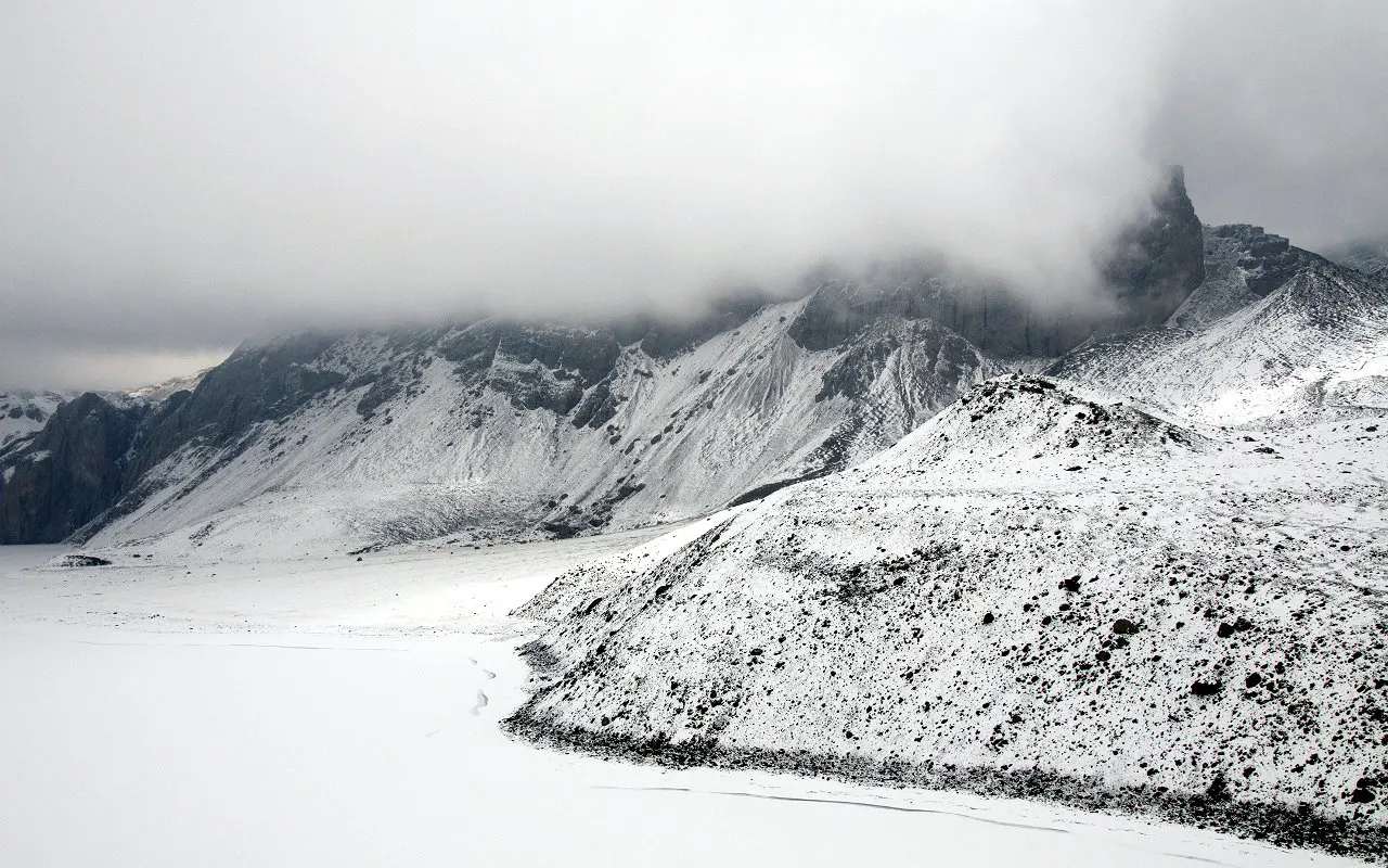
During winter, there is a lot of snow on the higher altitudes, which may block the route. June to early September is the rainy season, and there are slippery roads.
Himalayan Pathways pays a lot of attention to the Tilicho Lake Trek itinerary planning in terms of the seasonal weather to offer more favorable and safe conditions for the trek.
Foods and Drinks
You will be eating and sleeping in tea houses during the Tilicho Lake Trek. A large menu including non-vegetarian and vegetarian meals exists in most of the lodges of the Annapurna region. Dal Bhat, comprising rice, lentil soup, vegetables, and pickles, is a favorite and rich dish of energy. Fried rice, pasta, noodles, momos, pancakes, chapati, porridge, and eggs are the other choices.
Non-vegetarian dishes may include chicken or pork, but it is always best to check with your guide to make sure the food is hygienic.
Hydration is also very crucial, where one should drink enough water, particularly over 3,000 m / 9,843 ft. Purification tablets or filters would be safer to use to purify tap water rather than purchasing plastic bottles. You can also drink boiled water. Consume balanced food to ensure that they have the strength to arrive at Tilicho Lake (4,920 m / 16,142 ft.)
Altitude Sickness and Suggestions
The issue that can be brought up when discussing the Tilicho Lake Trek is altitude sickness due to the trail passing above 3,000 m / 9,843 ft and reaching an altitude of 4,920 m / 16,142 ft at Tilicho Lake.
Altitude sickness occurs as a result of low oxygen at high altitudes. The typical effects are a headache, nausea, dizziness, dyspnea, and fatigue. To avoid this, trekkers are advised to climb at a slow pace and observe the appropriate rules of acclimatization. Researchers indicate that one should not gain more than 400-500 m (1,312-1,640 ft) at some altitudes in a day.
Consumption of adequate water and avoiding alcohol is also helpful. In case the symptoms are severe, one should go down to a lower altitude. To minimize risks, Himalayan Pathways packages the itinerary of the Tilicho Lake Trek with acclimatization days. It is essential to listen to your body and let the guide know in advance in case of danger.
Preparation and Fitness
The Tilicho Lake Trek requires good preparation in order to accomplish it. As the trek starts at 1,860 m / 6,102 ft and goes to 4,920 m / 16,142 ft, not only will you require physical strength, but mental strength as well.
It is good to exercise regularly in the form of walking, hiking, jogging, or cycling for a few weeks before the trip. Concentrate on stamina and leg strength. One should practice walking uphill with a backpack to get ready to walk 5-7 hours daily.
It is also important to pack the right equipment that includes hiking boots, warm jackets, gloves, hats, and a sleeping bag. One should carry a first aid kit and a water purification system.
Himalayan Pathways recommends that trekkers train for a minimum of 1 to 2 months before starting the Tilicho Lake Trek to perform better and with comfort.
Visa and Permits
To participate in the Tilicho Lake Trek, you will also need a valid Nepal visa and trek permits. The majority of the tourists will be able to acquire a tourist visa at Tribhuvan International Airport or overland border.
To do the trek, you require two permits, which include a TIMS card (Trekkers’ Information Management System) and an ACAP permit (Annapurna Conservation Area Permit). The permits aid in controlling the trekking activities and environmental conservation in the Annapurna region. It is also advisable to carry copies of the passport and passport photos.
Himalayan Pathways will organize all the relevant permits, so you can enjoy an easy legal adventure to Tilicho Lake.
Health and Safety
When going to Tilicho Lake Trek, health and safety are the most important concerns. As the trek is taken to high altitude locations that are above 3,000 m / 9,843 ft and as high as 4,920 m / 16,142 ft, good acclimatization is required.
Trekkers are advised to keep themselves hydrated, consume healthy food, and walk at a comfortable pace. It is important to have personal medicines, travel insurance, and a basic first aid kit. There are landslides along the trails around Tilicho Base Camp, and one should walk cautiously. The weather in the mountains may vary rapidly, and therefore warm clothes and rain gear are necessary.
Some of the villages have communication facilities such as WiFi, and Ncell has better network coverage. The Himalayan Pathways provides trained guides who would be observing your well-being and provide fast transitions in case of emergencies.
Transportation
The Tilicho Lake Trek typically begins with a 6-hour trip by road from Kathmandu to Besisahar. After lunch, a 3-hour ride on a jeep transports you to Dharapani at 1,860 m / 6,102 ft, and the trek begins.
Another alternative is Kathmandu to Pokhara (approximately 25 minutes flight) and Jomsom (approximately 20 minutes flight), which depends on the itinerary. The trekkers usually end the trek in Jomsom, where you can have a flight back to Pokhara and Kathmandu. Road transport is also available to Pokhara by a local or private jeep.
Traveling by road may be tedious and rough, particularly in the mountains. Himalayan Pathways provides safe and comfortable transportation so that the trekkers can enjoy the experience of the Tilicho Lake Trek, no matter which route you choose.
Travel Insurance
The Tilicho Lake Trek is very sensitive to travel insurance. There are chances of elevation sickness or unpredictable harm since this trek goes up to great heights, such as 4,920 m / 16,142 ft at Tilicho Lake.
High-altitude trekking above 5,000 m (16,404 ft) and emergency helicopter evacuation should be covered by your insurance. Helicopter rescue can be the quickest and safest in the far mountainous regions in case of severe health issues. Ensure that medical treatment, trip cancellation, and lost luggage are also covered in your policy.
Submit a copy of your insurance information to Himalayan Pathways to maintain a record of the same before the start of the Tilicho Lake Trek.
Rescue and medical services are highly costly in Nepal without adequate insurance. Good travel insurance brings peace of mind and enables one to go on with the adventure in the Annapurna region, enjoying it to the fullest.
Alternative Routes
The Tilicho Lake Trek has a number of other trails. Some trekkers will include Tilicho Lake at 4,920 m / 16,142 ft with the entire Annapurna Circuit, including Thorong La Pass at 5,416 m / 17,769 ft.
Some do not even go to Tilicho Lake, but instead just head directly from Manang at 3,540 m / 11,614 ft towards Yak Kharka and Thorong Phedi.
As an alternative, one can end the trek at Jomsom and tour the Mustang region. The paths provide a variety of landscapes, as there are green valleys as well as deserts.
Himalayan Pathways is capable of modifying the itinerary according to your interests, time, and fitness. We can also help to choose another path to acclimate better. Tilicho Lake Trek is not fixed, and the trekkers are able to tailor their trek and still have the best Himalayan scenery.
Your Extra Expenses
In the Tilicho Lake Trek, there are certain expenses that will not be part of the package. The additional costs can be a hot shower, charging batteries, WiFi, snacks, bakery items, and bottled drinks. The higher you go, the higher the prices, mostly above 3,000 m / 9,843 ft, since goods are carried by mule or porter.
There should also be personal expenses of laundry, souvenirs, guide and porter tips, and so on. Personal trekking equipment, visa charges, and travel insurance are not included in the Tilicho Lake Trek Package.
You have enough cash in Nepalese rupees because there are no ATMs in the villages after Kathmandu.
Language and Communication
Nepali is the official language of Nepal, and English is commonly used in the trekking regions. In the Tilicho Lake Trek, the majority of the guides, lodge owners, and staff can speak basic English. Communication is usually simple in villages.
The Tibetan dialects may be spoken by local people. It is not hard to learn some simple Nepali words to say things such as Namaste (hello) and Dhanyabad (thank you), which the locals are happy to hear.
Himalayan Pathways offers quality trekking guides who are well-trained in English to assist the trekkers during the journey.
It should be communicated well, and whenever health conditions are discussed, such as at higher altitudes, such as the Tilicho Lake at 4,920 m / 16,142 ft.
Communicate in a friendly manner when interacting with the local communities, and this makes the Tilicho Lake Trek easier and even more culturally enriching.
Charging Facilities, Internet, and Mobile Network
There are charging facilities in most of the tea houses when you are on the Tilicho Lake Trek, and you might have to pay an additional fee. Above 3,000 m / 9,843 ft, there might be a limitation in electricity, and it will probably be solar-powered. It is recommended to carry a power bank or portable solar charger.
Many of the villages have WiFi, like Manang at 3,540 m / 11,614 ft, though the connection can be slow, and you will have to pay a certain fee for it.
In the case of mobile networks, Ncell has a superior coverage in the Annapurna area. Signal strength, however, drops at and around Tilicho Lake at 4,920 m / 16,142 ft.
Trekkers should share this information with their family before the Tilicho Lake Trek, as the mobile signal can be weak in this area.
Don’ts on This Trip
One needs to remember that there are things not to be done during the Tilicho Lake Trek. Do not ascend too rapidly without developing acclimatization above 3,000 m / 9,843 ft. Do not drink alcohol at high altitude, as this puts one at risk of becoming sick. The tap water should not be consumed without being purified.
Littering is highly discouraged, since the Annapurna region is a conservation site. Do not interfere with wildlife, harm local culture, or enter a religious place without permission. Just below Tilicho Lake at 4,920 m / 16,142 ft, follow your guide’s instructions carefully, especially in areas where landslides may occur.
Himalayan Pathways promotes the idea of responsible trekking in order to conserve the environment and maintain safety. The Tilicho Lake Trek is a safe and enjoyable experience for all because of respect for the local traditions and the mountain environment.
Trip Extension
Having finished the Tilicho Lake Trek, a lot of trekkers decide to prolong their trip. Most of the time, the choices of places to visit are going to Pokhara to relax by the Phewa Lake or visit the Chitwan National Park, where one can also see wildlife. Some people also go to the Lumbini birthplace of Lord Buddha.
When you go through Thorong La Pass at 5,416 m / 17,769 ft, you may proceed to Muktinath, which is a holy pilgrimage place.
Himalayan Pathways will be able to plan tailor-made trip extensions according to your interests and schedule. By adding on to the number of days, you can also experience more of the Nepalese culture and natural beauty once you have reached Tilicho Lake. An extension of the trip will be the best way to make your stay at the Tilicho Lake Trek even more memorable.
Tips for First-Time Visitors
If this is your first time at the Tilicho Lake Trek, be ready and take your time. Begin physical training no less than one month before arrival. Pack light, but make sure to bring warm layers for cold weather at 4,920 m / 16,142 ft.
Walk slowly and drink plenty of water, especially above 3,000 m / 9,843 ft. Do as your guide says and never neglect altitude sickness symptoms. Come with enough money in order to cater to personal needs, because they don’t take payment by cards in isolated locations.
Be considerate and meet the locals with courtesy. Himalayan Pathways suggests that you come a day before Kathmandu to settle down and look at your equipment. The Tilicho Lake Trek is a safe and rewarding experience for first-time trekkers with proper preparation and the right attitude.
Frequently Asked Questions
Is Tilicho Lake a sacred Place?
Yes, Tilicho Lake at 4,920 m / 16,142 ft is a religious site to both the Hindu and Buddhist people.
What is the terrain like on the trail?
The trail consists of forest trails, rocks, and parts subject to landslides, as well as high-altitude terrain.
Can I have porters who can help carry luggage?
Yes, you can have porters who can carry your main duffel bag (usually 1 porter per 2 trekkers).
Is a sleeping bag necessary?
Yes, it is advisable to use a warm sleeping bag that is designed for cold weather, particularly above 3,500 m / 11,483 ft.
Do the routes have medical facilities?
Health services are basic in other villages, such as Manang (3,540 m / 11,614 ft), and the more advanced services are minimal.
Is it possible to accommodate dietary restrictions?
Vegetarian and easy vegan ones are prevalent, but special diets must be pre-informed.
Is the trail crowded?
The trail is not very crowded, even in peak season, and is quieter compared to other popular trekking routes.
What wildlife might be seen?
Trekkers can see blue sheep, birds of the Himalaya, and, in some cases, mountain goats.
Should the guides and porters be tipped?
Yes, it is normal to tip, and the service is valued.
Does it have a hot shower during the trek?
Yes, a hot shower can be found in most tea houses at an extra cost.
What is the coldest temperature in Tilicho Base Camp?
It can get down to temperatures below the freezing point at 4,150 m / 13,615 ft, particularly at night.
Are there single rooms during the trek?
The single rooms can be offered at lower altitudes, but are scarce at the higher levels.
Does it require prior experience at high altitude for this trek?
Although not a requirement, prior experience of 3,000 m / 9,843 ft or above would be helpful.
What kind of shoes are suggested?
It is strongly suggested to wear hiking boots that are waterproof, have high ankle support, and are durable.
Is it possible to hire trekking equipment in Kathmandu?
Yes, Kathmandu has most of the necessary trekking equipment that can be hired or bought.
Does it have a limit on baggage weight for porters?
Yes, the average weight should not be more than 10-12kg per person.
Does it have bakery items on the route?
Yes, there are bakeries in such villages as Manang that sell fresh bread and pastries.
Can the itinerary be customized?
Yes, the itinerary may be changed as per your fitness and the time available.
What are the cultural experiences that I will have?
You will get a taste of Tibetan-inspired traditions, monasteries, and the real village life.
Does the trail have suspension bridges?
Yes, several suspension bridges are crossed, particularly in the lower parts of the trek.
Is the trail clearly marked?
The majority of the sections are marked, yet it is highly advisable to employ a guide to ensure safety.
At what time do trekkers begin their daily walking?
The trekking starts at 7:00 AM to 8:00 AM most of the time.
Is snow common on the trail?
During colder times, snow may occur around Tilicho Lake at 4,920 m / 16,142 ft.
Can children do the Tilicho Lake Trek?
Fit children who have previously taken part in trekking can complete the trek under proper supervision.
What are the accepted payment methods on the trail?
The first and most trustworthy way of payment is through cash in Nepalese Rupees.
Are there monasteries to be seen?
Yes, there are a few Buddhist monasteries within the villages along the trekking path.
How long does it take to reach Tilicho Base Camp from Manang?
Tilicho Base Camp at 4,150 m / 13,615 ft is usually reached in two days from Manang at 3,540 m / 11,614 ft.
Does it need camping during this trek?
No, it is a tea house trek where one will stay in a lodge during the journey.
How many people will be in this trek on average?
The size of the groups is usually 2-10 trekkers.
What is unique about the Tilicho Lake Trek in comparison with other treks?
The combination of high-altitude adventure, dramatic scenery, cultural villages, and the beautiful lake at 4,920 m (16,142 ft) makes it a very special trip in the Himalayas.
Reviews on Tilicho Lake Trek – 11 Days
- Your safety, our priority
- Best price guarantee
- Experienced & dedicated team
- Easy booking, no hidden charge
- You can customize this trip