Duration
24 Days
![]() Unbeatable Holiday Offers - Save Up to 20% on Your Next Adventure!
Unbeatable Holiday Offers - Save Up to 20% on Your Next Adventure!
Upper Dolpo Circuit Trek
Trip Difficulty
ModerateMax. Altitude
5360 MetresGroup Size
2-20 PeopleBest Season
Mar-May, Sep-NovTransportation
FlightAccommodation
Teahouse, Hotel, TentMeals
Breakfast, Lunch and Dinner- Your safety, our no 1 priority
- Best price guarantee
- Experienced & dedicated team
- Easy booking, no hidden charge
- You can customize this trip

Trip Overview
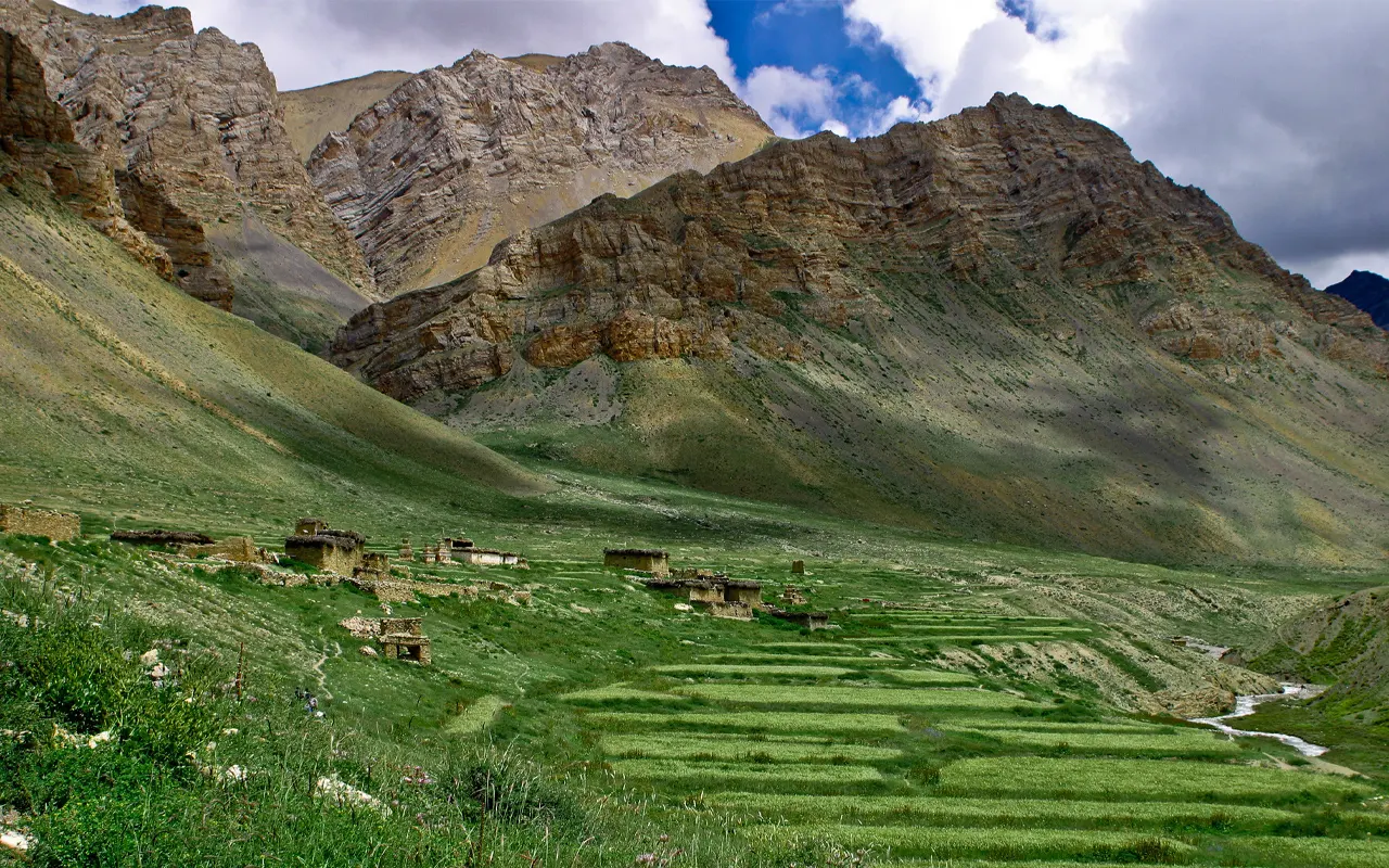
The Upper Dolpo Circuit Trek is a very remote and unique trekking journey in Nepal. The Dolpo region is situated in the far west of the Himalayas, where there are untouched, ancient, and serene mountain villages. This journey leads you into a secret valley in the Himalayas, where the various Tibetan traditional cultures, high mountain ranges, and beautiful lakes combine to create an invaluable experience. Since the area has been secluded over time, it has a very conservative lifestyle.
The Upper Dolpo Circuit Trek journey starts with a short flight from Kathmandu to Nepalgunj and then to Jhupal at approximately 2,475 m / 8,120 ft, the point where the trek begins. The route starts and goes through the picturesque villages, forests, and valleys of rivers, to the breathtaking Phoksundo Lake (3,611 m / 11,847 ft). One of the most well-known places of the Dolpo region is a bright turquoise coloured lake bordered by cliffs and snow-capped mountains, the Shey Phoksundo Lake.
As the Upper Dolpo Circuit Trek goes on, the trekkers walk through isolated valleys and traditional villages where residents practice the Tibetan Buddhist culture. The spiritual traditions of the regions are manifested in ancient monasteries, prayer flags, and stone houses. Several high mountain passes that are covered in the trek are Kang La Pass at 5360 m / 17585 ft and Jeng La Pass at 5, 090 m / 16699 ft, which provide the most picturesque views of the Himalayan landscape.
The next highlight of the Upper Dolpo Circuit Trek is the possibility to see Shey Gompa, located at 4,343 m / 14, 249 ft which is an ancient monastery that is very significant to the communities living in the area. The walk traverses the largest national park in Nepal, the Shey Phoksundo National Park, where sightings of wildlife like blue sheep and snow leopard are found in rare conditions.
The Upper Dolpo Circuit Trek is the most appropriate trek that offers adventure, culture, and wilderness to the trekkers due to its remote location. The trip is an exclusive opportunity to explore one of the most remote areas of the Himalayas. Through a well-planned trekking experience, led by knowledgeable guides from Himalayan Pathways, we can assist you in discovering such an amazing place in Nepal safely.
Highlights of Upper Dolpo Circuit Trek
- Travel to the cultural Dolpo in western Nepal.
- Explore the beautiful Phoksundo Lake that is 3,611 m / 11,847 ft high.
- Cross high Himalayan passes such as Kang La Pass with an elevation of 5,360 m / 17, 585 ft.
- Experience the remote Tibetan Mountain villages.
- Visit the historic Shey Gompa monastery at 4,343 m / 14,249 ft.
- Hike in the Shey Phoksundo National Park.
- Experience the dramatic scenery with deep valleys, rivers, and snow-covered mountains.
Upper Dolpo Circuit Trek Itinerary
Your Upper Dolpo Circuit Trek will start with a beautiful flight from Kathmandu to Nepalgunj, a bustling town in the lowlands of the west of Nepal at the border with India. On reaching Tribhuvan International Airport, you take a domestic flight that flies in a western direction. Green hills, rivers, and scattered villages will offer beautiful scenery during the flight before you enter the warm plains of Terai.
Nepalgunj is not at the same elevation as Kathmandu, and it also does not share a similar climate and cultural ambiance. Upon arrival, you shift to your hotel and get some time to rest and get ready to go through the trek. This is a common stop for many trekkers where they pack their trekking equipment and get to meet the guide and support staff.
During the evening, your trekking guide normally undertakes a briefing to you on the route, weather conditions, and information on safety related to the forthcoming adventure of the Upper Dolpo Circuit Trek.
Activity & Duration
Flight, 1 hr flightHighest Altitude
1,400m / 4,593ft (Kathmandu)Meals
Breakfast, Lunch and DinnerAccommodation
HotelYou start early in the morning with a short mountain flight from Nepalgunj to Jhupal, the entrance to the Dolpo region. Air travel provides spectacular scenery of mountains, valleys, and distant mountains covered with snow. Jhupal is located at 2,475 m / 8,120 ft and is the primary point of beginning for the trekkers in Dolpo.
The trekking adventure starts after landing. The path is a slow one down steep terraced fields and rural villages. You pass through the Thuli Bheri River valley, where there are local houses and barley farms, where people live in accordance with their traditional style.
The trail is generally easy, and you will progressively get used to the rising terrain. You can come across friendly locals and a mule train along the way carrying supplies.
Within hours of walking, you arrive at Dunai, which is the administrative center of Dolpo. This village by the river provides a good initial night at the Upper Dolpo Circuit Trek.
Activity & Duration
Flight and Trek, 3 hrs hikingHighest Altitude
2,475m / 8,120ft (Jhupal)Meals
Breakfast, Lunch and DinnerAccommodation
TeahouseThe trek today extends further into the Dolpo region as the trail follows the Thuli Bheri River. After breakfast in Dunai, the way passes through forests and classic mountain villages.
The path takes one through pine and walnut trees, and the sound of the river is heard on the path. You will see mule transport between villages along this part of the trail.
The initial section of the trek is quite easy, and trekkers can have time to take in the serene environment and get used to the altitude. The path gradually becomes steep towards Ankhe as the day goes on.
Certain portions of the road narrow with a cliffy ledge above the river valley. You arrive at Ankhe (2,896 m / 9,501 ft) in the afternoon. It is a small village in the middle of hills and natural beauty.
Activity & Duration
Trekking, 6–7 hrs hikingHighest Altitude
2,896m / 9,501ft (Ankhe)Meals
Breakfast, Lunch and DinnerAccommodation
TeahouseThis day is more of an adventure because the trek is done through narrow paths cut through the steep rocky hillsides along the riverbank. The path encompasses several highs and lows, and the walk is more difficult than the day before.
Trekkers go through thick forests and rough landscapes as they trace the Suligad River valley. In certain areas, the path cuts through wooden bridges and rocky roads, which one should step on carefully.
The terrain is impressive in spite of its difficulty. This is a scenic natural landscape made up of waterfalls, deep gorges, and unspoiled forests.
The road passes down the Sulighat slowly, at 2,100 m / 6,890 ft. This is the place where the Shey Phoksundo National Park, which is the biggest national park in Nepal, begins. Sulighat offers a serene camping experience along the riverbank where the trekkers stop and have their sleep before they proceed to Phoksundo Lake.
Activity & Duration
Trekking, 6–7 hrs hikingHighest Altitude
2,896m / 9,501ft (Ankhe)Meals
Breakfast, Lunch and DinnerAccommodation
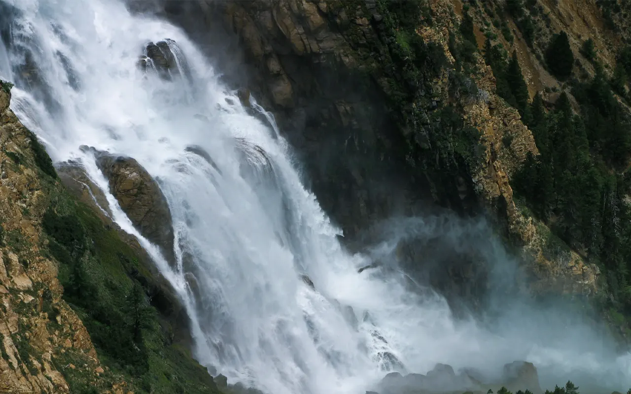
TeahouseIt is one of the most thrilling days in the Upper Dolpo Circuit Trek today when you arrive at the beautiful Phoksundo Lake. The trail ascends slowly through pine and cedar forest, tracing the Suligad River.
The trekkers also cross the highest waterfall in Nepal, which cascades down the valley on high cliffs. The walk is very memorable due to the sound of rushing water and the mountain scenery that surrounds it.
As the path moves further up the mountain, the turquoise hue of the Phoksundo Lake gradually emerges amid the mountains. The lake is located at an elevation of 3,611 m / 11,847 ft and is said to be one of the most beautiful lakes in Nepal.
Close to the lake is Ringmo village, a classic village with Tibetan houses. The serene lake scene provides an ideal atmosphere for staying overnight.
Activity & Duration
Trekking, 5–6 hrs hikingHighest Altitude
3,611m / 11,847ft (Phoksundo Lake)Meals
Breakfast, Lunch and DinnerAccommodation
TeahouseToday will be an acclimatization day. You will spend more time at Phoksundo Lake so that your body will get used to the higher altitude and then proceed further into the Dolpo region.
Phoksundo Lake, located at 3,611 m / 11,847 ft, is known for its bright turquoise waters and dramatic mountains and cliffs.
Following breakfast, you will be able to tour the village of Ringmo, which is a traditional village with Tibetan influence. The village consists of stone houses, prayer flags, mani walls and tiny monasteries.
Several brief hikes along the lake are advisable in order to aid in acclimatization. There are amazing sceneries of the surrounding mountains and forests as one walks along the lakeside.
This day is very relaxing and gives a wonderful opportunity to heal in the natural beauty of Dolpo because of the peaceful environment.
Activity & Duration
Acclimatization, 3 hrs hikingHighest Altitude
3,880m / 12,730ft (Phoksundo Khola Camp)Meals
Breakfast, Lunch and DinnerAccommodation
TeahouseUpon witnessing the beauty of the Phoksundo Lake, the Upper Dolpo Circuit Trek moves on an exciting path that is located above the lake. It is a rugged trail cut through steep precipices, which shows some magnificent glimpses of the deep blue water beneath.
The path slowly leaves the lakeside and climbs the valley of the Phoksundo Khola river. The terrain becomes deeper and more distant as the trek enters mountainous areas.
Trekking along, the visitors encounter high cliffs, waterfalls, and pristine nature. Villages are infrequent as the road cuts off into more remote mountain districts.
At midday, you arrive at Phoksundo Khola Camp at approximately 3,700 m / 12,139 ft. The camp is located in a peaceful natural location on the bank of the river with a spectacular mountainous background.
Activity & Duration
Trekking, 5–6 hrs hikingHighest Altitude
3,700m / 12,139ft (Phoksundo Khola Camp)Meals
Breakfast, Lunch and DinnerAccommodation
TentToday, the trek enters more high-altitude terrains with the trail running on the upper Dolpo valley of Phoksundo Khola. The road leads slowly upward, through the rocky parts and the open country mountain pastures.
As you go, you can spot yaks and sheep grazing on the broad valley. The higher a person goes, the colder the air and the more striking the scenery is.
The road features easy ascents on the river and elevated terrain. The valley is surrounded by snow-clad mountains and bare hills at high places.
Towards late afternoon, you reach Phoksundo Bhanjyang (4120 m / 13517 ft). The mountain views and the rocky hills that surround this high campsite are wide. Staying here helps trekkers prepare for the upcoming high pass and the next part of the Upper Dolpo Circuit Trek.
Activity & Duration
Trekking, 6–7 hrs hikingHighest Altitude
4,120m / 13,517ft (Phoksundo Bhanjyang)Meals
Breakfast, Lunch and DinnerAccommodation
TeahouseIt is considered to be one of the most rewarding days of the Upper Dolpo Circuit Trek today. The route ascends consistently up to Kang La Pass, 5,360 m / 17,585 ft, which is one of the highest points in the trip. It is difficult due to the altitude, yet the scenery is spectacular and makes it worth climbing.
On the way up to the mountains, the scenery expands and opens up to Himalayan expanses of snow-white peaks and distant valleys.
There are multiple colorful prayer flags that move in the wind, creating a certain calm and spiritual atmosphere. Trekking in this direction, the trekkers can have the stunning panoramic outlook of the Dolpo region. The trail leads downwards to the sacred Shey Valley after a short time at the pass. The landscape transforms to expansive valleys with monuments and stonework of ancient Buddhism.
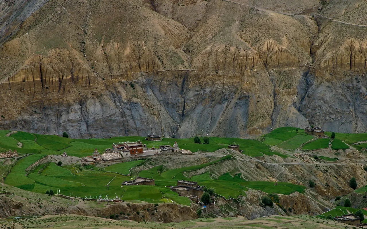
Lastly, there is the Shey Gompa at 4,343 m / 14249 ft, which is a historic monastery and one of the spiritual locations in the Upper Dolpo Circuit Trek.
Activity & Duration
Trekking, 7–8 hrs hikingHighest Altitude
5,360m / 17,585ft (Kang La Pass)Meals
Breakfast, Lunch and DinnerAccommodation
TeahouseThe trek involves another day of acclimatization today, as your body gets used to the altitudes of Shey Gompa. This holy monastery is more than 800 years old, and it is a significant spiritual hub of the Dolpo people. The natural environment is tranquil, thus making it an ideal resting and touring spot.
You may go to the monastery after breakfast and get to witness the traditional practice of Buddhism. The area is adorned with prayer flags, mani stones, and chortens, indicating the high spiritual culture of the area. The valley is also referred to as the Crystal Mountain Valley, which is a religious site that is visited by pilgrims.
Trails along the valley are useful in acclimatization, and they have spectacular views of the surrounding mountains and the open landscapes. These light walks assist the body to acclimate itself to the elevation and proceed with the hike.
Activity & Duration
Acclimatization, 3 hrs hikingHighest Altitude
4,800m / 15,748ft (Namduna Gaon)Meals
Breakfast, Lunch and DinnerAccommodation
TeahouseThe Upper Dolpo Circuit Trek leaves the holy Shey Valley and goes towards Namduna Gaon. The path ascends slowly up to Saldang La Pass (4,785 m / 15,698 ft). This part goes through expansive mountainous terrain with scenic mountainous scenery and open plains.
The trail crosses the pass and leads down into a large valley where small settlements and pastures are observed. The landscape echoes the common trans-Himalayan setup of Dolpo, which is characterized by arid hills and mountain ranges in the distance.
Trekkers move in isolated villages where the culture of Tibet is still very strong. The trail is adorned with prayer flags, chortens, and mani walls that signify the spiritual history of the area.
Afternoon, you arrive at Namduna Gaon at 4,800 m / 15,748 ft. The small village, which has a monastery close by, is a perfect location to relax during the trek.
Activity & Duration
Trekking, 7 hrs hikingHighest Altitude
4,800m / 15,748ft (Namduna Gaon)Meals
Breakfast, Lunch and DinnerAccommodation
TeahouseThe journey is shorter and easier than the previous trekking days. The path is an easy way up and down broad valleys and dry hills, which are the characteristics of Dolpo.
Looking as you walk, you will find the old stone houses, small farms, and grazing grounds where you will find the yaks and sheep grazing. The locals of this place depend on animal herding and farming to earn their living. The landscape is open, offering clear views of the mountains and high plateaus around it.
In a couple of hours, you reach Saldang at 3,770 m / 12,369 ft. At Saldang, one of the largest villages of the Upper Dolpo, you will find the main trading post. In the village, there are several monasteries and tightly fitting traditional houses.
Activity & Duration
Trekking, 4–5 hrs hikingHighest Altitude
4,800m / 15,748ft (Namduna Gaon)Meals
Breakfast, Lunch and DinnerAccommodation
TeahouseThe trek is towards Yangze Gompa today, which is among the oldest monasteries in Dolpo. The route is fairly smooth over the open valleys and in small settlements where the Tibetan culture is firmly held.
Trekking along the route, you see chortens, prayer flags, and mani walls as evidence of the rich Buddhist culture of the region. It is a wide landscape that is dry with mountains in the distance that creates a dramatic background.
One may frequently see local people engaged in activities like working in the fields or leading the yak caravans across the valley. This part of the trek is quite pleasant due to the calm nature.
In a few hours of walking, you come to Yangze Gompa, at 4 960 m / 16 273 ft. The local people have a place of worship here, and it is an excellent site to stay with the serene and beautiful environment of this important monastery.
Activity & Duration
Trekking, 5–6 hrs hikingHighest Altitude
4,960m / 16,273ft (Yangze Gompa)Meals
Breakfast, Lunch and DinnerAccommodation
TeahouseAfter parting ways from the Yangze Gompa, the trek passes across remote mountain valleys. The road gradually goes down through barren hills and along the river valley.
Trekkers go through tiny communities and pastures where the yaks and sheep are frequently seen. The walk is very pleasant owing to the peaceful scenery and expansive valleys.
The mani walls and prayer flags are traditionally found on the road, which demonstrate the high cultural traditions of the Dolpo region. The trail is greener towards the river as one goes further.
Several hours of walking take you to the camp at Sibu, which is standing at 4,560 m / 14,960 ft. The campsite is on the banks of the river and can be used to have a peaceful rest before going through another high mountain pass.
Activity & Duration
Trekking, 6 hrs hikingHighest Altitude
4,960m / 16,273ft (Yangze Gompa)Meals
Breakfast, Lunch and DinnerAccommodation
TeahouseThe trek continues today to the base of Jeng La Pass. The trail takes the Nam Khong Khola valley and ascends slowly through a far-flung mountain terrain.
The trail passes through grassy fields where yaks often graze peacefully. The nature surrounding the area is made up of broad valleys, rocky hills, and snow-covered mountains in the distance.
There are not many settlements in this part of the trek, which demonstrates the remoteness of the Dolpo region. The gradual ascent will ensure that trekkers walk at their own pace and the surrounding is serene.
In the afternoon, you arrive at Jeng La Phedi (4,900 m / 16,076 ft). It is a camp that is located at the foot of Jeng La Pass and is used to acclimatize the trekkers for the difficult pass they are going to cross the next day.
Activity & Duration
Trekking, 6 hrs hikingHighest Altitude
4,900m / 16,076ft (Jeng La Phedi)Meals
Breakfast, Lunch and DinnerAccommodation
TentIt is one of the most interesting days of the Upper Dolpo Circuit Trek in which you cross Jeng La Pass at 5,090 m / 16,699 ft. It starts early and ascends slowly through rocky alpine landscapes.
On reaching the summit of the pass, you see before you in the distance the snow-covered mountain peaks and deep valleys of the Himalayas. Colored prayer flags at the top provide a spiritual view.
It is then followed by the trail to the Tarap Valley after the astonishing panoramic view. The terrain becomes expansive grasslands and open valleys, where the yaks are grazing.
Soon enough, you arrive at Tokyu Gaon 4,240 m / 13,910 ft. The village is among the permanent settlements that are at the highest altitude in Dolpo and provides an insight into the traditional Tibetan culture.
Activity & Duration
Trekking, 7–8 hrs hikingHighest Altitude
5,090m / 16,699ft (Jeng La Pass)Meals
Breakfast, Lunch and DinnerAccommodation
TeahouseYou will move towards Tarap Valley, which is very large and beautiful. Leaving Tokyu Gaon at 4,240 m / 13,910 ft, the trail goes through a smooth path through open fields and small villages.
This part of the trek is less demanding, and it gives the trekkers time to appreciate the serene environment. The Tarap Valley boasts a rich culture that is of Tibetan Buddhism and Bon traditions.
The trail will be lined up with monasteries, mani walls, and colorful prayer flags. This area is full of yak herders and small communities of farmers.
Several hours of walking led to the Dho Tarap at 4,080 m / 13,386 ft. This is the most significant cultural center in Dolpo and the biggest village in the valley.
Activity & Duration
Trekking, 4 hrs hikingHighest Altitude
4,240m / 13,911ft (Tokyu Gaon)Meals
Breakfast, Lunch and DinnerAccommodation
TeahouseIt is the other acclimatization day in the Upper Dolpo Circuit Trek. Resting there for a day at Dho Tarap assists trekkers in getting used to the elevation of 4,080 m / 13,386 ft and prepares them for the trip.
Dho Tarap is located in a small valley with mountains and grazing fields of green. The trekkers can visit the village after breakfast and watch the traditional life of the people.
The village is characterized by a distinctive culture, which practices Tibetan Buddhism and the Bon religion at the same time. The settlement has monasteries, prayer wheels, and mani stones.
It is recommended to acclimatize by taking short walks around the valley. These walks present the beautiful scenes of the mountains nearby and relaxing scenery.
Activity & Duration
Acclimatization, 3 hrs hikingHighest Altitude
4,300m / 14,108ft (Tokyu Gaon)Meals
Breakfast, Lunch and DinnerAccommodation
TeahouseThe trek now leaves the broad Tarap Valley and takes the path along the Tarap Khola river. The road leads down slowly, through small valleys and rocky formations. Going further along the valley, the landscape gradually transforms into hilly-side canyon and deep valleys.
The route runs between small pastures where shepherds usually come with their yaks and sheep in the warmer seasons. You see the river with the beauty of rocky cliffs and spectacular rock beds. The flow of water and the calm environment give one a relaxing hiking experience.
The valley gets narrower and farther away as the day goes by. A few hours of walking take you to the camp at Tarap Khola (3,700 m / 12,139 ft). The camp is located along the river and is a peaceful resting place.
Activity & Duration
Trekking, 6–7 hrs hikingHighest Altitude
4,080m / 13,386ft (Dho Tarap)Meals
Breakfast, Lunch and DinnerAccommodation
TentThe trek goes towards Khani Goan on this day. The trail has a considerable number of ups and downs because it passes through narrow passages along rocky cliffs and forested hillsides. The trail is adventurous and it gives a great view of the deep river gorge below.
It is a trail that goes through small wooden bridges and rocks, which require one to pass by with a lot of care. Whether it is rugged terrain or not, the Dolpo region is a very beautiful area to traverse and the journey is very pleasant.
Another thing to see is the birds and wild animals, which roam the woods of the Shey Phoksundo National Park.
The valley slowly opens up after a few hours of walking, and the landscape becomes greener. At last, you come to Khani Gaon (3,150 m / 10,335 ft), a small village nestled between hills and forests and serving as a peaceful overnight stopping place.
Activity & Duration
Trekking, 6 hrs hikingHighest Altitude
3,700m / 12,139ft (Tarap Khola)Meals
Breakfast, Lunch and DinnerAccommodation
TeahouseThe trek is also followed today towards Tarakot along the river valley, which leads to lower areas. The landscape gradually evolves, and there is more greenery, small farms, and isolated settlements that emerge on the path.
You walk through pine and juniper forests with the sight of the hills and river valleys around. The trail on this part of the trek is more comfortable and easier to walk than the high-altitude parts.
On the route, you can come across a mule carrying goods between villages, which is also still a significant mode of transport in this isolated area.
You reach Tarakot, at 2,540 m / 8,333 ft., after some hours of walking. Previously, this ancient village had been a major trading point in the old salt trading route between Nepal and Tibet.
Activity & Duration
Trekking, 6–7 hrs hikingHighest Altitude
3,150m / 10,335ft (Khani Gaon)Meals
Breakfast, Lunch and DinnerAccommodation
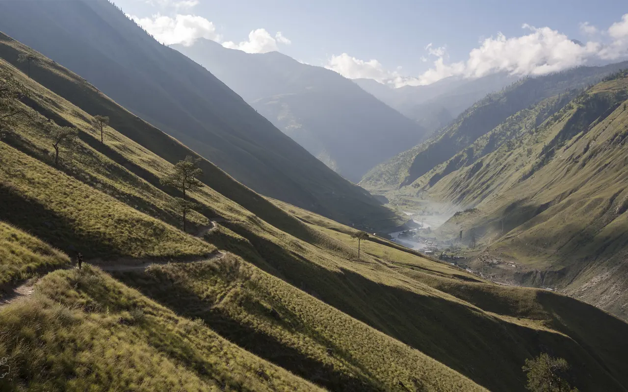
TeahouseThe Upper Dolpo Circuit Trek route still follows the Bheri River valley on the way to Dunai. The path goes through forests, small villages, and terraced agricultural areas where people cultivate crops.
The walk is largely pleasant and easy-going as the trek enters more fertile terrain at a lower elevation. Trekkers traverse suspension bridges and go by old villages where people live almost the same way they had lived generations before.
After several hours of trekking, you return to Dunai at 2,140 m / 7,021 ft, marking the end of the main Upper Dolpo Circuit Trek journey.
Activity & Duration
Trekking, 6 hrs hikingHighest Altitude
2,540m / 8,333ft (Tarakot)Meals
Breakfast, Lunch and DinnerAccommodation
TeahouseIt is the last day of the Dolpo region. The track leads the same way down the valley of the Thuli Bheri River back to Jhupal. The road then ascends slowly through the villages, terraces, and wooded hills.
On the pathway, you could encounter the locals of the village toiling in their farms or driving animals through the valley. This last walk is most pleasant due to the picture of green hills and running rivers in peace.
A few hours of walking bring you to Jhupal (2,475m / 8,120 ft). This is a small mountain airstrip, which forms the primary access point between the Dolpo region and Nepalgunj. Tonight, you will spend the last night in the mountains before you go back to the city.
Activity & Duration
Trekking, 6–7 hrs hikingHighest Altitude
2,475m / 8,120ft (Jhupal)Meals
Breakfast, Lunch and DinnerAccommodation
TeahouseIt is the end of the Upper Dolpo Circuit Trek today with an early morning flight from Jhupal to Nepalgunj. The mountain flight is a short aerial trip around rugged hills and deep valleys in the west of Nepal.
Once you have landed in Nepalgunj (150 m / 492 ft), you join another flight heading back to Kathmandu. On the way back, you have the chance to see rivers and green hills and scattered settlements once again.
The trekking journey is officially over at Kathmandu (1,400 m / 4,593 ft). The remaining part of the day may be spent by means of relaxation in your hotel, sightseeing the city, or you can celebrate the successful completion of the Upper Dolpo Circuit Trek.
Activity & Duration
Flight, 2 hrs flightHighest Altitude
2,475m / 8,120ft (Jhupal)Meals
Breakfast, Lunch and DinnerAccommodation
HotelTrip Information
Weather and Best Season
The most appropriate time of the year to have the Upper Dolpo Circuit Trek is in spring (April-June) and autumn (September-October). The seasons are well-balanced with reliable weather, clear skies, and comfortable temperatures for trekking.
During spring, the trekkers are able to see beautiful alpine flowers blooming on the trail and take pleasure in good weather. In autumn, there are good mountain and dry trails.
During winter, there is a lot of snow in the high places, whereas during summer, monsoon seasons can cause the low places on the trails to be wet and slippery.
Foods and Drink
The trekking staff serves trekkers with simple yet healthy food during the Upper Dolpo Circuit Trek. Himalayan Pathways offers a combination of Nepalese, Tibetan, and a few international products for breakfast, lunch, and dinner. Foods eaten in common are rice, lentil soup (dal), vegetables, noodles, pasta, potatoes, and soups. Breakfast can consist of porridge, eggs, bread, and tea.
In higher villages over 3,600 m / 11,811 ft, food choices are reduced, hence the meals are the simplest yet nutritious. It is important to drink as much safe water as possible when the trek is on. During trekking, a minimum of three to four liters of water should be consumed, particularly when you are at high altitudes of approximately 4,500 m / 14,764 ft.
Altitude Sickness
The Upper Dolpo Circuit Trek has the potential for altitude sickness since the walk takes you to high elevations. Certain sections of the trek exceed 5,000 m / 16,404 ft, where the oxygen level is reduced. The typical presented symptoms are headache, nausea, dizziness, and fatigue.
The itinerary of Himalayan Pathways is well-planned, including an acclimatization day in such places as Phoksundo Lake (3,611 m / 11,847 ft), to help the trekkers to adapt to the elevation.
Slow walking, consuming sufficient water, and proper resting are also major remedies for the prevention of altitude sickness. Guides keep a check on the trekkers and take safety measures. The secret of the successful completion of the trek is good acclimatization.
Preparation and Fitness
The Upper Dolpo Circuit Trek can be made safe and fun with the help of good preparation. The trek is characterized by many long trekking days, 5-7 hours a day on average, and elevations of more than 5,000 m / 16,404 ft.
Physical training by the trekkers should start a few weeks prior to the trek. Taking regular hiking, walking, cycling, or cardio activity will build stamina. Leg and core muscle strength training are also useful. Short hikes using a light pack should be practiced before the trek.
Mental training is also necessary since certain regions of the Dolpo area are isolated and primitive. By being fit and well-equipped, trekkers are able to make the adventure more comfortable.
Visa and Permits
Individuals who engage in the Upper Dolpo Circuit Trek require various permits as the area is restricted. The international visitors are expected to have an authentic Nepal tourist visa.
Moreover, trekkers need a Restricted Area Permit of Upper Dolpo and an entry permit of Shey Phoksundo National Park.
Himalayan Pathways deals with the permit system to facilitate the travel of the visitors. The trek goes through conservation zones and ascending mountainous places of over 4,000 m / 13,123 ft; as such, permits are significant in conservation and safety. Permits should be carried at all times when travelling.
Health and Safety
The Upper Dolpo Circuit Trek is very important in terms of health and safety. The trek is done in isolated mountain terrain with few medical centers. Himalayan Pathways offers seasoned guides to maintain good health. Drinking clean water, eating well, and getting good rest are necessary.
Cold climate at a higher altitude of 4,800 m / 15,748 ft. is also an aspect that needs protection by taking personal medicine, sunscreen, and warm clothes. Guides get prepared in case of an emergency and altitude problems. Most travelers safely go through the journey with proper planning and careful trekking.
Transportation
The Upper Dolpo Circuit Trek can typically be accessed by having a flight from Kathmandu to Nepalgunj. From Nepalgunj, a little mountain flight to Jhupal at 2,475 m / 8,120 ft is taken, which is the beginning of the trek. These flights provide a picturesque scenery of hills and the Himalayas. All the transport for the trekkers is organized by Himalayan Pathways, such as airport transportation and domestic flights.
Upon the completion of the trek, the travelers are flown back to Nepalgunj from Jhupal and further to Kathmandu. Due to the reliance of the flight on the weather situation within the mountains, there can be certain delays, particularly in places with elevated areas.
Travel Insurance
Anyone going to the Upper Dolpo Circuit Trek should highly consider travel insurance. High-altitude trekking, medical care, and helicopter evacuation against any emergency are to be covered by insurance in remote mountain areas that might be more than 5,000 m / 16,404 ft. deep.
Since the Dolpo region is remote, evacuation can be done by helicopters in serious cases of high-altitude sickness or injuries. Proper insurance is a source of peace and protection. Trekkers are advised to review their insurance policy to ensure that high-altitude trekking is covered by the insurance policy.
Alternative Routes
Although the Upper Dolpo Circuit Trek is the most frequented trail in the area, other trails can also be undertaken in Dolpo on treks. Some trekkers prefer the Lower Dolpo Trek, which tours the beautiful mountain surroundings around the Phoksundo Lake at 3,611 m / 11,847 ft with fewer high passes.
The other alternative is the Shey Phoksundo Trek, which emphasizes the national park area primarily.
The Himalayan Pathways is able to organize tailor-made trekking trails based on the time and experience of trekking. These options continue to provide beautiful Himalayan views, Tibetan culture, and isolated mountain walking experiences, though they offer a bit shorter or less challenging trekking.
Your Extra Expenses
Most of the key expenses of the trek, including guides, meals, accommodation, and permits, are typically covered within the trekking package during the Upper Dolpo Circuit Trek. Nonetheless, personal costs should also be planned by the trekkers. This can be snacks, cold beverages, hot showers at certain villages, or minor purchases in the local shops.
In isolated communities above 4,000 m / 13,123 ft, supplies are scarce and can even be costlier due to the fact that the good is carried by animals. Himalayan Pathways suggests that one carry a bit of additional cash in Nepalese rupees to spend on one’s own.
Guides and porters also usually receive tips at the end of the trek, which is not included in the package.
Language and Communication
Nepali is the official language of Nepal, even though there are numerous variations of local dialects in the Dolpo region. Trekking guides speak English, so international visitors can communicate easily during the Upper Dolpo Circuit Trek. Local people usually speak Tibetan dialects.
It is valued when an outsider learns some simple Nepali greetings like Namaste. It may not be easy to communicate with the villagers all the time, yet there are those smiles and basic gestures that can be used to establish good interaction with the people during the trek.
Internet and Charging Mobile Network.
During the Upper Dolpo Circuit Trek, there is limited network coverage on mobile phones since the area is remote. Some mobile signal can be obtained in the lower villages, such as Dunai. Network coverage, however, is extremely weak or non-existent in higher places above 4,000 m / 13,123 ft. The trail also has little access to the internet.
Himalayan Pathways recommends the communication of family and friends before the trek, as communication might be restricted. In certain villages, it might be possible to charge for the use of electronic devices at an extra fee. It is good to carry a power bank or a solar charger on the trek.
Don’ts on This Trip
Another important thing when doing the Upper Dolpo Circuit Trek is that one should pay respect to the local culture and nature. Trekkers are not supposed to litter and carry the garbage until it can be deposited. One should also avoid disturbing wildlife in the Shey Phoksundo National Park.
Travelers who are visiting a village and a monastery should dress decently and seek permission before taking pictures of people. Himalayan Pathways promotes sustainable trekking in order to serve the environment and local culture. One should not engage in loud behavior, the destruction of religious places, or neglect of the local practices.
Is the Trip beginner-friendly?
The Upper Dolpo Circuit Trek is regarded as a difficult trek, not an adventure on a beginner level. The trail has many trekking days and mountain passes over 5,000 m / 16,404 ft. There are remote locations that have few amenities. This trek is for individuals who have prior experience in trekking or are physically fit.
Nevertheless, beginners who train and keep fit can make it through the journey with proper guidance. It is significant to train, get acclimated gradually, and act according to the instructions of the guide. The distant sceneries and unique culture make the journey highly rewarding to resolute trekkers.
Trip Extension
Following the completion of the Upper Dolpo Circuit Trek, most of the visitors decide to continue with their journey to see more of Nepal. Among the trendy activities are sightseeing in Kathmandu, the cultural city of Bhaktapur, or going to Pokhara to enjoy the mountain view and relax. Other trekkers also combine the Dolpo trip with a trip to Lumbini, the birthplace of Buddha.
Himalayan Pathways will be able to organize tailor-made extensions of your trip based on interested activities and timeline. Such other experiences give the travelers an opportunity to appreciate the culture, history, and the landscapes of Nepal outside the high trekking routes above 4,000 m / 13,123 ft.
Photography & Drone Rules
The Dolpo Circuit Trek is a great trek that has brilliant photography chances, consisting of dramatic mountains, lakes of turquoise, and traditional villages. One of the most photographed locations in the area is Phoksundo Lake at 3,611 m 11,847 ft.
Trekkers are expected to observe local traditions and not take pictures without seeking permission from people or celebrating religious events.
The drone operations in Nepal are controlled and must be approved by the government. Himalayan Pathways may offer recommendations in case you want to carry drones. It is illegal to operate flying drones without permission.
Practical photography is a way of conserving the beautiful nature of the Dolpo region.
Cultural Festivals on the Trail.
During the Upper Dolpo Circuit Trek, you might get to encounter local cultural festivals, provided that you visit in time. Numerous villages have traditional Buddhist festivals in the monasteries. In some places, such as Shey Gompa (4,343 m / 14,249 ft), religious rites and gatherings are held.
These festivals involve traditional music, bright masks, and religious dances by the monks. Himalayan Pathways urges trekkers to be respectful of such events. The festivals belong to the local culture and will give a better insight into the spiritual practices that influence life in the Dolpo region.
Travel tips to Nepal First Time Visitors.
Visitors on the Upper Dolpo Circuit Trek should respect the local culture and natural environment, which may be new to them. Nepal is home to various landscapes, such as low valleys and high mountains with heights of over 5,000 m / 16,404 ft. Kathmandu requires a day or two before the actual trek to help one adapt and get equipment ready. Consumption of bottled or purified water is important to prevent for water borne diseases.
Local practices must be respected, and you must dress decently. Warm layers of clothes must be worn during high altitudes, like 4,800 m / 15,748 ft, and should also be carried by the travelers. Through proper planning, tourists can have a memorable trip in Nepal.
Frequently Asked Questions
What is the total distance of the Upper Dolpo Circuit Trek?
The entire Upper Dolpo Circuit Trek is about 200-230 km (124-143 miles), including the actual trail, along with the side trips.
How many high passes are crossed during the trek?
You cross two high passes that are Kang La Pass (5,360 m / 17,585 ft) and Jeng La Pass (5,090 m / 16,699 ft).
Is the Upper Dolpo area remote?
Upper Dolpo is a very remote trekking area in Nepal. The Dolpo region does not experience a lot of tourist traffic, unlike other popular destinations, like Everest or Annapurna.
What accommodations are found on the trek?
Basic teahouses in the villages and camping in the more remote parts, when no lodges are available, are normally part of the accommodation.
What number of trekking hours is supposed to be experienced in a day?
Trekkers normally walk between 5-7 hours a day and on high pass days, 7-8 hours, depending on the trail conditions and altitude.
Do I need a guide on the Upper Dolpo Circuit Trek?
Yes, an Upper Dolpo trek is in a restricted area, and one should have a licensed guide.
What is the kind of wildlife can be observed in Shey Phoksundo National Park?
Himalayan wildlife such as blue sheep, Himalayan musk deer, snow leopards, and different species of birds that have adapted to high altitude are found in the national park.
How is the Dolpo region unique with respect to culture?
Dolpo maintains the powerful Tibetan Buddhist traditions and ancient practices that have stayed same over the centuries. Most of the villages are traditional, with the activities practiced being yak herding and barley farming.
What is so significant about Shey Gompa?
Shey Gompa is a prehistoric monastery that is over 800 years old and a holy location. It is linked with the Crystal Mountain, which is a sacred mountain that pilgrims in the area walk around during religious celebrations.
What are the sceneries that the trek is expected to have?
The journey goes across various terrains such as forested valleys, alpine meadows, dry trans-Himalayan plateaus, deep river gorges, and high mountain passes, where one can see snow-filled peaks.
What cultural traditions are available to trekkers on the trail?
Prayer wheels, chortens, mani walls, monasteries, and colorful prayer flags are found all over the region. In Dolpo communities, there is a prevalence of religious practices and local rituals every day.
What was the trade route of Dolpo in history?
Historically, Dolpo was on the ancient salt trade route between Tibet and Nepal. Salt, wool, and grain were once carried over these high Himalayan valleys by traders.
What is the evolution of the scenery during the walk?
The topography evolves slowly from the green river valleys on the lower grounds to the dry plateaus of high altitude and bare mountains characteristic of the trans-Himalayan habitat.
How many acclimatization days are included on the itinerary?
The itinerary has 2 acclimatization days, mostly in Phoksundo Lake and Shey Gompa, to enable the trekkers to adapt safely to the rising altitude.
What are the cultural factors that shape the way of life in Upper Dolpo?
Tibetan culture and religion are very powerful in the region. A lot of traditions, clothing styles, architecture, and festivals are similar to those existing in Tibetan communities in the Himalayas.
What is so special about the Tarap Valley in the trek?
One of the biggest valleys in Dolpo is Tarap Valley, which has several traditional villages. It is marked by open scenery, agricultural settlements, and cultural values.
What is special about the Upper Dolpo Circuit Trek as compared to other treks in Nepal?
It is a trek that is both very remote and maintains Tibetan culture, dramatic, and not rushed by tourists as much as other well-known trekking paths in Nepal.
What is the average elevation level in the trek?
The trek starts at elevations of approximately 2,100 m / 6,890 ft and escalates to above 5,000 m / 16,404 ft, and the change of altitude is one of the key characteristics of the expedition.
Reviews on Upper Dolpo Circuit Trek
- Your safety, our priority
- Best price guarantee
- Experienced & dedicated team
- Easy booking, no hidden charge
- You can customize this trip