How difficult is the Nar Phu Valley trek?
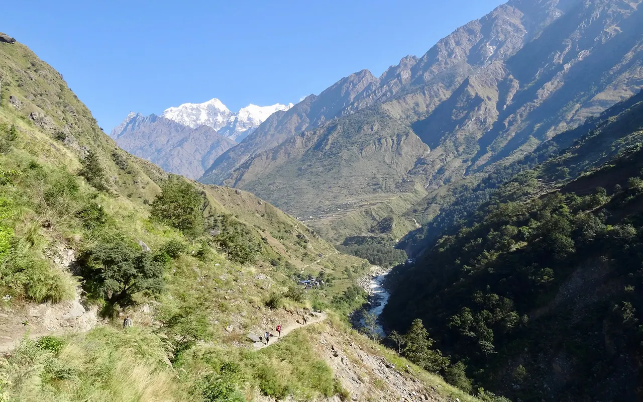
The Nar Phu Valley trek, apart from being very long, remote, and at high altitudes, is not challenging in a technical sense. Technical climbing is not necessary on the trail, although it is above 5,300 meters across the Kang La Pass and takes days of walking in a rough mountain setting. Five to eight hours of hiking are involved on steep, rocky, and uneven trails most days.
Some of the parts are physically challenging, especially the climbs to Nar village and the ascent to Kang La, where the thin air makes the task even more challenging. Physical stamina and psychological strength are relevant since the area is remote and the infrastructure is very rudimentary. Prior trekking knowledge is good, but not necessary in case you are well and physically fit.
The trekkers need to be comfortable with walking through rough surfaces and dealing with multiple days of hard work. The gradual increase, adequate acclimatisation, and frequent rest can be significantly changed.
The Nar Phu Valley trek is a challenging but not impossible undertaking that is highly rewarding to those willing to challenge themselves in a remote Himalayan location with reasonable preparations and the leadership of experienced guides.
Weather and Best Season for Nar Phu Valley trek
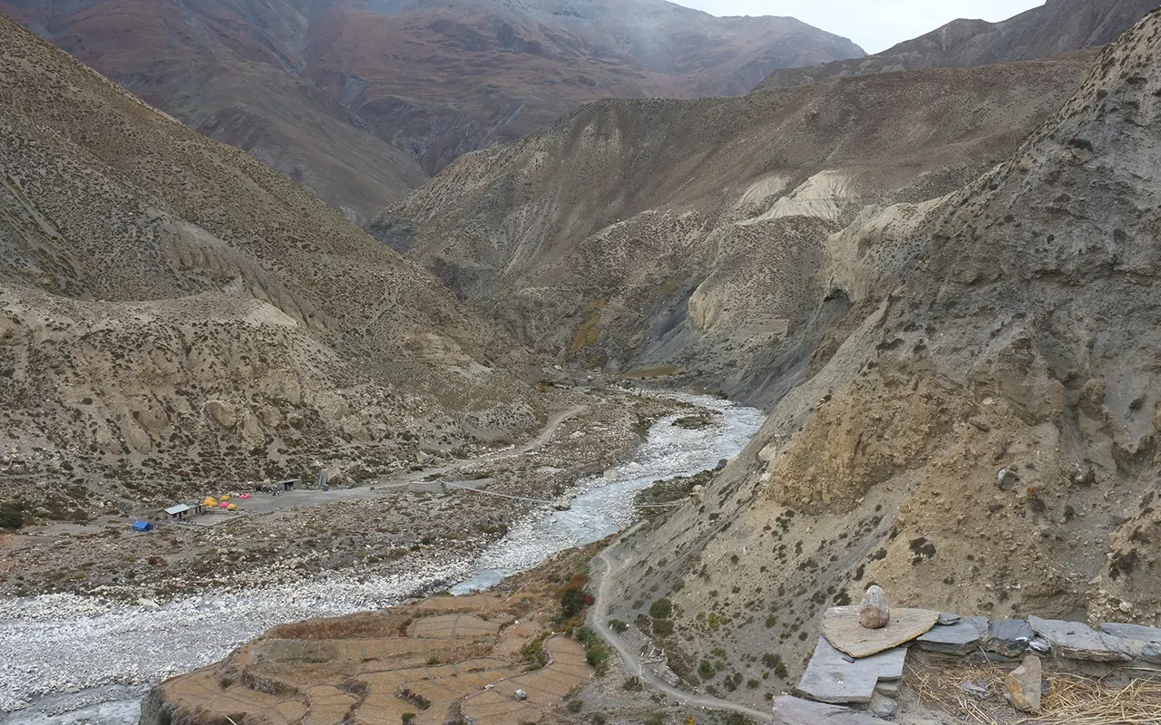
The Nar Phu Valley is in the rain shadow of the Annapurna range, so it receives significantly drier weather conditions than most other trekking areas in Nepal. For this reason, the best season to visit is during spring and autumn.
The period between March and May is usually steady as the weather is mild and the daylight is prolonged. The sceneries start opening out, and the sight is mostly clear and delightful, thus making the journey comfortable and picturesque.
Autumn, September-November, is also very popular. The monsoon normally clears the skies, the air is crisp, and the mountain scenery is at its finest. It is also the season of local festivals, which adds the colour of culture to the journey.
The summer or monsoon attracts fewer visitors. Although there is less rainfall in Nar Phu compared to the southern part of Nepal, the trails may be muddy at the lower altitudes. The greatest challenge is during winter when heavy snow and very cold temperatures usually block high passes.
To ensure the best conditions and be in the safest environment, spring and autumn are the best seasons to explore the Nar Phu Valley trek.
Food & Drink on Nar Phu Valley trek
The meals in the Nar Phu Valley trek are meant to be sustaining and rejuvenating, and not fancy. Teahouse menus are very basic as a result of the remoteness of the valley, yet they serve what the trekkers require in long walking days. The typical meal is dal bhat, a blend of rice, lentil soup, and vegetables, and is not only nutritious but also fulfilling.
It is also typically served with a lot of refills. Others usually involve noodle soups, fried rice, pasta, potatoes, momos, and light breakfast meals like porridge or omelettes. You can also find some local food, such as the roasted barley or the yak products, in Nar and Phu villages.
Food is as significant as water management. Plastic bottle usage is not encouraged, and bottled water is expensive. It is necessary to carry a refillable bottle. At the lodges, boiled water can be purchased at a minimal cost, and purification tablets or filters will enable you to use the local sources safely. The use of untreated water must be shunned at all times.
With the increase in altitude, the prices go up because of the transport difficulties, which are expected in remote areas. You should avoid alcohol, which influences acclimatisation and the hydration process. Drink warm herbal teas or ginger teas in the evenings. It is suggested to bring personal snacks because the choice is less as one reaches higher on the trail.
Altitude Sickness and Recommendations
The Nar Phu Valley trek is one of the trips when the issue of altitude sickness should not be overlooked because the path takes several days at an altitude of over 3,500 m and over a mountain pass. Acclimatisation is the best risk mitigation strategy.
To enable your body to adjust naturally, the itinerary is to enable a gradual increase in altitude, with a rest day in Phu. A slow pace, adequate intake of water, and abstinence from alcohol facilitate healthier adaptation to altitude.
Be aware of the way your body is. There are some early symptoms like headache, nausea, light dizziness, or disrupted sleep, which cannot be neglected. Provided there are symptoms, it is necessary to take a break and talk to your guide.
Nar Phu experiences fewer severe incidences than some other high-altitude treks because of its slow climb, although it is necessary to be careful.
Other trekkers opt to use Diamox, but visit a doctor before the Nar Phu Valley trek. Guides check the oxygen levels on a regular basis and have the basic medical equipment. In case severe symptoms emerge, it is only safe to descend. Through proper preparation, the majority of trekkers adapt and have fun on the trip without any harm.
Preparation and Fitness
Proper preparation will create an outline of an effective Nar Phu Valley trek. The training of stamina must begin a few weeks before the trek, and the emphasis must be on exercises that raise your heart rate and enhance stamina. Walking, hiking, cycling, or swimming are also good exercises that will prepare your body to spend long days on the trail. By practising in your trekking boots and an actual backpack, you will find it a lot easier to move to the mountains.
Balance and strength are also equally important. Powerful legs and a stable back assist in walking, going up and down, and moving on unstable grounds. Basic workouts and stretching will help a lot to relieve fatigue and injury potential. There is also a significant mental preparedness, and life on the trail is simple and requires patience and adaptability.
Take some time to walk for a few hours at a normal speed to know how comfortable you are. Learn how to form easy breathing. You will be refreshed and confident as your gear is prepared in advance, and when you go to Nepal, you will have time to rest. The Nar Phu Valley trek turns out to be fun instead of being a battle with constant training and the proper state of mind.
Visa and Permits
The tourist visa to Nepal is readily available to most travellers who may choose to get it at Kathmandu airport or at major land borders. One needs a minimum of six months’ passport validity and passport-sized photographs, and USD cash to pay the visa fee. The process of arrival is easy and normally fast at the airport counters.
The Nar Phu Valley requires further permits to do some trekking since it is a restricted area. A Restricted Area Permit is mandatory, and solo trekking is prohibited. An Annapurna Conservation Area Permit is also required, as well as a TIMS card that is utilised in the safety and record keeping of the trekker.
Himalayan Pathways handles all the permits and all the paperwork. All that trekkers have to do is book their passport information in advance. Throughout the trek, even the permits are inspected at some stages, thus carrying copies or the original permit is a good idea. When the paperwork has been done beforehand, you are able to solely concentrate on the journey.
Health & Safety
The Nar Phu Valley trek will be very pleasant and free of stress when health and safety are taken into consideration. Before the travel, a medical examination is highly recommendable especially to those with underlying ailments.
Bring all personal medicines and a small first-aid kit in case of small problems, like blisters, headaches, or stomach problems. Our guides are first aid trained and altitude aware, and they bring a common medical kit during the Nar Phu Valley trek.
You must keep up with your guide on the trail and take it step by step. Topography may consist of crossing rivers, narrow footways, and even slippery places, particularly following rain or snow cover. Being in a group will minimise the risk and assist each person in moving safely. The trekking poles make the trek more stable on rough surfaces and steep slopes.
One should not take unnecessary risks, not only in transportation, but also in exploring villages. Animals should not be approached, and stray dogs should be allowed space. Healthcare institutions are not near on the trail and therefore care and precaution are crucial.
The area is extremely safe; nevertheless, one should keep their valuables safe. The Nar Phu Valley trek is a challenge, but with planning, education, and collaboration, the trek can be completed safely and with ease by having our group assist you throughout the trek.
Transportation
It takes a whole day overland trip to reach Nar Phu Valley because the area does not have flights. The trip starts with a road adventure between Kathmandu and the starting point of the trail, Koto. Tourists will have the option of using the local transportation or a personal jeep, but the majority will use a 4×4 to have more comfort and versatility.
The trek typically requires approximately ten hours of driving, and it includes a combination of highways and rough mountain trails.
Having completed the trek, the route leaves from Ngawal or Pisang. At that place, a jeep ride will bring one back down to Besisahar, and this drive takes a couple of hours.
Then you proceed on to Kathmandu or Pokhara by road. Himalayan Pathways will also do all the transport logistics, and you can enjoy the landscapes as you go.
Travel Insurance
The Nar Phu Valley trek is a trek that requires travel insurance. It is an isolated and very remote trip; your policy must specifically mention trekking up to 6,000 meters and the use of emergency helicopter evacuation. Air rescue can be the quickest means of accessing medical treatment in a critical case like altitude illness or injury, and it could also be extremely expensive without insurance.
Medical treatment, hospitalisation, interruption of the trip, and loss or theft of personal belongings should also be covered. Review the policy specification before travelling, since there are some insurers that insist on the trekking activities being reported before travelling.
Bring a copy of your insurance papers and provide the contact details of your emergency policy number and contact information to our team. Although you might never have to apply it, good insurance is a guarantee of safety and peace of mind. All the trekkers on Himalayan Pathways should have legit insurance.
Alternative Routes
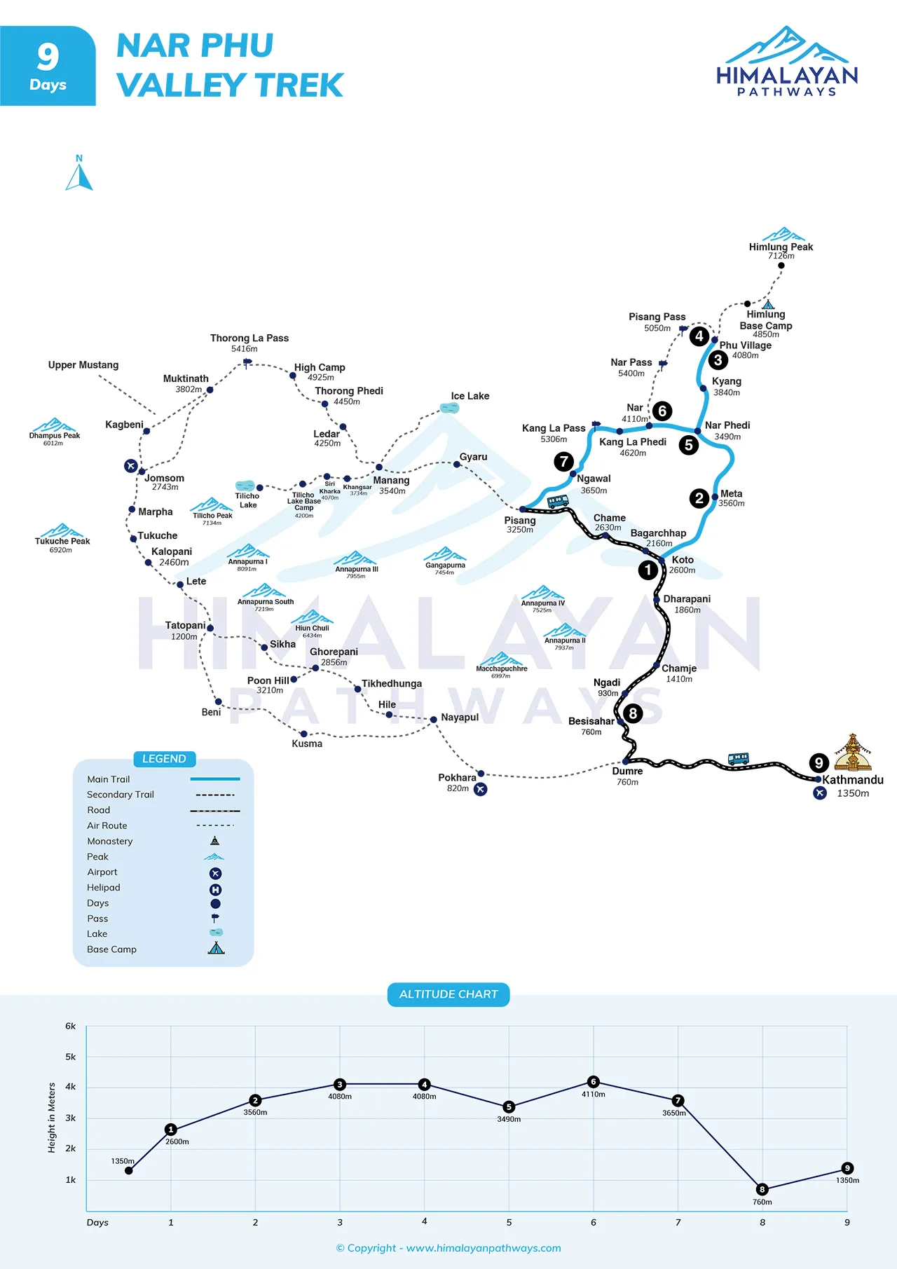
Nar Phu Valley trek is a typical trip that can be undertaken in 9 days, depending on the time one has or the interest, the route is capable of customisation.
Another most beneficial alternative is to connect Nar Phu and the Annapurna Circuit. Once Kang La Pass has been crossed, it may proceed to the Manang area and go further over Thorong La Pass and down to Muktinath and Jomsom. This makes the trip a more extended Himalayan adventure, which normally takes over two weeks, and an ending that is tidy in Pokhara.
Other trekkers will extend by including side trips as opposed to big extensions. A side trip between Manang and Tilicho Lake is a dramatic experience, and a high-altitude experience, but it will need more days of acclimatisation.
The less frequented ways of exit also exist, like difficult paths to Upper Mustang, that require additional permits and planning. Because Nar Phu is a side road of the main Annapurna trail, all the variations are concerned with the way of its combination with a wider itinerary. Himalayan Pathways is more flexible in designing the trek to your speed, interests, and general travelling plans.
Your extra expenses
The Nar Phu Valley trek package includes the main necessities, although it is always a good idea to budget some extra expenses to be able to travel comfortably. Other costs, like your Nepal visa or any trekking equipment you might need personally, are to be borne before you get into the mountains. In Kathmandu or Pokhara, hotel accommodation, meals, and transportation in the city have to be considered separately.
On the Nar Phu Valley trek, breakfast, lunch and dinner are included, but the personal snacks are optional. Teahouses take payment for the snacks, soft drinks, coffees or alcoholic beverages. Using water can be at a minimal fee in case you decide to have boiled water, and purification tablets or filters will help to cut down on the recurrent expenses.
Some of these lodge services are optional, but are often used, such as hot showers, Wi-Fi connectivity, and phone charges, which are usually additional, particularly in more remote villages with fewer resources. Cash is a necessity, since there are no ATMs in the mountains.
It is also traditional to tip your guide and the porter at the end of the Nar Phu Valley trek, which is highly valued, but the tip is negotiable. You also might need the additional funds in terms of souvenirs or a contingency for the weather or health. Budgeting will allow one to have a much easier, stress-free experience on the trekking trail.
Language & Communication
Nepal is a country that has Nepali as its national language, but Nar Phu Valley has a richer blend of cultures and speech. Nar and Phu are communities of Tibetan origin that speak a local dialect, which is affected by Tibetan and other Himalayan languages. The majority of residents also speak the Nepali language, and it assists in daily interaction within the area.
Language is not much of a barrier to trekkers. The route mostly has guides and teahouse owners who know basic English, and Himalayan Pathways guides are not only conversant with the English language but also the local lingo. This simplifies the communication process, particularly when one is staying in a village or paying a visit to a monastery.
Trail signs and checkpoints are also well indicated, thus making movement easy. Going the extra mile by using local expressions demonstrates respect and usually makes even the short interactions a memorable event.
Internet and Charging Facilities, Mobile Network
Nar Phu Valley is an isolated part of the Himalayas and is therefore not easy to stay in touch with. There are limited locations with mobile coverage that can be trusted. The primary service providers in Nepal are NTC and Ncell.
There might be a signal around Koto and occasionally in Meta, with Nar Village now having partial coverage via a local tower. The village of Phu and the winding gorges between villages are most often totally out of range.
There is even less access to the internet. Some Wi-Fi or satellite access might be provided in a few lodges in the lower village or in Nar at an additional fee, but the speed is slow and can only be used to send simple messages. Most trekkers do not have access to the internet on most of the route, and therefore, it is better to make prior arrangements with family and friends.
Teahouses have access to electricity, but the charging devices usually have a charge. Small hydro or solar-based power generation is used to produce power and may not be reliable. It can be strongly recommended to bring a power bank and an additional camera battery, particularly when the weather is colder. All in all, there is little to no connectivity and a peaceful escape from the digital world.
Don’ts on this trip
Trekking in the isolated Nar Phu Valley is difficult. The area is sensitive and conservative, and therefore, you need to be mindful of the way in which you get about. One cannot walk freely without an authorised guide, and it is rather dangerous and unlawful. By adhering to rules and obeying your guide, you will be safe, and you will not be violating any local rules that have been formulated in a way that preserves the area.
It is also essential for health awareness. Elevation is not something that all people aspire to, and neglecting the warning signs can become dangerous very fast. Rest days are not to be underestimated. You have to go at your own pace, and you should not hesitate to express yourself if you are not feeling well.
Environmental care is a must in such a location that has poor infrastructure. The idea of waste must always be exercised, and the idea of using less plastic does make a difference. This is where nature is still untouched since visitors walk cautiously. Livestock, wildlife, and farmlands should be seen from a distance because they are essential to the environment for a balance.
Everything is joined by cultural respect. Basic habits such as dressing decently, taking off shoes in the homes and asking permission before taking pictures demonstrate consciousness. It may be disrespectful to bargain or hurry in villages. Respectful compensation, appreciation, and goodwill are highly appreciated. Nar Phu is friendly and rich to those who travel intelligently.
Trip Extension
The Nar Phu Valley trek does not necessarily mean the final trek of Nepal. In case you have days to spare, there are numerous ways to keep on exploring, or just slow it down. As the trek is linked to the Annapurna region, several tourists visit Pokhara afterwards.
Individuals who desire to walk can include a short and easy walk from Pokhara, such as Poon hill where one can view the sunrise without having to undertake significant altitude challenges.
To have a total change of mind, southern Nepal has good wildlife experiences. Chitwan Natural Park is a good alternative, where jungle safari reveals jungles full of rhinos, deer, birds, and, at times, tigers.
Another good alternative is through cultural exploration. Kathmandu time can also allow one to visit some of the historic cities, temples, and stupas, which have a strong spiritual and artistic background in Nepal.
It can also be accompanied by scenic flights around the mountain or peaceful wellness retreats. Nepal has flexibility when it comes to having more adventure or having pure relaxation.
Himalayan Pathways will be able to assist in moulding the extension that will best suit you and your speed.
Photography & Drone Rules
The Nar Phu Valley has beautiful landscapes and a good cultural essence, thus it is an excellent destination to photograph. During the capturing of these moments, one must be sensitive to the local customs. Certain areas, like monasteries or active rituals, may prohibit photography, and this should never be broken.
The use of drones needs special authorisation from the aviation and government bodies, and local conservation offices. Drones must not be utilised at all in sensitive areas, as in the case of Nar Phu, a border region. Drones may also distract residents, other trekkers, and wildlife, hence remote and isolated locations are preferable.
In the case of ordinary photography, preparation is a huge factor. There is a scarcity of sources of power, and it is significant to have spares of batteries and memory cards. The use of prayer flags, stone chortens, spinning wheels, and village life paints the images that have a great impact on the representation of the spirit of the valley. Shoot what you are passionate about, but do not forget to look and feel what is beyond the camera.
Cultural Festivals on the Trail
Trekking in the Nar Phu Valley is not all about scenic views. It also leads to a very strong Himalayan culture. When your trip falls on the dates of local celebrations, this will mean that the trip is that much more special. Nar and Phu observe life per the Tibetan Buddhist calendar, and festivals are interwoven with community, religion, and nature.
The biggest festival is the Lhosar, the Tibetan New Year, which is celebrated in January or February. The villages are vibrant during this period in time. Individuals are dressed traditionally, praying houses are full, and families have dinner together and conduct ceremonial dances. It is a period of rebuilding, appreciating, and looking forward to the coming year.
Other minor festivals include Derchi and Yakchha, which are determined by the regional customs and the seasons. These incidents are usually associated with the activities of a monastic or the welfare of animals, particularly yaks. They are intimate and small events, hardly designed to attract tourists, so it is a real treat to come across one.
Since the path leads briefly into lower Annapurna village, one may also feel bigger Nepali celebrations such as Dashain or Tihar during autumn. Daily prayer ceremonies provide opportunities for relaxation and purpose, even on those days that are not during a festival. These are cultural experiences that you cannot forget after the expedition.
Tips for First-Time Nepal Travelers
It is a place of discovery to visit Nepal for the first time, particularly when you are travelling towards the mountains, such as the Nar Phu Valley. A bit of prior knowledge before you get there makes you much more relaxed and gives you a greater experience in the journey.
The Nepali culture is one of respect and simplicity. Simple dressing and conscious mannerism can accomplish much, especially in the villages, monasteries, and temples where customs are firmly held.
Food and water preferences should be given some attention. Avoid tap water and instead use purified or bottled water, which is safer. Freshly cooked meals are normally the easiest on the stomach, particularly when trekking. Local foods are simple, they give good energy, and are also very reliable for both the trekkers and guides.
Planning of the cash is relevant after leaving the cities. There are ATM locations everywhere in Kathmandu, but they do not exist in far-flung areas such as Nar Phu. Bring along an adequate amount of local currency in small bills, and shop very patiently and in good spirits.
Generally, Nepal is secure, but paying attention in crowded places and also depending on credible services is likely to save one the hassle.
Nature dictates travelling in Nepal. Scheduling is subject to change due to weather. It is easier with maintaining buffer days, be environmentally friendly, and flexible. Nepal is known to give much more than can be expected with patience and openness.
The Himalayan Pathways is constantly ready to pick you up on arrival and see you off when you are leaving, and thus your journey becomes something to remember and something significant.